Monday, April 30, 2012

City of Rocks National Reserve

Burley Library*, Idaho, Library


    While using all three hands to take a photo of the Howell Opera House in Oakley I managed to add slope to a level street. [:-)>]


    A side view of the Opera House in Oakley, which was founded in 1882. Saw another bldg with 1882 on it as well as a store which stated "Since 1923."


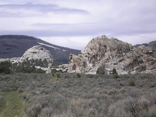
    A hint of things to come in the saddle through which the road traveled. [See the post below for routes & CG finders.]


    The road throughout the National Reserve is dirt and not suited for large RVs.


    [Click once to enlarge this, or any other photo.]


    While the snow was almost gone on the broad peak above my rig, more fell Monday night -- though not in large amounts. But that's what provides Idaho with more water than most of the other western states I've visited.


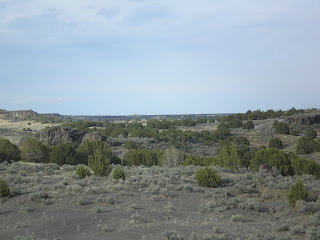
    Look closely between the trees in the middle of this photo.


    Can't recall if these rock formations were called the "bread loaves" -- or if that name was given to formations closer to the Oakley entrance.


    Many of those who visit the City of Rocks are rock climbers.


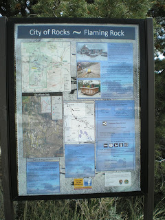
    Here are the two formations shown on the plaque in the photos above. There was someone on the formation to the right, but he didn't seem to be a very experience climber.


    Thought for a while that the weather forecast was wrong; but by the time I got to the Visitor Center in Almo, the sky had become overcast.


    The green valley in the center of the photo is where Almo, a cattle-raising area, is located.


    It's clear from some of the plaques that the Reserve is open during the winter time.


    Skipped Bath Rock since I wanted to stay in the warm cab of my pickup -- California Surfer Dude that I am!


    Some of the material on the bulletin boards is repetitive.


    Ditto!!


    The camera was level -- but the terrain sloped from right to left into Circle Creek or Valley.


    Double Ditto!!


    This is a look back toward the Emery Canyon Entrance (which I called the Oakley Entrance above).


    A view into the Circle Creek Valley (or Basin).


    A plaque next to Treasure Rock, where the overland travelers thought it was a "Pleasant Place" to camp.


    A look up at Treasure Rock -- though it looks more like Turtle Rock from where I took this photo.


    What's left of the William E. Tracey ranch house, which was started in 1896 but gutted by a fire in 1967.


    Another view of the Tracey ranch house.


    In the distance, the mountains of Northern Nevada in the Sawtooth National Forest.


    Panning left, the valley where Almo is located. The Visitor Center for the City of Rocks NR sits almost exactly on top of the California Trail.


    Panning further left....


    At the Visitor Center, a plaque which explains that the Conestogas used in movies were not used by travelers intent on crossing even the most minor mountain ranges.


    "Camped...." Stops at noon were for relief from the sun and heat; but the real camp was made at night, perhaps after obtaining water from the springs near Almo.


    Two replicas of the ligther-weight wagons used on both the California and Oregon Trails.


    The California Trail, which was very near this plaque, existed for a little over 20 years: from the discovery of gold on the American River at Colma in 1848 until the completion of the the transcontinental railroad by the Central & Union Pacific Railroads in 1869.


    Looking up from the plaque, here's a photo of some of the key peaks or mountain ranges noted in the illustrations on the plaque.


    A marker not far from the Raft River, which starts in the valley where Almo is located. It mentions many of the routes which branched off of the California Trail in this area.
    If you're interested, read The California Trail by George R. Stewart, author of Ordeal by Hunger, one of the better accounts of the Donner Party.
--
    * The Burley, ID, Library changes its WiFi passcode every day they are open. If, as I did, you arrive on a Sunday, you are SOL. Here's a link to their hours of operation.
Links:

--

T 1 May Actual Route: Burley bd - Burley Lib - Kimberley - Twin Falls - Perrine Memorial Bridge - Twin Falls Walmart

W 2 May Actual Route: Twin Falls Walmart - Twin Falls Lib - Shoshone Falls - Buhl - Miracle Hot Springs RV Park

Th 3 May Actual Route: Miracle Hot Springs RV Park - Hagerman Fossile Beds Natl Monument - Bliss - Gooding - Glenns Ferry - Three-Island Crossing State Park

F 4 May Route: Three-Island Crossing State Park - Mountain Home

--

Finding Campgrounds:

N.B. I receive nothing from Trailer Life, Woodalls, or FreeCampsites.net for including links to their free campground lookups.

Saturday, April 28, 2012

American Falls to Massacre Rocks State Park

Massacre Rocks State Park, Idaho

    An Idaho State Historical Marker (or billboard) at a Rest Area just east of Massacre Rocks State Park. [Incidentally, only 8 or 9 travelers were killed by the Shoshoni; a promoter in the 1920s decided to hype the event by calling it a massacre.]
    [Click once to see an enlarged, more-readable photo.]


    Looking back up the road from near Register Rock to Massacre Rocks SP one can see large 3-bladed wind turbines similar to those on Altamont Pass between Fremont in the Bay Area and Tracy in the Central Valley.


    Panning left one can see the placid Snake River -- though I did hear some radio forecast of possible flooding as warmer weather melts some of the snow.


    Panning furter left you can see a large island; sometimes those using the Oregon Trail attempted to cross the Snake at flat spots where there were multiple islands.


    Another look down the broad Snake River.
    The grove of trees on the left side of the road are where Register Rock was deposited during the Bonneville Flood. Those using the Oregon trail often scratched or chiseled their names in the rock. [Since there was a $5 parking fee, I turned around & headed back up the hill from which I took many of these photos before eating lunch. See links below.]


    Note two signs of the Bonneville Flood approximately 14,500 years ago: 1)Large boulders on the flat below as well as 2)a gap in the table mountain along the Snake River's northern edge.


    A view up the Snake River Valley toward American Falls, where some of the taller building or grain elevators are visible from c10 miles downstream.


    A closer look at the Big Sagebrush on this side of I-86 with large wind turbines among the Utah junipers on the other side.


    While Idaho seems to have plenty of water, here's evidence that there are pockets of dryness amongst the greenery: a young [probably 2-3 years old] prickly-pear cactus trying to gain a foothold.
--


Links:

--

Sa 28 Apr Actual Route: Willow Bay RV Park - American Falls Lib - Massacre Rocks State Park

Su 29 Apr Actual Route: Massacre Rocks State Park - Burley - Oakley City RV Park

M 30 Apr Actual Route: Oakley City RV Park - City of Rocks National Reserve - Almo - Elba - Malta - Declo - Burley bd

T 1 May Actual Route: Burley bd - Burley Lib - Kimberley - Twin Falls - Perrine Memorial Bridge - Twin Falls Walmart

W 2 May Actual Route: Twin Falls Walmart - Twin Falls Lib - Shoshone Falls - Buhl - Miracle Hot Springs RV Park

Th 3 May Route: Miracle Hot Springs RV Park - Hagerman - Bliss - Gooding

--

Finding Campgrounds:

N.B. I receive nothing from Trailer Life, Woodalls, or FreeCampsites.net for including links to their free campground lookups.

Tuesday, April 24, 2012

Craters of the Moon National Monument

Blackfoot Library, Idaho


    A first shot of the Pioneer Range on the way to Craters of the Moon National Monument


    The rounded hill looks suspiciously like a cinder cone/dome -- except that it's not very black.


    Another view of the Pioneer Range with spring snow from the previous day.


    One of the plaques at a Scenic Viewpoint near the entrance to the National Monument. Click once on the photo to see an enlarged photo. If you look closely, many of the passengers are wearing dust masks.


    A hint of things to come within the Monument.


    From the parking lot at the North Crater, which was volcanically active c2,000 years ago.


    A look up a cinder cone which is slowly being repopulated with vegetation -- particularly limber pines.


    Click once to see an enlarged photo of the plaque.


    Ditto.


    A shot of Grassy Cone, which is explained in the above plaque.


    What the Hawaiians call Pahoehoe, pronounced Pah-hoy-hoy; it is lava which oozes out and looks like rope.


    How lava flows.


    In the Devil's Orchard, a couple of basaltic formation.


    As you'll see later, lichen can grow on the outer surface of a rock, basaltic, granitic, etc.


    Part of my rig in the North Crater Parking lot.


    Some varied colors of rocks, not lichens.


    The majority of the trees are not Utah junipers but rather limber pines.


    If there are cinder cones, this area might be called a cinder field.


    Or a cinder field with grass.


    Some of the lava rock floated on top of the ciders. And there they stayed when both cooled.


    More evidence of the above.


    The hilltop volcanic formations look like a toadstool and a mouse.


    The National Park Service used the trail to this "cave," actually a "pipe" like those at Lava Beds Natl Monument in Northern California, to chide visitors for wearing a path to the cave instead of staying on the paved trail.


    Lichens functions much as canaries did in mines years ago.


    Bet monument visitors won't walk on these rocks!


    Just as the U.S. Forest Service learned not every fire should be surpress, the Park Service has apparently learned that dead are part of the ecosystem.


    The boys with the chains saws missed these dead trees -- or "got religion" early on.


    In the distance, the Big Southern Butte in the haze. [Click to enlarge.]


    A plaque outlining strategies for surviving in a climate with hot summers and cold winters.


    The top of all cinder cones is not necessarily the source of the frothy volcanic material spewed into the air.


    Inferno Cone and the well-worn path to the top.


    My rig with the snow-capped Pioneer Range in the background.


    A cinder cone (or field) yet to be populated with larger vegetation.


    One of the spatter cones (spewed heavier pieces of lava instead of lighter, frothier lava) with a small arch -- likely what's left of a collapsed pipe.


    The other spatter cone is called the Snow Cone.


    Here's a closer view. Ice! Think the name should be the Ice Cone rather than the Snow Cone.


    The other spatter cone with a paved path up to a pipe near its top.


    Three of the cones along The Great Rift, which is 52 miles long.


    A volcanic field near the spatter cones.


    The tube at the top of the spatter cone with the arch.
--


Links:

  • National Park Service web pages for Craters of the Moon National Monument
  • Wikipedia article on Craters of the Moon NM
  • More photos of Craters of the Moon on the NPS website
--

F 20 Apr Actual Route: Riverside RV & Trailer Park - Preston, ID - Pocatello - Bannock County Fairgrounds

Sa 21 Apr Actual Route: Bannock County Fairgrounds - Pocatello - Fort Hall - Blackfoot boon-dock

Su 22 Apr Actual Route: Blackfoot boon-dock - Idaho Falls - Targhee Inn & RV

M 23 Apr Actual Route: Targhee Inn & RV - Idaho Falls - Jcn US20 & US26 - Arco boon-dock

T 24 Apr Actual Route: Arco boon-dock - Craters of the Moon Natl Monument - Arco Lib - US26 boon-dock

W 25 Apr Actual Route: US26 boon-dock - Blackfoot Lib - Blackfoot boon-dock

Th 26 Apr Actual Route: Blackfoot boon-dock - Blackfoot Lib - Pocatello - Bannock County Fairgrounds

F 27 Apr Actual Route: Bannock County Fairgrounds - Pocatello Lib - American Falls - Willow Bay RV Park

Sa 28 Apr Actual Route: Willow Bay RV Park - American Falls Lib - Massacre Rocks State Park

Su 29 Apr Actual Route: Massacre Rocks State Park - Burley - Oakley City RV Park

M 30 Apr Route: Oakley City RV Park - City of Rocks National Reserve - Almo - Elba - Malta - Delco - Burley

--

Finding Campgrounds:

N.B. I receive nothing from Trailer Life, Woodalls, or FreeCampsites.net for including links to their free campground lookups.