Taos Public Library, New Mexico

Heading north on TX54 from Van Horn, here's a first view of the Guadalupe Mountains to the left of center. (It's a 74-mile drive from Van Horn to the Pine Springs Visitor Center.)

A large ranch gate to the left had this Texas Historical Marker near it about the Figure 2 Ranch and its founder, James M. Daugherty. [Click once to enlarge; press ESC to return here.]

The Guadalupe Mtns with Guadalupe Peak in in the center. Right? Only half-right, for the peak in the center is El Capitan.

A view of El Capitan (elev: 8085') from US Highways 62 & 180 as they curve around the Guadalupes before heading north toward Carlsbad Caverns.

The real Guadalupe Peak finally stands out below an interesting cloud formation; at 8749 ft. it's the highest point in Texas.

Panning to the left from the Pine Springs Visitor Center, the trail to the top starts at the campground about 3/8s of a mile above up the road, and heads for the gap you see; my guess is that it follows the ridge to the top.

Zooming in on both Guadalupe Peak and the cloud formation.

Driving US62/180 toward McKittrick Canyon I stopped and took a photo of the Capitan [fossil] Reef -- with El Capitan prominent on the left.

Since the round-trip walk up McKittrick Canyon to the [Wallace] Pratt Cabin is 4.8 miles, I made due with this photo from the McKittrick Canyon Visitor Center. Some of the trees listed in the canyon are maple, walnut, ash, oak, and chokeberry trees.

The rugged northern edge of McKittrick Canyon from the parking lot.

A first look at the Frijole Ranch, which was, for most of it history, known as the Smith Ranch.

The the ranch was founded by the Rader Brothers, but the Smith family moved here in 1906. During the 34 years they lived here, they made weekly wagon trips to Van Horn to sell their produce. Apparently the road was shorter then, but, nonetheless, it took them all night to get there with their fruit and vegetables covered with wet papers and rags. [Click once to enlarge; press ESC to return here.]

The key to the ranch's success: the spring, which is routed in several different directions from the corner of the spring-house.

The ranch's equivalent of a fridge: a stone building with water from the spring routed through it.

The back of the ranchhouse; note the small channel for the spring's water to run toward the garden and orchard.

Since I wanted to take photos of some cacti as well as a nearby cinder cone, I almost left without checking out the orchard. This tree is a winesap apple.

One of the many other fruit trees, which included apples, cherries, pears, persimmons, apricots, and even a crabapple.

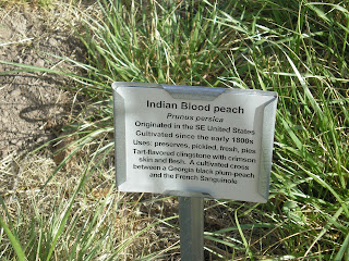
Memories of Home. My late father planted an Indian blood peach in our yard in Santa Cruz, CA. And, as one of the links below indicates, Thomas Jefferson had a considerable number planted on his estate in Monticello, VA. [Click once to enlarge; press ESC to return here.]

Two type of cacti, cholla & prickly-pear in front of a (Utah?) juniper.

A cinder-cone near the Frijole/Smith Ranch.
Links:
- Wikpedia article on Guadalupe Mtns Natl Park
- National Park Service web pages on Guadalupe Mtns Natl Park
- Frijole Ranch webpages within Guadulpe NP webpages
- A discussion of purple peaches such as the the Indian Blood Peach
T 23 Apr Actual Route: Santa Fe W/M - Southside Br Lib - Santa Fe Walmart
W 24 Apr Actual Route: Santa Fe W/M - Southside Br Lib - Santa Cruz - Espanola Walmart
Th 25 Apr Actual Route: Espanola Walmart - Velarde - Taos Library - Taos Walmart
F 26 Apr Actual Route: Taos Walmart - Taos Library - Eagle Nest - near Cimarron bd
Sa 27 Apr Actual Route: Cimarron bd - Cimarron - Raton Lib - Capulin - NM325 bd
Su 28 Apr Route: Capulin NM325 bd - Capulin Volcano Natl Monument - Clayton - Clayton Lake SP
M 29 Apr Actual Route: Clayton Lake SP - Kenton, OK - NM706 bd
T 30 Apr Actual Route: NM706 bd - Clayton Lib - Capulin Volcano NM - Folsom - Branson, CO - Trinidad Walmart
W 1 May Actual Route: Trinidad W/M - Thatcher - La Junta Lib - La Junta Walmart
Th 2 May Route: La Junta Walmart - La Junta Lib - La Junta Walmart
Finding Campgrounds:
- RV Campgrounds from TrailerLifeDirectory.com
- Family Camping Directories from Woodalls.com
- Free campsites website
- Info on finding BLM Campgrounds
No comments:
Post a Comment