Eagle Library, Colorado

Approximately 2,000 ft. above the junction of the Gunnison and Colorado Rivers lies a national monument which is similar to several nation parks or monuments in Utah -- especially Zion National Park. The water you see is the Colorado below its confluence with the Gunnison. [Photos taken on 13 & 14 Aug.]

Panning right we see more of "The Grand Valley," as the area around Grand Junction is known.

Though Grand Junction is a city of c50,000 people, there are still several vacant areas into which it could expand.

Panning right again from the "Redlands View" from just under 5,000 ft.

[Click once to enlarge; press ESC to return here.]The Redlands Fault had shaped the land here with many strong earthquakes.

Another plaque explaining the importance of the Redlands Fault.

Another look at the red in the Redlands Fault.

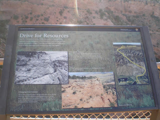
A plaque with a photo of the rather narrow trail to the top of the mesa where there was water and grass. Wonder how many head fell off of the trail and became a meal for coyotes, vultures, etc.?

While I thought I saw the former cattle "driveway" before I took this photo, I don't see it now.

Though I didn't see them there are apparently houses at Glade Park.

The many estuaries and ponds along the Colorado River to the west of Grand Junction.

A shot of Wedding Canyon from Book Cliffs View.

Zooming in on the "Pipe Organ."

Like such other national parks and monuments on the Colorado Plateau as Zion, Capitol Reef, Bryce, and the Grand Canyon, Erosion, with a capital E, is the key to these formations. Over time, wind, rain, snow, and ice wear away the sharp edges.

Often a layer of harder rock is left as a capstone atop a pedestal of softer rock.

Zooming in on Independence Monument, which was first climbed by John Otto, who first came to this area in 1907 and felt it should be a national park.It became a National Monument in 1911.

[Click once to enlarge; press ESC to return here.] Afraid of heights? Not these climbers, who repeat John Otto's raising of Old Glory each Independence Day.

As seen from Grand View, believe the formation in the center is called "Kissing Couple."

As this plaque indicates the building of 23-mile Rim Rock drive from the West (Fruita) Entrance/Exit to the West (Grand Jcn) Entrance/Exit did cost some loss of life. Nine workers were killed in 1933 (no indication if they were CCC workers) and two more men also perished.

As this plaque mentions early monument visitors said one formation looked like coke ovens, which were used particularly near mines to convert coal to a nearly-gasless fuel, coke.

The Coke Ovens as seen from their so-named Overlook.

Carry water if you're hiking through this area -- even if you're going downhill!

Not sure if this is Black Ridge, but the city of Grand Junction would be tough to reach via phone without out these towers.

I warned a couple arriving just as I left to beware of the trick question on swimming pools. The woman said, "How refreshing," as it was becoming increasingly hotter. This plaque & dry potholes is what I found after a 75-yard walk.

From the top of Red Rock Canyon looking out on the grand Valley.
- National Park Service website for Colorado National Monument
- Wikipedia article on Colorado Natl Monument
- Rob Kurtzman Photos of Colorado Natl Monument
Return to Top of Page
Th 15 Aug Actual Route: Montrose Walmart - Black Canyon of the Gunnison Natl Pk
F 16 Aug Actual Route: Black Canyon of the Gunnison Natl Pk - Curecanti Natl Rec Area CG
Sa 17 Aug Actual Route: Curecanti NRA CG - Gunnison Lib - Crested Butte bd
Su 18 Aug Actual Route: Crested Butte bd - Carbondale - Glenwood Springs Walmart
M 19 Aug Actual Route: Glenwood Springs W/M - Glenwood Sprs Lib - Carbondale Lib - Glenwood Springs W/M
T 20 Aug Actual Route: Glenwood Springs W/M - Glenwood Sprs McDs - Gypsum Lib - Eagle Lib - US6 bd
W 21 Aug Actual Route: US6 bd - Eagle Lib - Brush Crk Rd bd
Th 22 Aug Actual Route: Brush Crk Rd bd - Eagle Lib - Avon Starbucks - Avon Walmart
F 23 Aug Actual Route: Avon Walmart - Leadville USFS District Office - Lib - Twin Lakes CG
Sa 24 Aug Actual Route: Twin Lakes CG - Buena Vista P.O. - Lib - Cottonwood Pass Rd bd
Su 25 Aug Route: Cottonwood Pass Rd bd - Buena Vista Lib - Valley MHP & RV CG
Finding Campgrounds:
- RV Campgrounds from TrailerLifeDirectory.com
- Family Camping Directories from Woodalls.com
- Free campsites website
- Info on finding BLM Campgrounds


No comments:
Post a Comment