Friday, January 25, 2013

Coolidge to Catalina State Park, AZ

Ysleta Branch Library, El Paso, TX


    A Tom Mix Memorial along AZ79 south of Florence. It reads "Jan. 6, 1880 - Oct. 12, 1940[;]In Memory of TOM MIX[,] whose spirit left his body on this spot and whose characterization and portrayals in life served to better fix memories of the Old West in the minds of living men[.]"


    Turning to the left, a shot south to Mt. Lemmon in the distance to the left of my rig.


    Zooming in....


    Farther down AZ79 a photo taken from the east side of the road.


    With increasing cloud cover decreasing the available light, another look at Mt. Lemmon.


    A many-branched saguaro cactus silhouetted against the sky to the west.


    Another view to the west where there is more light thanks to less cloud-cover.


    The next morning a look at the Santa Catalina Mtns -- perhaps at Mt. Lemmon. A second examination seems to hint at snow-speckled mountains behind the tree towering over the RV in the right foreground.
--


Links:

--

Su 3 Feb Actual Route: Van Horn - Jcn I-10 & I-20 - Toyah - Pecos Flying J Truck Stop

M 4 Feb Actual Route: Pecos Flying J Truck Stop - Pecos Lib - Tra-Park Escapees CG

T 5 Feb Actual Route: Tra-Park Escapees CG - Pecos Lib - Tra-Park CG

W 6 Feb Actual Route: Tra-Park Escapees CG - Pecos Lib - Fort Stockton Walmart

Th 7 Feb Actual Route: Ft Stockton McDonalds - Ft Stockton Lib - Ft Stockton Walmart

F 8 Feb Actual Route: Fort Stockton W/M - Ft Stockton Lib - Alpine - BC Ranch RV Pk

Sa 9 Feb Actual Route: BC Ranch RV Pk - Alpine - W Entrance Big Bend NP - Cottonwood CG

Su 10 Feb Actual Route: Cottonwood CG - Mule Ears Viewpoint - Chisos Basin CG

M 11 Feb Actual Route: Chisos Basin CG - Panther Jcn P.O. - Chisos Basin CG

T 12 Feb Route: Chisos Basin CG - Panther Jcn P.O. - Peppermint Gap Entrance - Marathon
--

Finding Campgrounds:

N.B. I receive nothing from Trailer Life, Woodalls, or FreeCampsites.net for including links to their free campground lookups.

Tuesday, January 15, 2013

Casa Grande Runins National Monument

Yselta Branch Library, El Paso, TX


    From the Coolidge, AZ, Safeway Parking lot: one of the better sunsets I've been able to catch.


    Walking to the south I was able to eliminate the parking lot lights -- but not the high TV antennas or power poles.


    Hedgehog Cactus at Casa Grand Ruins National Monument.


    Robust Hedgehog Cactus.


    Firebarrel Cactus.


    Named by the first Spaniards (priests) to arrive on the site "Casa Grande." It was originally four stories high, 60 feet long, and weighed 3,000 tons. It was the center of Hohokam settlements which used canals to divert water from the Salt and Gila Rivers to grow corns, beans, squash, tobacco, cotton, and agave.


    The Hohokam had no slaves as did the Egyptians pharaols; they carried the caliche [cul-LEE-chee], a mixture of sand, clay, and limestone, into the rising "Great House" on their backs, which was completed about 1350 A.D. However, what is regarded as the Classic Period was over by the early 1400s -- perhaps because of drought.
    
    Each wall of Casa Grande faces a principal direction of the compass. The west wall had a round hole in it which, on 21 Jun, the Summer Soltice, the sun shone through it onto an opposing wall. And the moon shone through a square hole on the west wall approximately every 18.5 years when the moon reached what is call a "lunar standstill"; that is, within two weeks it moved from high in the night sky to low in the morning sky near the horizon. You might call Casa Grande an "American Stonehenge."


    Because early visitors to the ruins either defaced or carried off parts of what they found, many portions of the ruins are "off-limits" now.


    Believe the docent said the original roof over the ruins was erected in 1935 at a cost which is now a fraction of the cost to paint the roof and its supports.


    A plaque which explains the prevalence of Platform Mounds during the Classic Period (c1300-1450).


    The plaque explains that ballcourts were very uniform throughout the Hohokam settlements and were similar to those in Central Mexico. The one at Casa Grande was large enough for between 350 and 600 spectators. [Don't know if there were "bookies" who handled wagers on the outcomes of the ballgames, but it wouldn't surprise me.]


    The Hohokam were a peaceful group which traded pottery and jewelry for shells from the Gulf of California as well as for Macaws, mirrors, and copper bells from tropical Mexico.


    A map of other archeological sites in Arizona as well as state and national parks and monuments.
--
Links:

--

M 21 Jan Actual Route: Las Cruces Walmart - Big Lots - Las Cruces Walmart

T 22 Jan Actual Route: Las Cruces Walmart - Dollar Tree - Library - Las Cruces Walmart

W 23 Jan Actual Route: Las Cruces Walmart - Library - Anthony - El Paso Alameda Ave Walmart

Th 24 Jan Actual Route: El Paso Alameda Ave Walmart - Socorro - Ysleta Br Lib - El Paso Alameda Ave Walmart

F 25 Jan Actual Route: El Paso Alameda Ave Walmart - Ysleta Br Lib - Horizon City Town Hall - Socorro - Ysleta Br Lib - El Paso Alameda Ave Walmart

Sa 26 Jan Actual Route: El Paso Alameda Ave Walmart - Ysleta Br Lib - El Paso Alameda Ave Walmart

Su 27 Jan Actual Route: El Paso Alameda Ave Walmart - Ysleta Br Lib - El Paso Alameda Ave Walmart

M 28 Jan Actual Route: El Paso Alameda Ave Walmart - Dollar Tree - Ysleta Br Lib - El Paso Alameda Ave Walmart

T 29 Jan Actual Route: El Paso Alameda Ave Walmart - Ysleta Br Lib - El Paso Alameda Ave Walmart

W 30 Jan Route: El Paso Alameda Ave Walmart - Ysleta Br Lib - Socorro P.O.
--

Finding Campgrounds:

N.B. I receive nothing from Trailer Life, Woodalls, or FreeCampsites.net for including links to their free campground lookups.

Sunday, January 6, 2013

Joshua Tree National Park

Sagebrush RV Park*, Willcox, AZ
    When is a tree not a tree? When it's a yucca.
    Legend or rumor has it that the Mormons named the "trees" after the Bible's Joshua. The tallest tree in the park is just over 40'; hwr, it has no branches -- which means it never had blossoms. A winter freeze is believed to be necessary for the ends of branches to have blossoms in the spring; and then a yucca moth has to lay its eggs in the ovaries of one or more blossoms.
    This Joshua Tree, seen in the late afternoon sun not too far from the Jumbo Rocks Campground, has had a more difficult existence than those in the photo above along the Keys View Rd.
    Inicdentally, a Joshua tree is a member of the Agave family with a scientific name of Yucca brevifolia.


    On the boundary. The western half of Joshua Tree NP is generally above 3000 ft. and part of the Mojave Desert; the eastern half is less than 3000 ft. and is Colorado Desert habitat.


    Some monzogranitic rocks at the Ryan Ranch Trailhead Parking Area -- and a hint of things to come at the Jumbo Rocks Campground.


    Another closer look to the left of the rocks in the above photo just before sunset.


    A plaque explaining the Ryan Ranch, a homestead established before the turn of the 20th century. [Click once to enlarge; press ESC to return here.]


    A shot of the namesake of the Jumbo Rocks Campground from just in front of Site #85 (of, if mem serves, 125 sites).


    A "forest" of Joshua Trees along the Keys Veiw Road.


    A look to the northwest from Keys View looking at snow on San Gorgonia Peak (11,500') north of the Coachella Valley.
    Keys View is a must-see. But if your're driving a large RV or pulling an equally large 5th-Wheeler, you'll have to park and use your toad or tow vehicke, ride a bike six miles uphill, or, if you're really in shape, use "Shank's Mare."


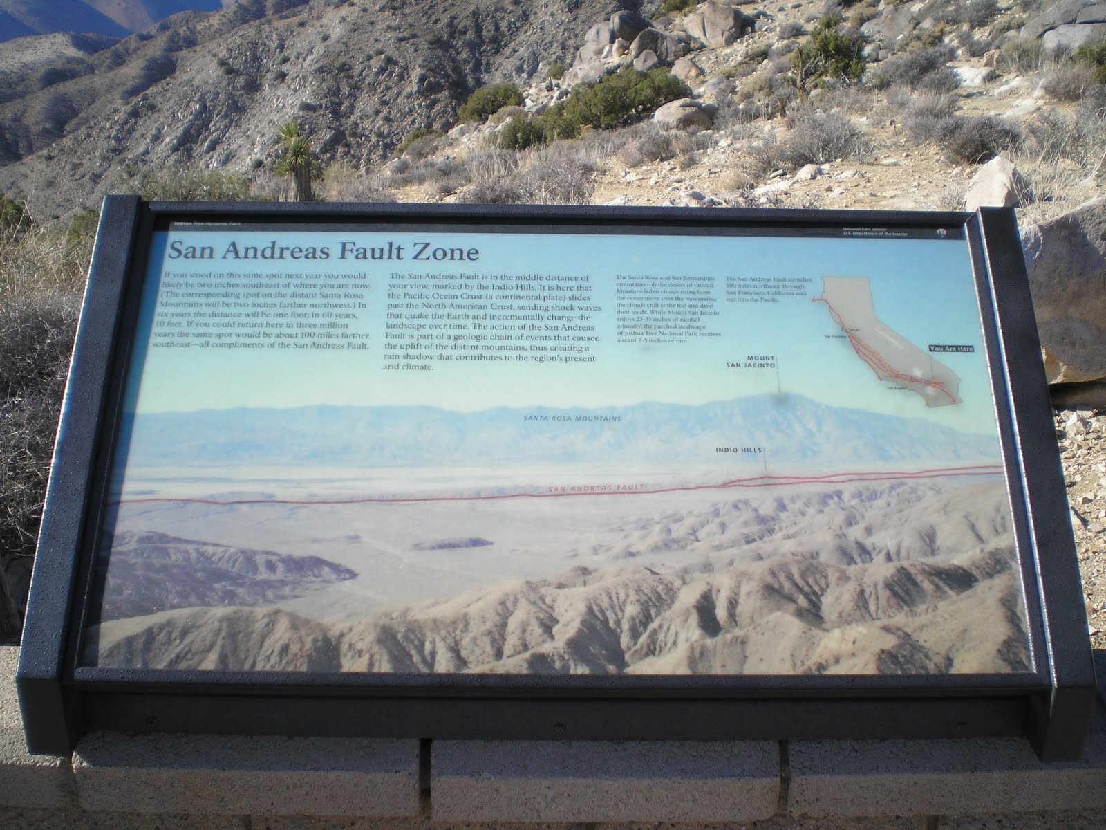
    Panning left, the snow-capped peak is Mt Jacinto (10,831') and the small ridge running down the Coachella Valley is the San Andreas Fault, which extends 500 miles to the north thru San Francisco, Tomales Bay, and then out to sea.


    Panning left again, one can see reflections off of the buildings along the west side of the Coachella Valley from Palm Springs to Indio.


    Panning yet farther left, one can see the upper end of the Salton Sea, which, along with Death Valley, contain two of the lowest spots in California; both are more than 200 ft below sea level. [Click once to enlarge; press ESC to return here.]


    Another look to the south at the Salton Sea.


    A plaque which identifies points of interest in the Coachella Valley. [Click once to enlarge; press ESC to return here.]


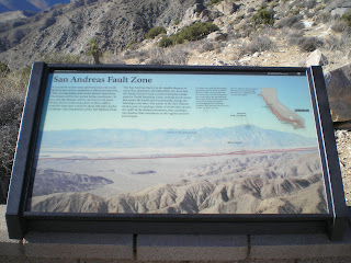
    Another plaque -- this one on the San Andreas Fault.


    An explanation of the Joshua Tree as a key habit for many birds, mammals, insects, and reptitles.


    Panning to the upper left from the plaque, a "forest" of somehwhat "weather-beaten" Joshua Trees.


    The Joshua Tree seeds which sprout are often those which were shelter by undergrowth which obscures them from feeding birds and animals.


    Some rock formations with no Joshua Trees present.


    Panning right....


    Panning farther right....


    A final cluster of granitic rocks.


    Aptly-named Skull Rock.


    Heading south toward Cottonwood Springs I came across the Cholla Cactus Garden. The Teddy-Bear Cholla are also called the Jumping Cholla "for their tendancy to attach themselves to the unwary."


    A closeup of the "cuddly" teddy-bear cactus. I tried kicking a piece of cactus which was on the ground along my way back to my rig. And it "jumped" to the toe of my shoe. Several violent kicks failed to dislodge it. Finally, I knocked it off by kicking the corner of a rock.


    A plaque explaining the ocotillo, a plant which does not depend on seasons but rather rain to sprout; in fact, it may sprout leaves and red blossoms as many as five times a year.


    A closeup of an Ocotillo in the Ocotillo Patch along the Pinto Basin road to the southern entrance (Cottonwood Visitor Center) to Joshua Tree National Park.


--
* Sagebrush MH & RV Park: great shower & reasonable prices.
--
Links:

--

Su 20 Jan Actual Route: Wagon Wheel RV Pk - Las Cruces Walmart

M 21 Jan Actual Route: Las Cruces Walmart - Big Lots - Las Cruces Walmart

T 22 Jan Actual Route: Las Cruces Walmart - Dollar Tree - Library - Las Cruces Walmart

W 23 Jan Actual Route: Las Cruces Walmart - Library - Anthony - El Paso Alameda Ave Walmart

Th 24 Jan Actual Route: El Paso Alameda Ave Walmart - Socorro - Ysleta Br Lib - El Paso Alameda Ave Walmart

F 25 Jan Actual Route: El Paso Alameda Ave Walmart - Ysleta Br Lib - Horizon City Town Hall - Socorro - Ysleta Br Lib - El Paso Alameda Ave Walmart

Sa 26 Jan Actual Route: El Paso Alameda Ave Walmart - Ysleta Br Lib - El Paso Alameda Ave Walmart

Su 27 Jan Actual Route: El Paso Alameda Ave Walmart - Ysleta Br Lib - El Paso Alameda Ave Walmart

M 28 Jan Actual Route: El Paso Alameda Ave Walmart - Dollar Tree - Ysleta Br Lib - El Paso Alameda Ave Walmart

T 29 Jan Route: El Paso Alameda Ave Walmart - Ysleta Br Lib - El Paso Alameda Ave Walmart
--

Finding Campgrounds:

N.B. I receive nothing from Trailer Life, Woodalls, or FreeCampsites.net for including links to their free campground lookups.