Sunday, March 30, 2014

Some State High Points

Some State High Points

Moab Library, UT Updated on 25 May 2014

    Many of you may be wondering why I haven't been posting any new photos. The reason is that my new laptop/notebook runs Windows 8.1, and my camera manufacturer, Olympus, has not updated their Master software to work with Microsoft's latest Operating System. [A cynic might conclude that Olympus wants those of us using their older cameras to shell out for newer cameras. Per the advice of a UCSC computer science grad I ordered a USB card reader which may allow me to move photos from my camera to my laptop -- and thence to this blog.]

    Another software firm, Google, whose Picasa program allowed me to upload photos from my Olympus camera to my laptop, also has not updated that program to work with Win8.

    One of my goals during my travels has been to take photos of the highest peaks in each state I visit; what follows are the High Points in most of the western states as well as Texas and the Rocky Mtn states north to the Canadian border. (I debated whether to list the High Points in alphabetical order or some sort of geographic sequence; the latter won out!)


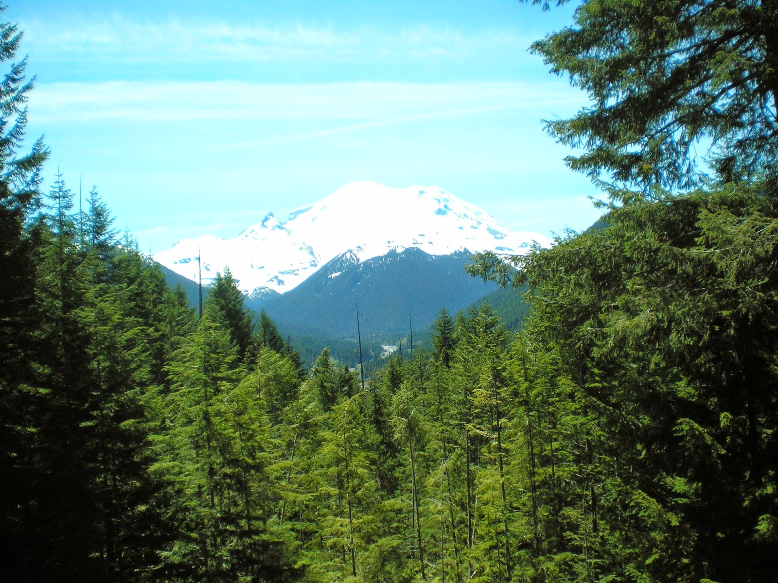
    A view of Washington's Mt. Rainier (14,414') taken on 12 Jun 2012.
    Natl Park Service website.


    The highest peak in Oregon is Mt. Hood at 11,249'; I have no photo of it yet; see the 1st link below.


    California's Mt Whitney (14,494') as seen from Inyo County's Portagee Joe Campground. For more info see the 2d entry in the Links below; it has an excellent photo on a National Park Service page called "Climbing Mt. Whtiney."


    Nevada's Boundary Peak (13,147') as seen from US Hwy 6 not too far from Montgomery Pass.


    More info.


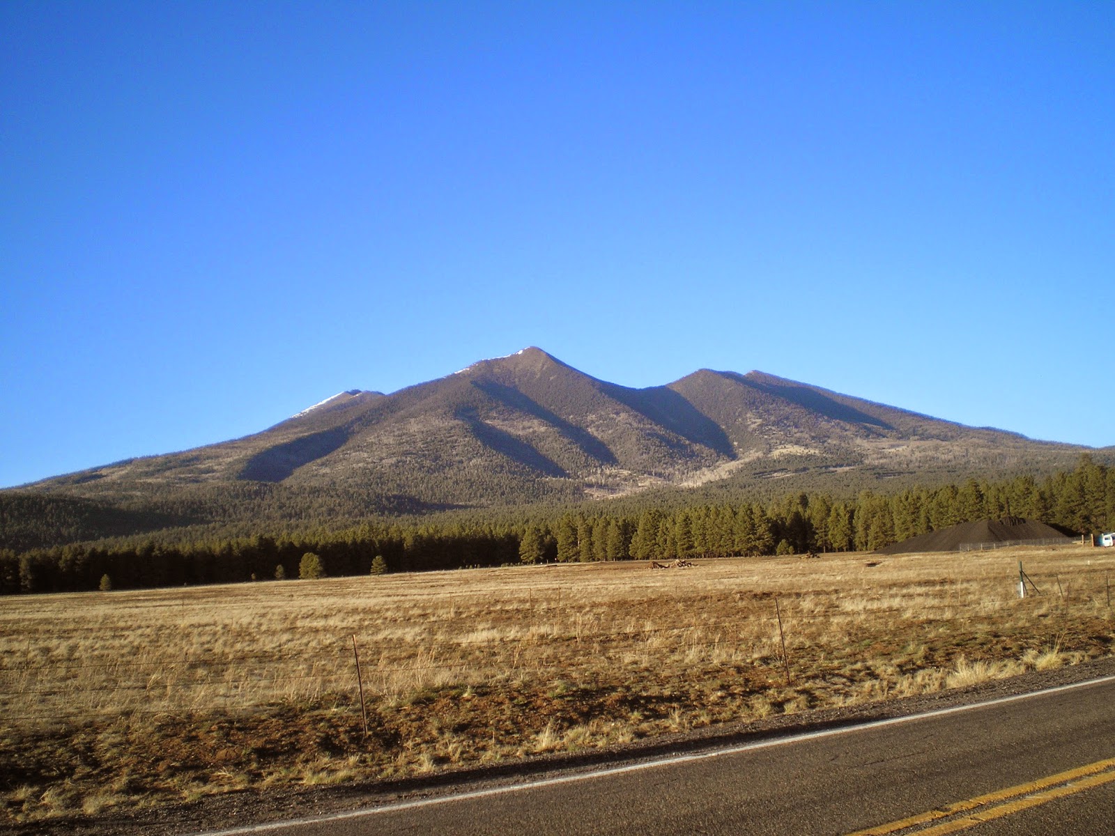
    Arizona's Humphrey's Peak (12,637') in the San Francisco Mtns just north of Flagstaff.
    See the 3d link below for more info.


    New Mexico's Wheeler Peak (13,159') to the north-east of Taos.

    More info.


    I drove around the Ashley Natl Forest hoping for a clear view of Utah's Kings Peak (13,534'), but there was never a clear shot until I was back on the nearest highway. See the 4th link below for a good photo.


    See 5th link below for a photo of Idaho's Borah Peak (12,662 or 12,668')


    See the 6th link below for a photo of Colorado's Mt Elbert (14,440')


    And Wyoming's Gannett Peak (13,809') is the 7th link below.


    Montana's Granite Peak (12,807') as seen from the Beartooth Highway.

    More info.


    Guadalupe Mtn (8,751'), TX, in Guadalupe Mtns Natl Park.


More info


    While reading my 2008 World Almanac I noted Mt Harney, the highest point in South Dakota and realized I had a photo of it taken after I visited Mt. Rushmore. See Link #8 below for more info.


[Return to the top of the page]
Links:
  1. Wikipedia article on Mt. Hood, OR
  2. Climbing Mt. Whitney
  3. Wikipedia article on Arizona's Humphrey's Peak
  4. Wikipedia article Utah's Kings Peak
  5. Wikipedia article on Idaho's Borah Peak
  6. Wikipedia article on Colorado's Mt Elbert
  7. Wikipedia article on Wyoming's Gannett Peak
  8. Wikipedia article on South Dakota's Harney Peak
  9. Wikipedia list of states by elevation

Routes:

Th 10 Apr Actual Route: Riverton W/M - Riverton P.O. - Payson - Nephi Lib - Ephraim W/M

F 11 Apr Actual Route: Ephraim W/M - McDs - Salina - Richfield Dollar Tree - Circleville - Panguitch Lib - UT143 bd

Sa 12 Apr Actual Route: UT143 bd - Panguitch Lib - Cedar Breaks Natl Mon - Kanab, UT - Vermilion Cliffs NM, AZ

Su 13 Apr Actual Route: Vermilion Cliffs NM - Marble Cyn - Grand Canyon NP - Flagstaff, AZ - Winslow bd

M 14 Apr Actual Route: Winslow bd - Holbrook Lib - Sanders, AZ - Gallup, NM, Walmart

T 15 Apr Actual Route: Gallup Walmart - Albuquerque - San Mateo Blvd & Zuni Rd W/M

W 16 Apr Actual Route: San Mateo & Zuni W/M - Erna Fergusson Br Lib - VA Hosp - San Mateo/Zuni W/M

Th 17 Apr Actual Route: San Mateo/Zuni W/M - VA Hosp - Erna Fergusson Br Lib - San Mateo/Zuni W/M

F 18 Apr Actual Route: San Mateo/Zuni W/M - San Pedro Br Lib - Dollar Tree - Tony Hillerman Br Lib - Wyoming Blvd W/M

Sa 19 Apr Route: Wyoming Blvd W/M - Hillerman Br Lib - Wyoming Blvd W/M


Finding Campgrounds:

N.B. I receive nothing from Trailer Life, Woodalls, or FreeCampsites.net for including links to their free campground lookups.

Wednesday, March 19, 2014

"On the Road Again"

"On the Road Again"

Dawson County Library*, Lamesa, TX

Best Photos of 2013, the next post below, now has a link with each photo.

    To quote one of Willie Nelson's more popular tunes, "I'm on the road again."

    After spending nearly two months in the Big Spring VA Hospital Communal Living Center and another month and a half "wintering" in the San Angelo area, where both my maternal grandmother and her mother grew up, I've begun my travels anew.
    My primary goal is to get to Arches National Park before it fills up with students on their spring (Easter) vacations; when I last arrived there on Good Friday in 2010 all of the NPS campsites were filled.

    *The Dawson County Library, which is open 9am-5:30pm on weekdays and 9am-12:30pm on Saturdays, is located at 311 North Third Street. [N.B.South 3rd St and North 3rd St are not contiguous.] Geneva, who is an assistant librarian, told me of Forrest Campground, a city campground with free water & electricity. While it's a bit of a walk from the 10 campsites to the city park's rest rooms, they were reasonably clean compared with those of other city parks I've visited.
    Forrest Campground is located at TX137 (aka S. Bryant Ave) and S 9th St. The 2010 Trailer Life Campground Directory indicated there is/was a 3-day limit on your stay. And a sign at the campsites stated that the sites are for visitors or tourists only and not commercial vehicles. [A check of the website below confirms that the free stay ends after 3 days (or nights).]


Links:

Routes:

T 8 Apr Actual Route: Price W/M - Spanish Fork - Riverton W/M

W 9 Apr Actual Route: Riverton W/M - Goal Zero (Bluffdale) - Riverton W/M

Th 10 Apr Actual Route: Riverton W/M - Riverton P.O. - Payson - Nephi Lib - Ephraim W/M

F 11 Apr Actual Route: Ephraim W/M - McDs - Salina - Richfield Dollar Tree - Circleville - Panguitch Lib - UT143 bd

Sa 12 Apr Actual Route: UT143 bd - Panguitch Lib - Cedar Breaks Natl Mon - Kanab, UT - Vermilion Cliffs NM, AZ

Su 13 Apr Actual Route: Vermilion Cliffs NM - Marble Cyn - Grand Canyon NP - Flagstaff, AZ - Winslow bd

M 14 Apr Actual Route: Winslow bd - Holbrook Lib - Sanders, AZ - Gallup, NM, Walmart

T 15 Apr Actual Route: Gallup Walmart - Albuquerque - San Mateo Blvd & Zuni Rd W/M

W 16 Apr Actual Route: San Mateo & Zuni W/M - Erna Fergusson Br Lib - VA Hosp - San Mateo/Zuni W/M

Th 17 Apr Route: San Mateo/Zuni W/M - VA Hosp - San Pedro Br Lib - San Mateo/Zuni W/M


Finding Campgrounds:

N.B. I receive nothing from Trailer Life, Woodalls, or FreeCampsites.net for including links to their free campground lookups.

Monday, March 10, 2014

Best Photos of 2013

Best Photos of 2013 Links have been added to all photos

San Angelo Library, TX

    The day I dropped my Compaq Laptop in the Tom Green County Parking Lot in San Angelo I had selected 25-30 photos taken in 2013 from which to select the best ten.

    This photo is of the Spruce Tree House at Mesa Verde Natl Park; it was taken on 6 Sep 2013.
    More Mesa Verde NP Photos


    With my hat shading the camera's lens note the many steam vents in Yellowstone's Black Sand Basin on 23 June.
     1st Set of Yellowstone Photos


    Lower Yellowstone Falls on 24 June.


     2nd Set of Yellowstone Photos


    Old Faithful at maximum output on 24 June.


    The Black Canyon of the Gunnison, where the river is not at the bottom of a V-shaped or U-shaped canyon. The canyon is I-shaped. Photo taken on 15 Aug 2013.


    More Black Canyon Photos


    Devils Tower National Monument in north-eastern Wyoming; photo taken on 26 Jul 2013.


    More Devils Tower Photos on 12 Aug 2013 Post


    Great Sand Dunes National Park in Colorado on 9 May 2015.


    More Gt Sand Dunes Photos


    Glacier Natl Park headed toward Logan Pass on 7 Jul 2013.


    Set #1 of Glacier NP Photos


    Lake St Mary in the north-eastern part of Glacier National Park on 7 Jul 2013.


Set #2 Glacier NP Photos


Set #3 Photos


    Salt Creek Bay on Flaming Gorge National Recreational Area.


More Flaming Gorge Photos


    Mt Rushmore Natl Park; from left to right, Presidents Jefferson, Washington, Theodore Rossevelt, and Lincoln; photo taken on 29 July.


     A Few More Rushmore Photos


    Beartooth Mtn (just to the rt of center in the distance) near Montana/Wyoming border on 18 July.


     More Beartooth Mtn/Hwy Photos


    One of the restored cars (a Studebaker?) at the Old Iron Car Show Labor Day Weekend in Alamosa, CO. Only photo taken on or about 31 August.


    Joshua trees in Joshua Tree National Park on 4 January.


     More Joshua Tree Photos


    Santa Cruz Mission in New Mexico on 24 April.


     More SC Mission Photos


    Cimarron Canyon, NM, on 26 April.


     More Taos to Cimmarron Canyon Photos


    Santa Elena Canyon on the Rio Grande at Big Bend Natl Park on 9 February.


     More Big Bend NP Photos


    A pair of well-lit stalagmites at Carlsbad Caverns Natl Park on 13 April.


     More Carlsbad Photos


    At Brownsville and near the Mexican border, a tribute to many years of peace by the locals; taken on 10 March.


     More Brownsville Photos


    Guadalupe Mtn in Guadalupe Mtns Natl Park on 12 April.


     More Guadalupe Mtns NP Photos


    Finally, if you're at Yellowstone Natl Park and wish to splurge on a premium ice cream, ask for Wilcoxson's -- made in nearby Livingston, Montana; photo provided by Roberta Martin, Wilcoxson's office manager.      Tasty Link.


Links:
  • With ea photo


Routes:

Su 9 Mar Actual Route: Sherwood Way W/M - San Angelo Visitor Ctr - Sherwood Way W/M

M 10 Mar Actual Route: Sherwood Way W/M - San Angelo VA Clinic - San Angelo Lib - Sherwood Way W/M

T 11 Mar Actual Route: Sherwood Way W/M - State Farm Ins Office - San Angelo Lib - Sherwood Way W/M

W 12 Mar Actual Route: Sherwood Way W/M - State Farm Ins Office - San Angelo Lib - Dollar Tree - Sherwood Way W/M

Th 13 Mar Actual Route: Sherwood Way W/M - Farmers Ins Office - San Angelo Lib - Yonts Ins Agcy - San Angelo Visitor Ctr - San Angelo Lib - Sherwood Way W/M

F 14 Mar Actual Route: Sherwood Way W/M - San Angelo Lib - Yonts Ins Agcy - San Angelo Visitor Ctr - San Angelo Lib - Sherwood Way W/M

Sa 15 Mar Actual Route: Sherwood Way W/M - San Angelo Lib - San Angelo Visitor Ctr - San Angelo Lib - Sherwood Way W/M

Su 16 Mar Actual Route: Sherwood Way W/M - San Angelo Visitor Ctr - Sherwood Way W/M

M 17 Mar Actual Route: Sherwood Way W/M - Younts Ins Agcy - San Angelo Lib - Salvation Army - San Angelo State Park

T 18 Mar Actual Route: San Angelo State Park - Sterling City - Big Spring VA Hosp Big Spring Lib - Comanche Trail City Park

W 19 Mar Route: Comanche Trail City Park - Big Spring Lib - Lamesa Walmart


Finding Campgrounds:

N.B. I receive nothing from Trailer Life, Woodalls, or FreeCampsites.net for including links to their free campground lookups.