Quincy Library, Florida
Some of you may laugh when I tell you that my new state high point is here in Florida; the perception is that the state is as "flat as the proverbial pancake." But when I and two other Signal Corps Lieutenants signed out for a three-day pass during the Christmas holidays in 1961 it was clear on the third day that the stretch from Tampa/Saint Petersburg to Gainesville was slightly uphill.
[As an aside, the two memorable things about the three-day trip are both associated with 17; that is, regular gasoline was 17.9 cents/gallon and, even better, a one-pound bag of tangerines only cost 17 cents. Don't know if any of the many seeds we spit out of the windows ever germinated, but we tried to expand the tangerine crop!]

The sign in front of the small, but well-kept park reads "Lakewood Park, Walton County, Florida's Highest Point 345 Feet."

Another sign within the park states that Lakewood Park is funded by the Walton County Board of Commissioners and the Florida Recreation Development Assistance [Agency]."

While the two photos immediately above of Britton Hill (aka Lakewood Park) don't look like a hilltop, here's a photo looking to the left in front of the park. Note that the road drops from view (since it's downhill in virtually every direction).
In case you're driving a Class-A RV or large 5th Wheeler I suggest U park your rig in Paxton and use your toad; as I was heading back to Paxton a garbage truck appeared; both it and my F250 had their rt wheels on the grass shoulders as we passed each other.
One of my goals during my travels has been to take photos of the highest peaks in each state I visit; what follows are the High Points in most of the western states as well as Texas and the Rocky Mtn states north to the Canadian border. The previous post of State High Points was on 20 Sep 2014; it's the bottom link below. Since that post I got as far north as Fargo, ND, before heading south through parts of the Mid-West and South-East.
OOPS!! Forgot the drive I made to to Kenton, OK, near Black Mesa, Oklahoma's high point; it's the 5th photo in Link# 12 below.

North Dakota's White Butte (3,506') roughly 30 miles north of Bowman in the SW corner of the state. See Link # 9 below.
Since my backpacking days are over here's a link to the Wikipedia article on Eagle Mountain (2,301') in Minnesota.

Since there was no sign pointed toward the clump of trees just inside the Iowa border I wasn't certain I had a photo of Hawkeye Point (1,671'); but a woman at the Magazine Mtn Ranger Station in Arkansas had a book which had the same barn or silo you see in this photo. See Link #10 below.

Looking north from the top of Taum Sauk Mountain (1,772') in Missouri's St. Francois Mtns toward St. Louis; Cape Girardeau on the Mississippi is to the south-east. See Link #11 below.

Arkansas' Magazine Mountain (2,753') complete with sign and a rock replica of the state. See my previous post on Magazine Mountain here.
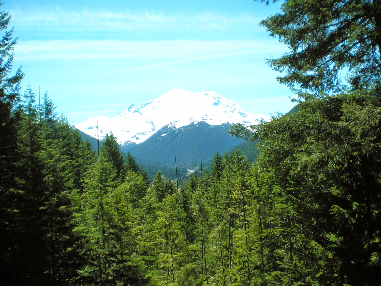
A view of Washington's Mt. Rainier (14,414') taken on 12 Jun 2012.
Natl Park Service website.
The highest peak in Oregon is Mt. Hood at 11,249'; I have no photo of it yet; see the 1st link below.

California's Mt Whitney (14,494') as seen from Inyo County's Portagee Joe Campground. For more info see the 2d entry in the Links below; it has an excellent photo on a National Park Service page called "Climbing Mt. Whtiney."

Nevada's Boundary Peak (13,147') as seen from US Hwy 6 not too far from Montgomery Pass.
More info.
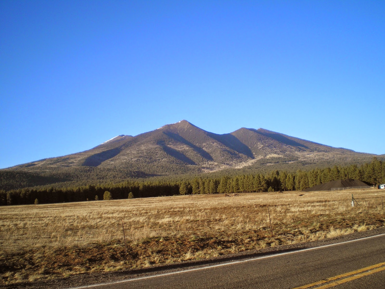
Arizona's Humphrey's Peak (12,637') in the San Francisco Mtns just north of Flagstaff.
See the 3d link below for more info.

New Mexico's Wheeler Peak (13,159') to the north-east of Taos.
More info.
I drove around the Ashley Natl Forest hoping for a clear view of Utah's Kings Peak (13,534'), but there was never a clear shot until I was back on the nearest highway. See the 4th link below for a good photo.
See 5th link below for a photo of Idaho's Borah Peak (12,662 or 12,668')
See the 6th link below for a photo of Colorado's Mt Elbert (14,440')
And Wyoming's Gannett Peak (13,809') is the 7th link below.

Montana's Granite Peak (12,807') as seen from the Beartooth Highway.
More info.

Guadalupe Mtn (8,751'), TX, in Guadalupe Mtns Natl Park.

While reading my 2008 World Almanac I noted Mt Harney, the highest point in South Dakota and realized I had a photo of it taken after I visited Mt. Rushmore. See Link #8 below for more info.
[Return to the top of the page]
Links:
- Wikipedia article on Mt. Hood, OR
- Climbing Mt. Whitney
- Wikipedia article on Arizona's Humphrey's Peak
- Wikipedia article Utah's Kings Peak
- Wikipedia article on Idaho's Borah Peak
- Wikipedia article on Colorado's Mt Elbert
- Wikipedia article on Wyoming's Gannett Peak
- Wikipedia article on South Dakota's Harney Peak
- Wikipedia article on North Dakota's White Butte
- Wikipedia article on Hawkeye Point
- Wikipedia article on Taum Sauk Mountain
- My Clayton Lake, NM, to Black Mesa, OK, post on 14 May 2013; 5th photo is of Black Mesa
- Wikipedia list of states by elevation
- 20 Sep 2014 post titled Updated State High Points
Routes:
M 27 Apr Actual Route: I-10 Rest Area - Live Oak Lib - P.O. - Walmart
T 28 Apr Actual Route: Live Oak Walmart - Lowe's - Live Oak W/M
W 29 Apr Actual Route: Live Oak Walmart - Lowe's - Gainesville, FL, VA Hosp - Walmart
Th 30 Apr Actual Route: Live Oak Walmart - VA Hosp - Ocala I-75 Rest Area
F 1 May Actual Route: Ocala I-75 Rest Area - Inverness Lib - Floral City Lib - Lutz Walmart
Sa 2 May Actual Route: Lutz W/M - Lutz Br Lib - Walmart
Su 3 May Actual Route: Lutz W/M - Lutz Br Lib - Sarasota Walmart
M 4 May Actual Route: Sarasota W/M - North Port, FL, W/M
T 5 May Actual Route: North Port W/M - North Port Br Lib - Punta Gorda Lib - Naples W/M
W 6 May Actual Route: Naples W/M - Naples McDs - Monroe Jcn - Homestead Hm Depot
Th 7 May Route: Homestead Hm Depot - MurphyUSA Gas - Key Largo - Homestead
Finding Campgrounds:
- RV Campgrounds from TrailerLifeDirectory.com
- Family Camping Directories from Woodalls.com
- Free campsites website
- Info on finding BLM Campgrounds


