Wednesday, July 31, 2013

Colorado National Monument

Colorado National Monument

Eagle Library, Colorado

    Approximately 2,000 ft. above the junction of the Gunnison and Colorado Rivers lies a national monument which is similar to several nation parks or monuments in Utah -- especially Zion National Park. The water you see is the Colorado below its confluence with the Gunnison. [Photos taken on 13 & 14 Aug.]


    Panning right we see more of "The Grand Valley," as the area around Grand Junction is known.


    Though Grand Junction is a city of c50,000 people, there are still several vacant areas into which it could expand.


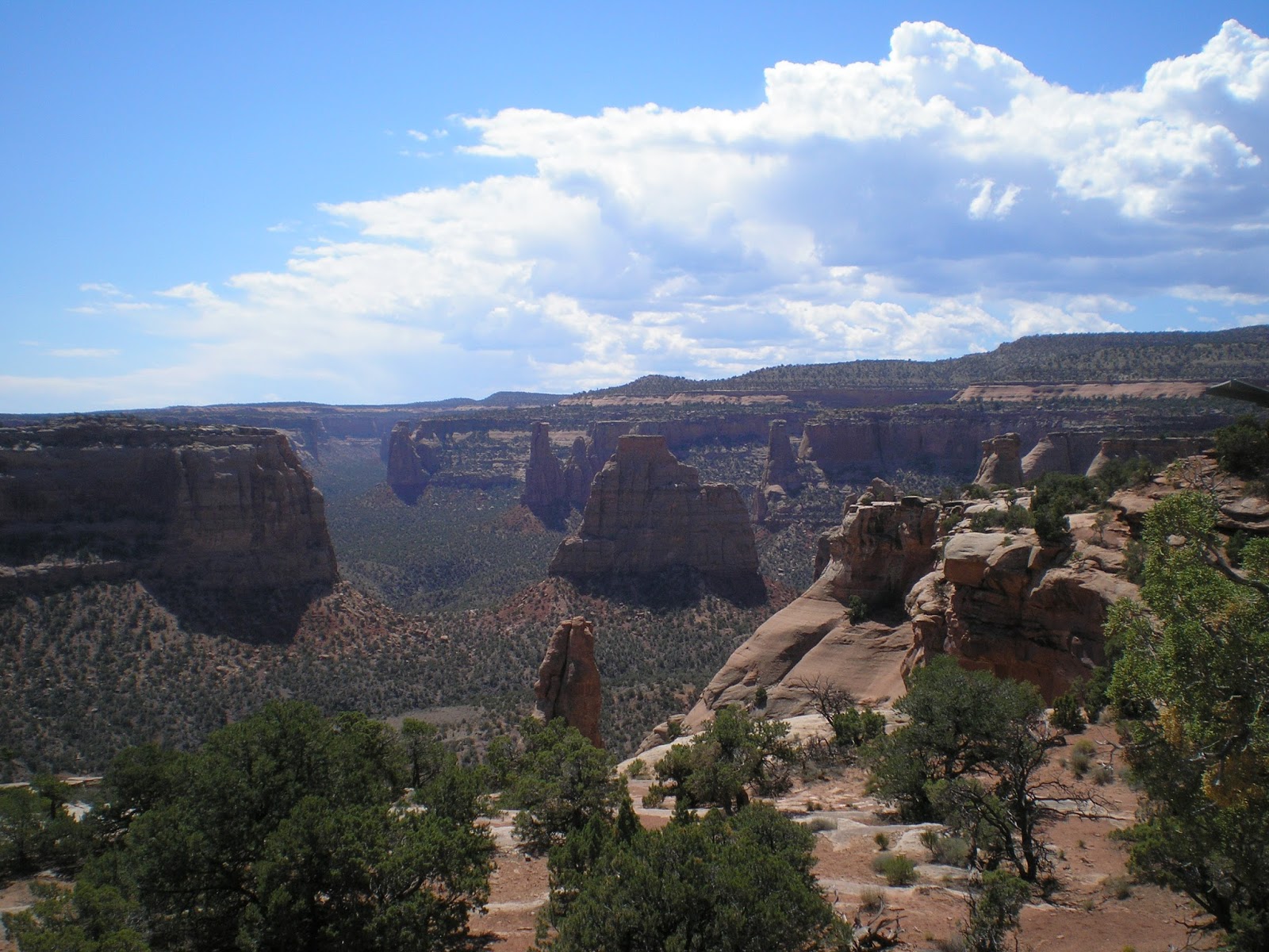
    Panning right again from the "Redlands View" from just under 5,000 ft.


    [Click once to enlarge; press ESC to return here.]The Redlands Fault had shaped the land here with many strong earthquakes.


    Another plaque explaining the importance of the Redlands Fault.


    Another look at the red in the Redlands Fault.


    A view up the Fruita Canyon.


    A plaque with a photo of the rather narrow trail to the top of the mesa where there was water and grass. Wonder how many head fell off of the trail and became a meal for coyotes, vultures, etc.?


    While I thought I saw the former cattle "driveway" before I took this photo, I don't see it now.


    Though I didn't see them there are apparently houses at Glade Park.


    The many estuaries and ponds along the Colorado River to the west of Grand Junction.


    A shot of Wedding Canyon from Book Cliffs View.


    Zooming in on the "Pipe Organ."


    Like such other national parks and monuments on the Colorado Plateau as Zion, Capitol Reef, Bryce, and the Grand Canyon, Erosion, with a capital E, is the key to these formations. Over time, wind, rain, snow, and ice wear away the sharp edges.


    Often a layer of harder rock is left as a capstone atop a pedestal of softer rock.


    Zooming in on Independence Monument, which was first climbed by John Otto, who first came to this area in 1907 and felt it should be a national park.It became a National Monument in 1911.


    [Click once to enlarge; press ESC to return here.] Afraid of heights? Not these climbers, who repeat John Otto's raising of Old Glory each Independence Day.


    As seen from Grand View, believe the formation in the center is called "Kissing Couple."


    As this plaque indicates the building of 23-mile Rim Rock drive from the West (Fruita) Entrance/Exit to the West (Grand Jcn) Entrance/Exit did cost some loss of life. Nine workers were killed in 1933 (no indication if they were CCC workers) and two more men also perished.


    As this plaque mentions early monument visitors said one formation looked like coke ovens, which were used particularly near mines to convert coal to a nearly-gasless fuel, coke.


    The Coke Ovens as seen from their so-named Overlook.


    Carry water if you're hiking through this area -- even if you're going downhill!


    Not sure if this is Black Ridge, but the city of Grand Junction would be tough to reach via phone without out these towers.


    I warned a couple arriving just as I left to beware of the trick question on swimming pools. The woman said, "How refreshing," as it was becoming increasingly hotter. This plaque & dry potholes is what I found after a 75-yard walk.


    An Eqyptian Pharaoh's Tomb?


    From the top of Red Rock Canyon looking out on the grand Valley.


Return to Top of Page

Th 15 Aug Actual Route: Montrose Walmart - Black Canyon of the Gunnison Natl Pk

F 16 Aug Actual Route: Black Canyon of the Gunnison Natl Pk - Curecanti Natl Rec Area CG

Sa 17 Aug Actual Route: Curecanti NRA CG - Gunnison Lib - Crested Butte bd

Su 18 Aug Actual Route: Crested Butte bd - Carbondale - Glenwood Springs Walmart

M 19 Aug Actual Route: Glenwood Springs W/M - Glenwood Sprs Lib - Carbondale Lib - Glenwood Springs W/M

T 20 Aug Actual Route: Glenwood Springs W/M - Glenwood Sprs McDs - Gypsum Lib - Eagle Lib - US6 bd

W 21 Aug Actual Route: US6 bd - Eagle Lib - Brush Crk Rd bd

Th 22 Aug Actual Route: Brush Crk Rd bd - Eagle Lib - Avon Starbucks - Avon Walmart

F 23 Aug Actual Route: Avon Walmart - Leadville USFS District Office - Lib - Twin Lakes CG

Sa 24 Aug Actual Route: Twin Lakes CG - Buena Vista P.O. - Lib - Cottonwood Pass Rd bd

Su 25 Aug Route: Cottonwood Pass Rd bd - Buena Vista Lib - Valley MHP & RV CG


Finding Campgrounds:

N.B. I receive nothing from Trailer Life, Woodalls, or FreeCampsites.net for including links to their free campground lookups.

Saturday, July 27, 2013

How I Find Free WiFi

How I Find Free WiFi

[Last Revised: 22 Aug 2013]

Elk Creek CG, Curecanti Natl Rec Area, CO
    During the last 33 months of travel initially on the west coast and now in Texas and the Rockies I only briefly had a working cell phone. Otherwise I've depended on finding free WiFi both to communicate with relatives and update this blog.

    Since libraries are most likely to have WiFi I often look up the website of the next county seat's library along my planned route. But if I neglect to do that, there are four national chains from which either to look up a library or each other. Here are The Big Four.

  • McDonalds
  • Starbucks
  • HomeDepot
  • Lowe's

    While Lowe's has the strongest WiFi, mainly because that's needed to cover their large parking lots, I've listed McDonalds first since one often sees their billboards when approaching a new town or city.
    Also, you can sometimes see the "Golden Arches" in case you missed their billboard.

    While Starbucks parking lots are often crowded around noon and again in the evening and they usually have two handicapped parking spots in front of their stores, their WiFi is usually as strong as McD's, if not stronger.

    While I've used HomeDepot's WiFi the least of the four, their large buildings sometimes have parking alongside where one can avoid parking in the hot sun.
--
    Prior to some point in 2012 one could download a list of all of a state's McDonalds restaurants with WiFi by clicking on "Find WiFi Hotspots" on their homepage.
    Now, however, if one wants such a list, he has to "roll his own" by looking up restaurants with WiFi at the following link and then saving them to a text file.
....
http://www.mcdonalds.com/us/en/services/free_wifi.html
....

    While I've not made such lists for the other members of "The Big Four," I sometimes look them up ahead of time if I'm headed for a city which is large geographically.

--

    But there are substitutes for the Big Four which I'll call the "Big Four Subs." They include the following.
  • Visitor Information Centers
  • Some Grocery Store Chains
  • Senior Centers
  • Some Regional & National Restaurant Chains
  • Some Hotels & Motels

    I was told at Judge Roy Bean's Visitor Center in Langtry, Texas, that all of their Vistor Centers have WiFi. Colorado's Ft Collins Visitor/Info Center had a desktop one could use for 20-30 min but no WiFi for my laptop. Utah's Visitor Center at Dinosaur Rd and US40 had WiFi, but I only learned that by asking -- which is what I suggest you do when you stop at a Visitor Info Ctr in any state.

    Safeway is the dominant grocery store chain in California and on the west coast. Their stores built or remodeled in the last 6-7 years usually have WiFi -- especially if they have a Starbucks counter/kiosk in the store. Ditto for their Vons stores in Southern Calif. & Arizona.(It may be that Albertsons stores with Starbuck counters or kiosks also have WiFi.) Finally, only about 5% of Safeway/Vons' stores have 110v a.c.; if, like me your laptop battery is nearly comatose, you'll have to look elsewhere.

    The advantage of Senior Centers is that you're just as likely to find them in a small town as in a bigger city. For instance, I've used the Baggs Senior Ctr WiFi twice while they were closed. Of course, you may have to "come in through the back door" by logging onto their router, usually Linksys or NetGear. In both Grand Coulee, WA, & Kemmerer, CO, I didn't use their WiFi but asked them where the library was.

    While I have gotten on-line while parked outside a Wendys, Burger King, Dennys, Hardees, WhatABurger, & Golden Chick, I don't believe any of those have a policy of WiFi at every restaurant except perhaps Dennys.

    The last two are chains in Texas or the southeast where the franchisee decides whether or not to offer free WiFi.

    A contractor named Tim Kelly, whom I met in Las Cruces, NM, told me about the WiFi at HomeDepot & Lowe's. He also pointed out that not all motels or hotels have passcodes. [In fact, recently I parked behind one to get the address of the Gunnison, CO, Library; then I used Mapquest to find my way there.]


A Few Words about Libraries

    It would be convenient if all libraries left their WiFi's on 24/7 and did not use passcodes. But, skinflint that I am, I would likewise turn the routers off when the library closed if I were the librarian.

    And why is it that the smaller towns have libraries with passcodes whereas libraries of larger cities rarely use them? As I told the librarian at the Big Pine, TX, library, "You would think the libraries in larger cities have more secrets to hide than do those in small towns." And why is it that I arrive in small towns with closed libraries which have passcode-protected WiFi on Sundays when some big-city libraries are open?


    Do you have corrections, suggestions, or additions? Send them to my Hotmail e-mail address and after I check them out I shall add them to this article giving you credit. Especially want to find more companies like "The Big Four."
Links:
Return to Top of Page

T 13 Aug Actual Route: Walmart - VA Med Ctr - Grand Jcn Lowe's - Colo Natl Monument CG

W 14 Aug Actual Route: Colo Natl Mon CG - Grand Jcn - Delta Lib - Montrose Walmart

Th 15 Aug Actual Route: Montrose Walmart - Black Canyon of the Gunnison Natl Pk

F 16 Aug Actual Route: Black Canyon of the Gunnison Natl Pk - Curecanti Natl Rec Area CG

Sa 17 Aug Actual Route: Curecanti NRA CG - Gunnison Lib - Crested Butte bd

Su 18 Aug Actual Route: Crested Butte bd - Carbondale - Glenwood Springs Walmart

M 19 Aug Actual Route: Glenwood Springs W/M - Glenwood Sprs Lib - Carbondale Lib - Glenwood Springs W/M

T 20 Aug Actual Route: Glenwood Springs W/M - Glenwood Sprs McDs - Gypsum Lib - Eagle Lib - US6 bd

W 21 Aug Route: US6 bd - Eagle Lib - US6 bd


Finding Campgrounds:

N.B. I receive nothing from Trailer Life, Woodalls, or FreeCampsites.net for including links to their free campground lookups.

Wednesday, July 24, 2013

Glacier National Park - Part I

Glacier National Park, Montana - Part I

Louisville Library, Colorado

    The first of two large lakes along the Going-to-the-Sun Road just inside the west entrance to Glacier Natl Park at 3153 ft. Waterton Lakes National Park in Canada and Glacier Park in Montana have formed Waterton-Glacier International Peace Park since 1932.


    [Click once to enlarge; press ESC to return here.] A plaque on the Robert fire, which started outside of the park on 23 Jul and spread into the park, burning until 8 Sep when nearly an inch of rain & snow finally ended its spread.


    Another view toward the outlet of Lake McDonald, which is 11? miles long.


    Yet another view toward the west end of the lake, where the Apgar Visitor/Transit Center is located.


    A look up the Lake McDonald inlet stream, McDonald Creek. Not sure whether the peak is Heavens Peak (8987') or Mt. Oberlin (8180').


    Looking down McDonald Creek from where the previous photo was taken.


    A shot down McDonald Falls.


    A view up McDonald Creek from McDonald Falls.


    Perhaps this is Heavens Peak. But it was taken from in front of a restroom where I met a couple from Alberta, Dave & Lori, who were headed for their cabin on Swan Lake in Montana.


    Perhaps this is Avalanche Creek. But one thing is certain -- that this was one of the last straight stretches of road, for the climb to Logan Pass was not far ahead.


    Longfellow Peak? (8904') from "The Loop," where the "Going-to-the-Sun" stops following McDonald Creek and does a 180 to head for Logan Pass.


    From the Loop at 4300' a shot of the Lewis Range, which includes many glaciers.


    One of the more interesting plaques which explains why National Park Service Director Stephen Mather chose a more expensive but more picturesque route to Logan Pass. [Click once to enlarge; press ESC to return here.]


[More photos to follow in Part II once I get to the Gunnison, CO, Lib


Links:
Return to Top of Page

F 9 Aug Actual Route: Craig W/M - Craig Lib - Craig P.O. - Craig W/M

Sa 10 Aug Actual Route: Craig W/M - Craig Lib - McDs - Meeker, CO - Rifle Colo Rest Area - Walmart

Su 11 Aug Actual Route: Walmart - Rifle Lib - Walmart

M 12 Aug Actual Route: Walmart - Parachute Br Lib - Grand Jcn Walmart

T 13 Aug Actual Route: Walmart - VA Med Ctr - Grand Jcn Lowe's - Colo Natl Monument CG

W 14 Aug Actual Route: Colo Natl Mon CG - Grand Jcn - Delta Lib - Montrose Walmart

Th 15 Aug Actual Route: Montrose Walmart - Black Canyon of the Gunnison Natl Pk

F 16 Aug Actual Route: Black Canyon of the Gunnison Natl Pk - Curecanti Natl Rec Area CG

Sa 17 Aug Actual Route: Curecanti NRA CG - Gunnison Lib - Crested Butte bd

Su 18 Aug Actual Route: Crested Butte bd - Carbondale - Glenwood Springs Walmart

M 18 Aug Route: Glenwood Springs W/M - Glenwood Sprs Lib - Carbondale Lib


Finding Campgrounds:

N.B. I receive nothing from Trailer Life, Woodalls, or FreeCampsites.net for including links to their free campground lookups.

Sunday, July 21, 2013

Seeley Lake to Swan Lake, Montana

Seeley Lake to Swan Lake, Montana

Rifle, Colorado, Library


    Recall that on 3 July I drove from Stevensville, MT, where I had been visiting a classmate & her husband, to Seeley Lake, where most of the campgrounds were already full. Tried Plan B: drive a USFS road until you find a level spot to park -- which I did on top of a ridge.


    While a few vehicles did drive by, including a small USFS pickup, there was little traffic -- mainly because the road is narrow -- too narrow for anything bigger than a truck camper like mine; in fact, I worried about meeting someone while driving back to Seeley Lake since the vehicle traveling downhill is supposed to back up, something that often causes me difficulty.


    As you can see starting with the above photo, I walked around the mixed lodgepole pine/Douglas fir forest looking for wildflowers to photograph.
    Unfortunately I can't identify most of the flowers since they aren't in my Sierra Nevada natural history book by Usinger and Storer.


    While the 3-petal flower above is similar to the trillium, which I saw for the first time in Mt. Ranier Natl Park, it also reminds me of the Mariposa Lily, which is common in the upper Sierra Nevada foothills in Calif.
    The flower to the right reminds me of the Foxgloves at a cousin's spread north of Ft Bragg, Calif.


    The upper end of Seeley Lake from near where I parked my rig on the ridgetop.


    Sunflowers come in all shapes and sizes.


    Some sort of rose -- or relative? And note the buds for some type of berry in the foreground.


    Some type of berry based upon its spines.


    Since several vehicles drove by later on the 4th, I decided to drive up the road, hoping it would take me back to MT83. No such luck as it climbed higher and higher, but I did get some views of nearby mountains including this one.


    Another view, though from a somewhat lower elevation, of the same mountains.


    One final look at the same mountaintops.


    Back on MT83 and headed for Kalispel; this is Swan Lake.


    Hoping for a massive wipe-out, I finally gave up and photographed one of several water skiers.


    Panning right....


    Looking toward the upper end of the lake it's clear that Swan Lake is a long one.


    A sign which bills Swan Lake as the longest [in the U.S.?] without a dam; it is 10 miles long and 1 mile wide.


Links:
Return to Top of Page

Su 4 Aug Actual Route: RV World CG - McDs - Tom Neuman Truck & RV - Rawlins, WY bd

M 5 Aug Actual Route: RV World CG - McDs - Tom Neuman Truck & RV - Rawlins bd

T 6 Aug Actual Route: Rawlins bd - Rawlins Lib - Tom Neuman Truck & RV - Rawlins bd

W 7 Aug Actual Route: Rawlins bd - Rawlins Lib - Baggs Sr Ctr - CO13 bd

Th 8 Aug Actual Route: CO13 bd - Craig, CO, Lib - Dollar Tree - Craig Walmart

F 9 Aug Actual Route: Craig W/M - Craig Lib - Craig P.O. - Craig W/M

Sa 10 Aug Actual Route: Craig W/M - Craig Lib - McDs - Meeker, CO - Rifle Colo Rest Area - Walmart

Su 11 Aug Actual Route: Walmart - Rifle Lib - Walmart

M 12 Aug Actual Route: Walmart - Parachute Br Lib - Grand Jcn Walmart

T 13 Aug Actual Route: Walmart - VA Med Ctr - Grand Jcn Lowe's - Colo Natl Monument CG

W 14 Aug Route: Colo Natl Mon CG - Grand Jcn - Delta Lib - Montrose Walmart

Th 15 Aug Route: Montrose Walmart - Black Canyon of the Gunnison Natl Pk


Finding Campgrounds:

N.B. I receive nothing from Trailer Life, Woodalls, or FreeCampsites.net for including links to their free campground lookups.