Wednesday, August 29, 2012

Pinecrest & Lyons Lakes, California

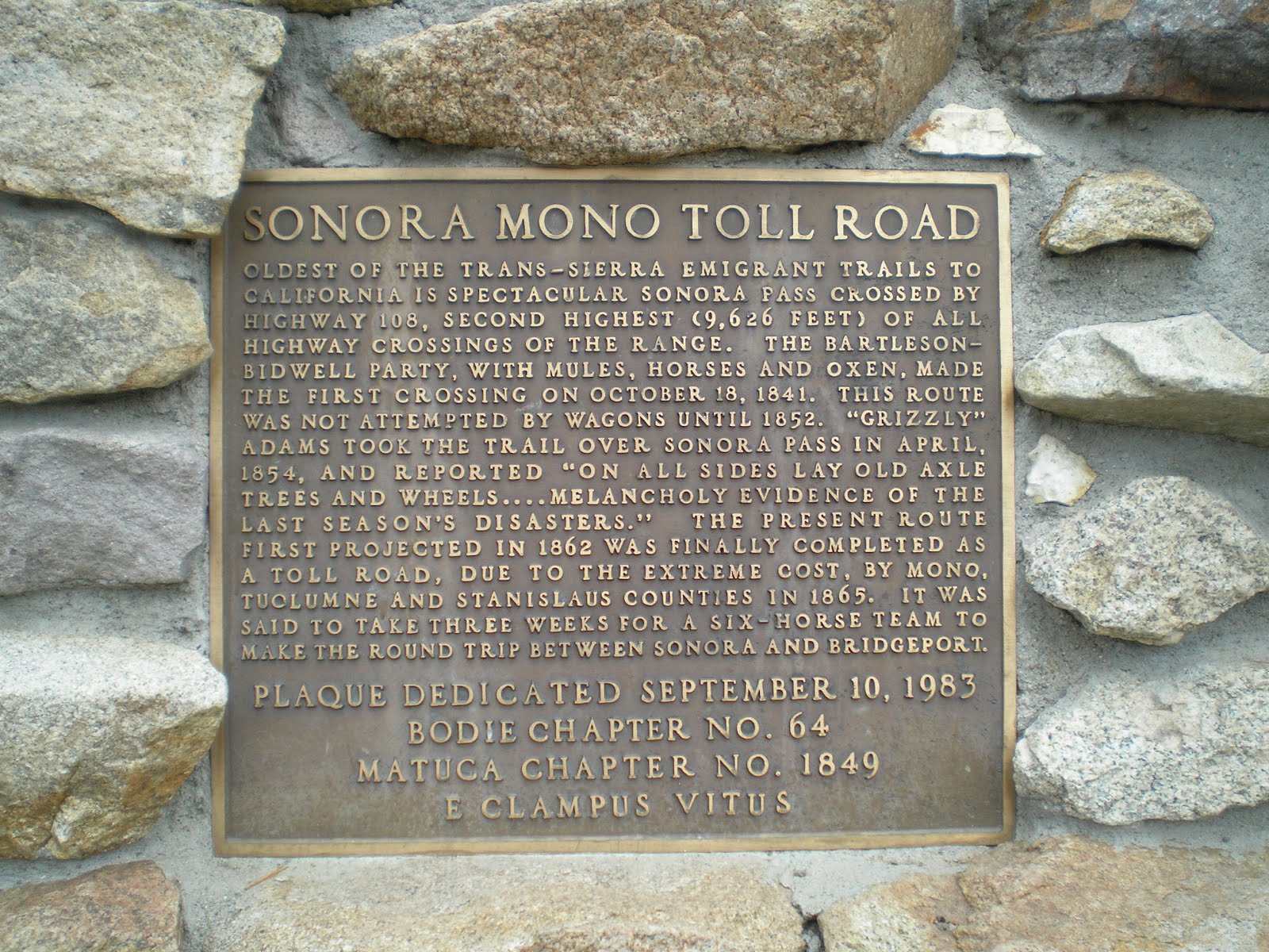
Mi-Wuk Village Library*, CA

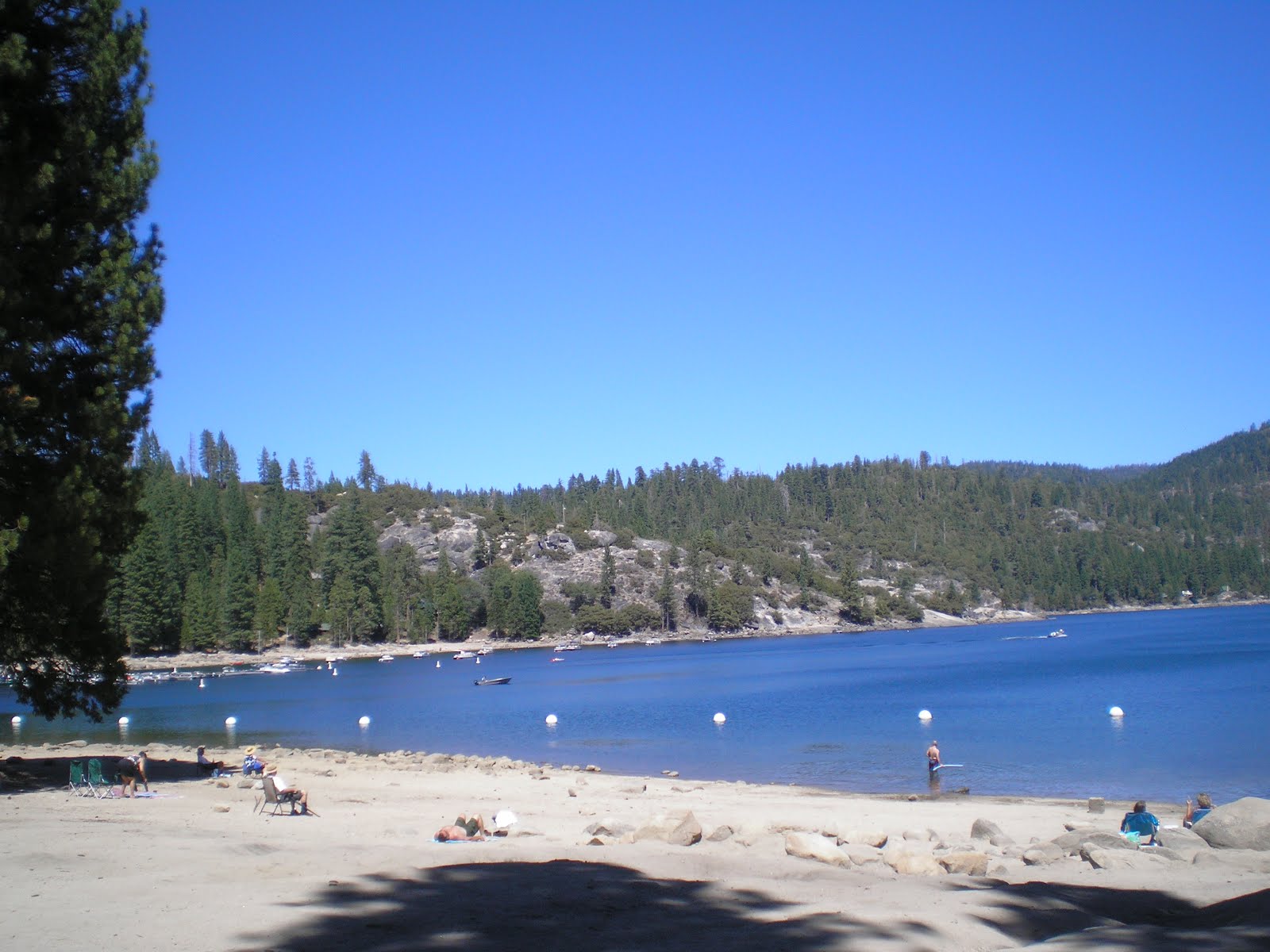
    Looking across Pinecrest Lake on the South Fork of the Stanislaus River at Pinecrest Peak (elev: c8460'), which formerly was capped by a U.S. Forest Service Lookout.     The road to the former lookout provided, and presumably still does, access to Herring Creek as well as trails to Waterhouse Lake and Copper's Meadow.


    Panning right one see no yachts but rather many small sailboats and a few other types of watercrafts.
    There is a trail, titled the Pinecrest National[?] Recreation Trail, which circumnavigates the lake, crossing the dam and a bridge over the S.F. of the Stanislaus. I walked paart of it to the right past the boats.


    Incidentally, no dogs are allowed on the sandy beaches but they are allowed on the trails if they are leashed.


    [Click once to enlarge; press ESC to return here.] PG&E plans to work with the USFS to meet the requirements of the ADA [American with Disabilities Act].


    Taken from what may be the fishing platform in the above plaque; however, with the dryer than normal winter, the lake is abnormally low.


    Looking to the right, a few more boats as well as the roof of one of the many houses which are prevalent on the more-forested south-east side of the lake.
    One house, apparently in jest, had a sign which said "Bear Hibernation Station." Another dry winter and the sign may have to be changed to "Bear Feeding Station."


    One can see the three beaches mentioned on the plaque. The fellow working the desk at the Summit District Ranger Station told me that the Pincrest Lodge was taken down sometime in the 1970s. Since I worked at the RS during the summer of 1960, I vaguely recall that lodge. All of my trips thereafter were up the Dodge Ridge Road, missing the crowds at the lake.


    A view across the lake to just left of the dam. There only appear to be a couple of boats involved in fishing.


    Hoped I had walked far enought up the lake to get a shot of the dam, but not so. It's "just around the corner" beneath the rocky outcroppings in the middle of the photo.


    Panning right, one can see the white roof of a cabin, which is likely only accessible via foot along the trail or via boat.
--


    A road just past the Lyons Dam Road seemed like a good spot to get a photo of Lyons Lake from an adjacent ridge. So I parked on the old roadbed of CA108 and walked Lakeview Drive.
    Because of all of the trees I was unable to get more than a bried glance of the lake. So I drove the 2 miles down to it, where I photographed this sign.


    Lyons Lake has long been the water source for the town of Tuolumne, formerly the home of the West Side Lumber Company.
    Here's a view of Lyons Dam.


    Like Pinecrest Lake, Lyons Lake is also on the South Fork of the Stanislaus River.


    Panning right again one can see that the lake's level is low. Unlike Pinecrest, only a few fishermen frequent Lyons Lake; also, the road to Pinecrest Lake is paved while the Lyons Dam Road is a sometimes rough gravel road.


    The inlet to the lake is directly above the partially-submerged stump.


    Here's the remainder of what is a rather small man-made lake.
--


Links:


--
*Mi-Wuk Village Library's WiFi operates 24/7; there is parking in front of their building for RVs of moderate size, but not Class A's, especially with toads.
--

T 28 Aug Actual Route: 1 mi E of N.F. Tuolumne Riv bd - Sonora - Twain Harte - 1 mi E of N.F. Tuolumne Riv bd

W 29 Aug Actual Route: 1 mi E of N.F. Tuolumne Riv bd - Pinecrest - Mi-Wuk Village - 1 mi E of N.F. Tuolumne Riv bd

Th 30 Aug Actual Route: 1 mi E of N.F. Tuolumne Riv bd - Twain Harte - Sonora - Mi-Wuk Village - 1 mi E of N.F. Tuolumne Riv bd

F 31 Aug Actual Route: 1 mi E of N.F. Tuolumne Riv bd - Lyons Dam/Lake - Mi-Wuk Village - 1 mi E of N.F. Tuolumne Riv bd

Sa 1 Sep Route: 1 mi E of N.F. Tuolumne Riv bd - Sonora - Wi-Wuk Village - 1 mi E of N.F. Tuolumne Riv bd

--

Finding Campgrounds:

N.B. I receive nothing from Trailer Life, Woodalls, or FreeCampsites.net for including links to their free campground lookups.

Friday, August 24, 2012

Twain Harte Lake, California

Mi-Wuk Village Library, CA


    In 1940 when my uncle, David Wilcoxson Jr, graduated from Summerville High School in Tuolumne his parents bought a lot at Twain Harte as his graduation present.


    Here's a shot through a chain-link fence of part of the lake and the large rock which was at one end of the dam across an unnamed creek.     Of course, my grandmother Cordelia hung onto the pass which allowed property owners to use the lake. She often took either nieces and nephews or her grandkids to Twain Harte on days when the Tuolumne Plunge was closed.

    I walked down the parking lot to the gate and asked the woman working there if I might take a photo. She assented and I took the photo to the right as well as the following photo. I talked with her for a while and she said that she had been coming to Twain Harte for nearly 60 years -- which means she may have been here when Cordelia Wilcoxson, who believed kids should be able to swim every day during the summer, showed up with her five grandkids.
    The gatekeeper said nothing much had changed in 60 years. I replied that the flags were not on the rock back then but otherwise the lake looked the same.


    Panning left one can see why dogs are not permitted inside the fence: nice white sand in which to bury a nasty surprise!     Up the creek there's a golf course. Wonder if my brother-in-law Phil has played it?
--
Links:


--
*Mi-Wuk Village Library leaves its WiFi on 24/7; there is parking in front of it for moderate-size RVs, but not Class A's with toads. --

F 24 Aug Actual Route: 1 mi E of N.F. Tuolumne Riv bd - Sonora - 1 mi E of N.F. Tuolumne Riv bd

Sa 25 Aug Actual Route: 1 mi E of N.F. Tuolumne Riv bd - Sonora - 1 mi E of N.F. Tuolumne Riv bd

Su 26 Aug Actual Route: 1 mi E of N.F. Tuolumne Riv bd - Sonora - Don Pedro T - Modesto Reservoir CG

M 27 Aug Actual Route: Modesto Reservoir CG - Waterford - Modesto - Riverbank - Oakdale - MiWuk Village - 1 mi E of N.F. Tuolumne Riv bd

T 28 Aug Actual Route: 1 mi E of N.F. Tuolumne Riv bd - Sonora - Twain Harte - 1 mi E of N.F. Tuolumne Riv bd

W 29 Aug Actual Route: 1 mi E of N.F. Tuolumne Riv bd - Pinecrest - Mi-Wuk Village - 1 mi E of N.F. Tuolumne Riv bd

Th 30 Aug Actual Route: 1 mi E of N.F. Tuolumne Riv bd - Twain Harte - Sonora - Mi-Wuk Village - 1 mi E of N.F. Tuolumne Riv bd

F 31 Aug Actual Route: 1 mi E of N.F. Tuolumne Riv bd - Lyons Dam/Lake - Mi-Wuk Village - 1 mi E of N.F. Tuolumne Riv bd

Sa 1 Sep Route: 1 mi E of N.F. Tuolumne Riv bd - Sonora - Wi-Wuk Village - 1 mi E of N.F. Tuolumne Riv bd

--

Finding Campgrounds:

N.B. I receive nothing from Trailer Life, Woodalls, or FreeCampsites.net for including links to their free campground lookups.

Friday, August 17, 2012

Capitol Reef National Park, Utah

Sonora Library, CA


    I visited Capitol Reef National Park in Utah on 5 April of this year; because the parking lot at the Visitor Center near Fruita was crowded, it's the only National Park or Monument for which I did not obtain a brochure.


    If you're wondering why so many of Utah's landmarks have flat tops, part of the reason is that they formed in the beds of ancient seas.


    The Capitol Reef is roughly 100 miles long. Because it was a barrier to western migration, some claim it was like a reef in the sea.


    Somewhere I believe I saw a plaque which said that miners in the area who had previously been seamen call the barrier a reef.


    Because many of the sandstone domes looked like that of the U.S. Capitol, the park's name became "Capitol Reef."
    The Fremont River, which flows east from the vicinity of Fruita, a former Mormon settlement.


    "Try driving your wagon up this, Sod-buster!"


    Utah state route 24.


    UT24 essentially follows the Fremont River.


    Somewhere along the road through Capitol Dome Reef Natl Park I remember taking photos of some petroglyphs -- but, apparently, not here.


    [Click once to enlarge; press ESC to return here.]


     Navaho Dome in the middle -- as explained in the above plaque.


    One of the orchards planted by Mormon settlers.


    The petroglyphs are just above the row of rocks at the right of center.


    Zooming in....


     The Fruita School House, which is explained in the following photo.


    [Click once to enlarge; press ESC to return here.]


    Click again.
--


Links:

T 21 Aug Actual Route: 1 mi E of N.F. Tuolumne Riv bd - Mi-Wuk Willage - Sonora - Mi-Wuk Village - 1 mi E of N.F. Tuolumne Riv bd

W 22 Aug Actual Route: 1 mi E of N.F. Tuolumne Riv bd - Mi-Wuk Willage - Sonora - Mi-Wuk Village - 1 mi E of N.F. Tuolumne Riv bd

Th 23 Aug Actual Route: 1 mi E of N.F. Tuolumne Riv bd - Sonora - 1 mi E of N.F. Tuolumne Riv bd

F 24 Aug Actual Route: 1 mi E of N.F. Tuolumne Riv bd - Sonora - 1 mi E of N.F. Tuolumne Riv bd

Sa 25 Aug Route: 1 mi E of N.F. Tuolumne Riv bd - Sonora - 1 mi E of N.F. Tuolumne Riv bd

Su 26 Aug Route: 1 mi E of N.F. Tuolumne Riv bd - Sonora - Waterford - Modesto Reservoir CG

--

Finding Campgrounds:

N.B. I receive nothing from Trailer Life, Woodalls, or FreeCampsites.net for including links to their free campground lookups.

Monday, August 13, 2012

Monitor Pass to Sonora Pass, CA

East of Long Barn, CA     Silver Creek, which CA4 follows on the east side of Ebbetts Pass. Looked in several holes, but couldn't spot fish of any size. However, once Silver Creek veers away from the highway, I suspect one can find more fish. It joins the East Fork of the Carson River, which joins other forks of the Carson in their journey to Lahontan Reservoir near Silver Springs, NV.


    The East Fork of the Carson downstream from its confluence with Wolf Creek.


    Since thunder-bumpers were in the forecast I stopped on the west side of Monitor Pass and took several photos.


    Panning left one can see that it's clear to the west and south.


    Note that there's virtually no snow left on the east side of the Sierra Nevada Mountain Range in the distance.


    Looking south the peaks seem to be getting higher, with elevations of 10-11,000 feet.


    Just over the top of Monitor Pass (elev: 8314') I took a photo of a couple of young "love-birds" with their camera and then took this shot looking south.


    Panning left one can barely see the top of the mountains just inside the Nevada border to the east because of the rain.


    Panning further left we see some green in the valley below as well as the aforementioned young couple taking photos of each other.


    Two miles east of the Marine Mountain Warfare Training Camp I parked at the same wide-out I used last fall after all of the USFS camps had closed for the season.     This is the West Walker River.


    The West Walker River a bit farther downstream. While I looked for rises several time, I never say any -- perhaps because I was simply too far away.


    While the White Mountains are farther south on the east side of the Owens Valley, the mountains in the distance, which are likely in Nevada, might also be called the White Mtns.


    From CA108 looking across Pickel Meadow toward what may be Matterhorn Peak on the crest of the Sierra Nevada.


    Zooming in, Sardine Falls is visible just above the trees. [Click one to enlarge; press ESC to return here.]


    At long last, a parking spot atop Sonora Pass (elev:9634')-- though I chose a spot a bit down the western side.


    [Click once to enlarge; press ESC to return here.] I see to have forgotten that the original Sonora Mono Toll Road when up the Clark Fork of the Stanislaus River.


    Enlarge to read another history of the Sonora Toll Road.


    I drove to the end of the Clark Fork [of the Stanislaus] Road to get a photo of the dominant monolith at Iceberg Meadows: the Iceberg. The photo thru the pines & cedars is about a quarter mile up the Disaster Creek Trail.


    At about the 3/8 mi point up the Disaster Crk Trail I got a somewhat better photo. However, hunger pains & weak leg muscles caused me to head back to my camper.


    While eating lunch I realized that there is a clear view of the Iceberg across the meadow. Here's a shot of the meadow, which is private property; you can see the base of the Berg just above the trees.


    The Iceberg.


    There was much fallen timber on the LDS Liahontan property next to the Arnot Creek Trailhead.


    Information on the Carson-Iceberg Wilderness in the headwaters of the Stanislaus and Mokulumne Rivers.
--


Links:

  • Links to follow shortly.

--

Th 16 Aug Actual Route: 1 mi E of N.F. Tuolumne Riv bd - Mi-Wuk Willage - Sonora - Mi-Wuk Village - 1 mi E of N.F. Tuolumne Riv bd

F 17 Aug Actual Route: 1 mi E of N.F. Tuolumne Riv bd - Mi-Wuk Willage - Sonora - Mi-Wuk Village - 1 mi E of N.F. Tuolumne Riv bd

Sa 18 Aug Actual Route: 1 mi E of N.F. Tuolumne Riv bd - Mi-Wuk Willage - Tuolumne - Sonora - Mi-Wuk Village - 1 mi E of N.F. Tuolumne Riv bd

Su 19 Aug Actual Route: 1 mi E of N.F. Tuolumne Riv bd - Mi-Wuk Willage - 1 mi E of N.F. Tuolumne Riv bd

M 20 Aug Route: 1 mi E of N.F. Tuolumne Riv bd - Mi-Wuk Willage - 1 mi E of N.F. Tuolumne Riv bd

--

Finding Campgrounds:

N.B. I receive nothing from Trailer Life, Woodalls, or FreeCampsites.net for including links to their free campground lookups.