Sunday, August 28, 2011

Napa to Pleasant Hill to Mt Diablo

Palo Alto, CA


    A first look to the west from under my hat during the late afternoon on Sa 27 Aug at approximately the 1000' level on Mt Diablo.


    A view toward the north-west and the area around Benecia and Martinez.


    The 3d, 4th, & 5th shots were all taken from the approximately same location at the Junction Campground looking toward the lower end of the San Ramon Valley and the Livermore Valley. This view was at about 7 p.m. on Saturday evening.


    [Click 1 or 2 time to enlarge, particularly the nearly-black photo taken at 9:00 P.M.]


    A you can see from this photo taken at c8 a.m. most of the vallies are enveloped in fog.


    As I snapped this photo a biker pulled his bike away from the plaque; however, I neglected to see if the photo was level.


    If you've ever used older USGS maps, you may have notice a "Mount Diablo Baseline" not on their bottoms.


    Mt Diablo is just a mere 151' short of 4,000'. As the bottom sign says, you can indeed stand on the very top of the mountain -- thanks to the work of the Civilian Conservation Corps in the 30s and 40s.


    If enough people stand on the peak's top, it may, over time, lose some of its height.


    While there is manzanita in the Santa Cruz Mountains it is apparently not common manzanita.


    A better view of the area surrounding Benicia and Martinez.


    The San Ramon and still-fogged-in Livermore Vallies.


    Prominent peaks are often "decorated" by microwave towers -- and Mount Diablo is the most prominent peak outside of Mt. Kilamanjaro in Africa.


    Hey! The earth is curved!


--
Links:

Su 28 Aug Actual Route: Mt Diablo SP - Livermore - Tesla Rd

M 29 Aug Actual Route: Tesla Rd - Livermore - Milpitas - Palo Alto VA Hospital

T 30 Aug Actual Route: Palo Alto VA Hospital - Palo Alto - Palo Alto VA Hosp

W 31 Aug Actual Route: Palo Alto VA Hosp - Santa Cruz - Pinto Lake CG

Th 1 Sep Actual Route: Pinto Lake - Aptos - Santa Cruz - Pinto Lake

F 2 Sep Actual Route: Pinto Lake - Castroville - Marina - Santa Cruz - Palo Alto VA Hosp

Sa 3 Sep Route: Palo Alto VA Hosp - Palo Alto - Mountain View - Palo Alto VA Hosp

Su 4 Sep Route: Palo Alto VA Hosp - Portola Valley - Half Moon Bay
--
Finding Campgrounds:

N.B. I receive nothing from Trailer Life or Woodalls for including links to their free campground lookups.

Friday, August 26, 2011

Petaluma to Sonoma to Napa

Skyline RV Park, Napa, CA


    Jack and Ruth Lanfear [SCHS, '57] in the front yard of their Petaluma home.


    A plaque placed on the Blue Wing Inn by the Native Sons of the Golden West in Oct 1841; among the U.S. Army generals who stayed there were U.S. Grant, William Sherman, and Phil Sheridan. Among the banditos who stayed there were Joaquin Murietta and "Three-Fingered Jack." ["Bird of a feather...."]


    The Blue Wing Inn, which is directly across Spain Street from the last and northern-most mission, Mission San Francisco Solano.


    The above-mentioned mission and the last of the 21-mission chain started by Fr. Junipero Serra, who was buried at the Carmel mission.


    The "front porch" (though in Spanish it likely has another name) of the Solano Mission.


    California Historical Marker #3, originally placed by the Native Sons of the Golden West in 1926.


    Another view of the Solano Mission at the north-east corner of Spain and First Streets in Sonoma.


    A plaque commemorating the raising of the Bear Flag on 17 June 1846 by the Bear Flag Party. Supposedly the monument is in the exact sport where the flag was raised.


    A larger, more elaborate monument to the Bear Flag Revolt, which eventually led to statwhood.


    In case you can't read the inscription on the large Bear Flag Revolt Monument, here's how it reads: "This monument was created by the Native Sons of the Golden West and the State of California to commemorate the raising of the Bear Flag on this spot June 14 1846 by the Bear Flag Party and their declaration of freedom of Califronia from Mexican rule. On July 9 1846 the Bear Flag was hauled down and the American Flag here raised in its place by Lieutenant Joseph W. Rewere, USA, who had been sent to Sonoma by Commander John B. Montgomery of the U.S. Sloop of War "Portsmouth" following the raising of the American Flag at Monterey July 7 1846 by Commadore John Drake Sloat."


    Sonoma's former Carnegia Library, which is used by the Chamber of Commerce Visitors Bureau.


    The Sonoma City hall at 2:35 in the afternoon. [Gee -- the clock is still working.]


--
Links:

Sa 27 Aug Actual Route: Napa - Pleasant Hill - Mt Diablo State Park

Su 28 Aug Actual Route: Mt Diablo SP - Livermore - Tesla Rd

M 29 Aug Actual Route: Tesla Rd - Livermore - Milpitas - Palo Alto VA Hospital

T 30 Aug Route: Palo Alto VA Hospital - Palo Alto - Palo Alto VA Hosp

W 31 Aug Route: Palo Alto VA Hosp - Santa Cruz - Pinto Lake CG
--
Finding Campgrounds:

N.B. I receive nothing from Trailer Life or Woodalls for including links to their free campground lookups.

Thursday, August 25, 2011

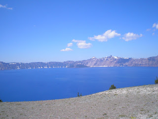
Virtual Tour of Crater Lake National Park

Guerneville, CA

    I visited Crater Lake National Park on 29 & 30 July, approaching from Klamath Falls along US97. Because I took no photos yesterday on my drive from Lake Sonoma to Healdsburg to Guerneville, decided to post the many photos I took on my way to, through, around, and from Crater Lake as a "Virtual Tour" of one of the most scenic parks in Oregon.

    I hope to add IDs of such park features as Wizard Island, the Phantom Ship, among others, and then describe the miserable night I and another ROTC cadet spent trying to sleep in the parking lot at the lodge in early June


    You can always see an enlarged view of a particular shot by clicking 1 or 2 times on an image.


    Annie Creek Canyon.


--
Links:

  • National Park Service website for Crater Lake NP

W 24 Aug Actual Route: Lake Sonoma - Healdsburg - Guerneville

Th 25 Aug Actual Route: Guerneville - Sebastopol - Petaluma

F 26 Aug Actual Route: Petaluma - Sonoma - Napa

Sa 27 Aug Actual Route: Napa - Pleasant Hill - Mt Diablo State Park

Su 28 Aug Route: Mt Diablo SP - Livermore - Del Valle Reservoir CG

M 29 Aug Route: Del Valle CG - Milpitas - Palo Alto VA Hospital
--
Finding Campgrounds:

N.B. I receive nothing from Trailer Life or Woodalls for including links to their free campground lookups.