Thursday, December 30, 2010

A Plug for Pinto Lake Park

Pinto Lake Park, Watsonville, CA.


    While I fished here at Pinto Lake sometime in the 1950s for bluegills when the lake was in the country to the north-east of Watsonville, things have changed during the last half-century. The lake is now surrounded by houses. Nonetheless, there are still people fishing in the lake daily; and ducks, geese, and quail are here in this city park.


    While the park's gates are generally open from 0700 to 1700, at least during the winter, the best way to contact Pat, the RV Park Manager, is via the Pinto Lake Park Website. The overnight rate is $28 for most RVs -- without the 9-12% tax you'll find at other RV parks in Santa Cruz County or adjacent counties.


    And there's something new here at Pinto Lake: WiFi. While your access will vary depending on the range of your computer's WiFi adapter, you can always move closer to the office if you absolutely have to be on-line. [N.B. As I left for a few days on 4 Jan, Park Mgr Pat told me a repeater was to be installed that day; that may improve the stability of the WiFi, especially when virtually everyone is using it.]

    Or, you can find free WiFi at such Watsonville or Freedom stores as McDonalds, Starbucks, Safeway, most coffee shops and some Burger Kings as well as at most libraries and their branches.

    Once you've registered at the Pinto Lake Park, you can obtain a key to the lock on the front gate for a $5 deposit in case you need or want to eat at a restaurant, do some shopping, see a movie, etc. after the gate is locked in the evening.


    Here's my rig, the smallest one in the park, next to that of a couple from Iowa; he's a Korean War vet who taught at and coached football at Calexico HS many moons ago.

    Finally, if you're a fisherman, check out this 2007 article on The Fish Sniffer.

    While there are no RV sites at the northern end of Pinto Lake where the Santa Cruz County Parks Department maintains a dawn to dusk park, you may be interested in, among other things, the fishing pier. Here a link to the County's Pinto Lake Park.

Th 30 Dec 10 Route: Pinto Lake - Santa Cruz - Pinto Lake
Th 6 Jan 11 Route: Santa Cruz - Pinto Lake

Sunday, December 26, 2010

Artichoke Capitol of the World

Castroville, CA.

    A sign high over Merritt Street, the main drag of Castroville, CA, proclaims, The Artichoke Center of the World. No, not just of the United States, but of the world. Here's a link posted by the North Monterey County Chamber of Commerce. And they're already promoting the 2011 Thistle-Fest on 21 & 22 May.

    And here's a question on the model who was queen of the First Festival in 1948. What was her birth name and under what name did she become internationally famous?

    While I was parked at the closed Burger King next to SR156 a couple of people thought I was inside having lunch; but after they found the front door locked they discovered that I was free-loading on BK's WiFi while seated in the cab of my rig.

    Though most McDonald's and Starbucks outlets have free WiFi, not all Burger King stores are so equipped; for instance, when I stopped for a late lunch in Chico after driving from Redding through Yuba City/Marysville I was surprised that a BK only 5 blocks from Chico State did not have WiFi.

    As the owner of the Old Orchard RV Park in Orland, CA, told me, "Try the library." While most libraries offer free WiFi, a few do require that you have a UserID and a password; if they're open, they will often provide those for you, but if you're trying to use their WiFi after hours, you'll have to look elsewhere. One place that is open long hours are the newer Safeway stores -- and not just those which feature Starbucks' coffee. And, if you're a coffee drinker who likes the ambience of local coffee houses, Chie Kawahara, one of the new owners of our former home, suggests you check yelp.com.

    While sitting outside of the Buena Vista branch of the Salinas [Monterey County] I realized I had not written checks for four of my grand-nieces & -nephews. Hence I got to Corral de Tierra, where my sister Jane's son Blaise and his wife own a home, slightly later than I had planned. Eventually, the "usual suspects" showed up: Jane and her husband Phil DiGirolamo, their daughter Lori, her husband Greg Voogd and their 2 sons Nicholas and Tyler, and Michelle's mother Georgia and her grandmother Esther. Of course, Blaise and Michelle's two kids, Madison and Marco, were also there, for a total of 11 attendees.

    For those of you who were wondering what happened to my mother's Frederick Cabinet Grand piano, which her mother bought for $35 from a friend of Jeannette Rowland in the early 1950s when we lived on California Street, Lori told me that she had been enjoying playing it even though it needs to be tuned and have some of the missing ivories replaced (mainly in the 2 octaves adjacent to Middle C). And her older son Nicholas is interested in learning to play it also.
--
    The food (roast beef, not turkey) was outstanding -- especially Phil's gravy. (Guess he learned a thing or two from his father while working at "Angelo's," the family restaurant on the wharf at Monterey.) And Georgia's cranberry-apple crisp was also very tasty.
While I went back for seconds of many things, my usual mantra was that I'm one of the few people in the universe trying to gain weight. [Think Jane, who was sitting next to me, muttered more than once, "Oh, shut up!"]

    Last year Jane had her camera but no one reminded her to take some photos; like most Lemmons, she was busy talking. This year I brought my own camera. But, alas, there was no photo-taking session since I preferred to play Blaise & Michelle's piano; in fact, I was finally getting warmed up about the time everyone left. [No, they didn't leave because of my piano-playing; some were plumb tuckered out becuz they had attended a Christmas Eve Seafood dinner which Phil has continued since his father was no longer able to do it as well as a present-opening session Christmas morning at Phil's mother's home in Monterey.]
....
    I didn't realize that we had not taken any photos for the 2d year in a row when I felt my camera in my windbreaker pocket as I was gathering up my things to head for the Laguna Seca RV Park, which was only 4-5 miles down the road from the road to Blaise's house.


    There are some outstanding views from some of the campsites at Laguna Seca; here are three photos I took just before I loaded up my rig and headed for Salinas. While I'm not as well-versed on the trees of the Monterey Bay as my late father, I think most of the oak trees were live oaks, which are much smaller than the white and black oaks found both inland and in dryer portions of California.


    While fixing breakfast I heard gunfire -- both smallbore and largebore. As you can see if you click once or twice on this photo, there are adjacent pistol and rifle ranges, either on Laguna Seca or the former Fort Ord.


    The main feature of this photo is the jet descending for a landing at Monterey Airport. [Click once or twice to see the fire from the engine.]


   In case you missed it on the North Monterey County Chamber of Commerce web site, the 1948 Thistle-Queen was Norma Jean Baker, who was even more widely-ogled when she moved to Hollywood and became Marilyn Monroe.


Sun 26 Dec Route: Laguna Seca - Spreckles - Salinas - San Juan Bautista.

Friday, December 24, 2010

New Santa Cruz Local History Question

Mission San Juan Bautista

Most locals call the highest point on SR17 between Santa Cruz and Los Gatos "The Summit." What is its official name?
--
[Answer to follow before the turkey left-overs run out!]
--
    Here's the answer to the above question courtesty of Richard A. Beal's Highway 17: The Road to Santa Cruz,c1991.
....
Patchen Pass is the actual name of the spot where Highway 17 crosses the Santa Cruz - Santa Clara County line. Most people refer to it as "the Summit."

In the late 1870s there was considerable controversy about the name - which was decided by Los Gatos Councilman, later mayor, Albert Smith. Local historians protested that the area had been designated as "Cuesta de Los Gatos" by the explorer Fremont. Cuesta de Los Gatos means "wildcat ridge" in Spanish. Smith ignored the advice and even though outside the Los Gatos city limits, he had signs made and installed them at the summit. Caltrans later removed them. Politicians, Caltrans, the U.S. Department of Interior and local newspapers had a field day arguing about the name for the next three years before Patchen Pass was offcially designated as the official name.

There is no town called Patchen. The name refers to a 1872 Post Office and stage stop, about a mile north of the summit on the Santa Cruz Turnpike at the Mountain Charlie Road fork. The post office was situated on the Fowler ranch, on the west side of the old highway at the junction. The building burned down in the 1950s. Across the highway was the stagecoach barn, which was torn down in 1949.

As the story goes, the [Post Office] inspector stepped out of a stage coach in front of the Fowler's place to encounter a man sitting on the doorstep busily sewing. 'What are you doing?' asked the inspector, seeking to estabish friendly relations with the natives. 'Patchin,' replied the old man, and that was that.

Another less colorful version stated the town was named after the famous race horse, George Patchen, but the Los Gatos Times Observer disputes the story in a 1978 article. In any case, the location of the post office was moved several times over the next 50 years.

There is a historical marker at the site of the former Post Office, at the intersection of the old Santa Cruz Highway and Mouintain Charlie Road.

Previous to the establishment of the post office, mail had been deposited in a hollow tree nearby and the customers all sorted their own mail.

German cabinetmaker John Martin Schulthesis (known as "Mart") and his wife Susan Byerly homesteaded land about a mile from the Post Office in 1852 and built the first permanent home in mountains - a log cabin. The Schulthesis house is believed to be the oldest building still standing [as of 1991] in the Santa Cruz Mountains and is located at the rear of 22849 Summit Road. The Schlthesis family bought more land and eventually owned 75 acres, mostly used for growing prunes. Susan was a well-known nurse and delivered many of the babies born in the area.

By 1885 Patchen consisted of a post office, store and a few hotels serving local summit resisents and travelers along the Mt. Charlie road. An Episcopal Church was built nearby in 1899 as a branch of the Los Gatos Church. In 1887 the Schulthesis family donated land for the Summit Opera House. The 40' x 75' Opera House was erected with volunteer labor in 1890 and used for community dances, classic music (Mark Schuthesis was Director of the orchestra) and, of course, recitals by opera singers.

Another prominent citizen in the Summit area was Lyman John Burrell, who arrived in 1851 from Ohio. He was married to Clarisa Wright and in 1856 planted an orchard and vineyard. Soon many other settlers followed his lead and raising fruit became a major industry. The Burrell land was right on the county line about 1.25 miles south of Wrights and at its height had a store, blackmith, Presbyterian Church, and several hotels. There is still a Burrell School on Summit Road.
....
[From pp. 30-33 of Richard A. Beal's Highway 17: The Road to Santa Cruz,c1991]


Thursday, December 23, 2010

A Favorite Setting for Director Alfred Hitchock

Mission San Juan Bautista


    In the previous photos I took of Mission San Juan Bautista I neglected to include the bell tower, which was an important setting for a key scene in Alfred Hitchcock's "Vertigo," starring James Stewart and Kim Novak. While the setting of the film is principally San Francisco, Hitchcock had visited the Mission before the bell tower was torn down due to dry rot. Although Hitchcock was displeased to find the tower had been torn down when he returned to film a key scene in the movie, the studio was able to use a painting the of bell tower and special effects to complete the key scene.


    While I had thought that Hitchcock's "Dial M for Murder" also included a scene from the bell tower at Mission San Juan Bautista showing Jimmy Stewart trapped on a tower ledge, a check of the cast for Dial M shows that the leads were Ray Milland, Grace Kelley, and Robert Cummings.

Monday, December 20, 2010

Reprise of First Santa Cruz Local History Question/Article

Mission Street Safeway, Santa Cruz, CA.

    Here's the question I asked in Update #81 of the 1957 Santa Cruz High School Grads Mailing List on 26 May 2005.
....
    Santa Cruz History. What were the original names of Front Street and Pacific Avenue? (Extra-Credit Question: What was the previous name of Bay Street?) [Answers follow.]

    Answers to Santa Cruz History Questions (from Margaret Koch's Yesterday -- and the Day Before, c1964).

    "On July 7, 1846, Commodore John Sloat raised the American flag at Monterey. Santa Cruz County, originally named Branciforte County, was renamed in 1850 shortly after being designated one of the original counties by the first state legislature.
....
    "Pacific Avenue was Willow Street and Front Street was Main Street in the old days. When the center of business moved down from Holy Cross Plaza, it went to Main Street which even had (a few years later) real plank sidewalks. Then the big Bernheim Company store moved from Main to Willow and that was the end of Main as the main drag.
....
    "For 30 years the voice of the bull whacker and the sound of the axe were music for the Santa Cruz County's greatest industry: lumber. The fine virgin redwood trees fell, tree by tree, acre by acre, to make posts, poles, pickets, grapestakes, and boards for building homes. All this to the whining tune of the steel saws.
    "Loma Prieta, one of the county's largest mills, also had one of the greatest lumbering tragedies. The great earthquake of 1906 buried the cook shack, a bunk house and 13 men alive under tones of rock and dirt."
....
    A photo of Bay View Elementary, apparently taken in winter or early spring, in the Schools Section of the Santa Cruz Library's Local History web site, shows the large multi-story bldg at the corner of Mission Street and a muddy Lime Kiln Road.
--

    Am currently having the RV Service Center of Santa Cruz replace the weaker tie-downs for my camper with stronger Tork-Lift tie-downs as well as check the water pump for total functioning.
....
    While I'm currently staying at the McAlpine Lake & Park near San Juan Bautista each night, may try a couple of other RV Parks/Campgrounds in the area. And, if I can ever catch Watsonville's Pinto Lake RV Park open, will try it as well.

Saturday, December 18, 2010

Obituary for Margaret Hill Smith

San Juan Bautista Library

Margaret Hill SMITH
--
Obituary
--
Tuesday 10 April 1973 Palo Alto Times, p. 11
--
    Mrs. Margaret Hill Smith, who with her late husband, J. Gilbert Smith, formerly owned the property where the Los Altos Civic Center now stands, died Monday at Stanford University Hospital. She was 95.

    Mrs. Smith had lived for many years at 51 South San Antonio Road, at the rear of the Civic Center site in a house her husband, an orchardist, built. The house and one-acre lot where it was located now revert to the city, which may convert the old home into a museum.

    The Smiths sold the [9-]acre civic center site to the city in 1954.

    Mrs. Smith was born in Oregon and lived in Oakland before her marriage.

    Her parents donated the land on which the San Antonio Club is located on North San Antonio Road. Mrs. Smith belonged to the club. She also belonged to the Foothill Congregational Church.

    [Survivors include] sister-in-law Florence Hill of Los Altos; nieces Florence Paul of Oakland and Betty Ward of San Francisco and nephew McCoy Hill of Sacramento.

    Friends may call at the Los Altos Chapel of Spangler Mortuary, San Antonio and Lyell until 12 noon Wednesday. Friends are invited to attend services Wednesday, April 11, 1973, at the Foothill Congregational church, 461 Orange Ave., Los Altos, under the direction of Spangler's Mortuary.

    Inurnment private.
.......................................................................

And here's a link to the J. Gilbert Smith House, which has indeed become a museum. I was particularly impressed with the old 30s-vintage toaster which was exactly like the one owned by my maternal grandmother. (She'd be busy talking and burn the toast. "It's a little dark." And she'd scrape off some of the surface charcoal before covering it with margarine -- which may explain why til recently I much preferred butter!)

Sat 18 Dec Route:San Juan Bautista - Santa Cruz - McAlpine Lake & [RV] Park

Thursday, December 16, 2010

Palo Alto Veterans Hospital + J. Gilbert Smith's Obituary

Palo Alto VA Hospital

    Since some of you (especially my siblings and relatives) may be wondering why I'm at the PA VA Hospital, here's a brief summary. My appointment was with a pulmonologist named Dr. Mueen Ghani, whose parents are almost certainly natives of India. I've taken the 3 antibiotics prescribed for both TB and mycobacterium avium for 24+ months and there has been modest improvement in the CT Scans of my lungs a few month ago as compared with one 1.5 years earlier.

    But until I provide sputum samples [doc-speak for phlegm] on 3 consecutive days, it's impossible to declare the my MA has been conquered. Driving to either this hospital or to the Monterey Clinic on the former Ft Ord was an expensive proposition using my 87 Mazda, which got 34mpg for all but the last 2 months of the 10+ years I owned it. And my Ford F-250 only gets 12.5mph with its 3000-pound payload.

    But when Dr Ghani checked with his supervisor and told him I'd resume traveling early next year Dr Holty suggested that Dr Ghani perform a bronchoscopy under his supervision to obtain sputum samles for testing. Both explained the risks, but my only question was whether there had ever been a fatality while a PA VA Hosp doc was performing that procedure. There had not.

    When I countered that colonoscopies involved more than a few fatalities, Dr Ghani replied that the south end of one's GI track is not straight as is the top or north end; and colon contains much more bacteria than does one's throat.

    The procedure took less than the 30-60 minutes noted in the first poop sheet I received. While in the Recovery Room I wolfed down all of he chipped ice, jello, salt-less saltine & honey graham crackers provided. So they told me to get dressed and move to another room with a large bathroom containing a shower.

    Ate the lunch, which wasn't bad -- especially the turkey loaf. Afterward I used the bathroom to drain my my radiator. Began coughing & coughed up some blood -- but that was on their after-procedure poop sheet & not a cause for worry unless it was more than 2 tablespoons. However, my right lung, which formerly had a cavity which has now disappeared, hurt. And I was short of breath. The nurse who came to pick up my nearly empty lunch tray put me back on the lung and pulse monitor and told her supervisor of my problems.

    After the Recovery Room Supervisor talked with me and with the the pulmonary department we compromised on my going to the ER; instead I walked to the pharmacy to picks up some meds but agreed that I'd go to the ER if my rt lung began to hurt more.

    It did not and I'm back in my camper, where I have slept better than inside our former home at 135 Van Ness in Santa Cruz. Yes, even before I had sore lung, one of the nurses said the Pulmonary Unit wanted me to check in with them before I drive off of the hospital grounds. While I have "cut out" from commercial hospitals such as Fresno Community and Dominican Hospitals, I had no intention of driving back to SC tonight since it takes 24 hours for the effects of medications which might impair my judgment to wear off.
--
    Also, I want to return to the Palo Alto Library to look up an obit for the wife of J. Gilbert Smith, younger brother of former SCHS math teacher (geometry & trig), Harlan C. Smith, who likely told Alpheus of a 3-room rental during WWII offered by former RE agent Fred Garrison. [As I've said previously, my late father bought that house from Fred's widow, Hattie Garrison, in Nov 1954.]

    Here's Julian Gilbert Smith's obituary.
....
Julian Gilbert SMITH
--
Obituary
--
Wednesday 25 May 1966 Palo Alto Times, p. 7
--
Sold Land to City
--
Orchardist J.G. Smith Dies
--
    Funeral Services will be held Thursday for J. Gilbert Smith, the long-time Los Altos orchardist who sold the city its present Civic Center site.
    Mr. Smith, 89, died Monday in a Mountain View rest home after several years of failing health.
    He had lived for 65 years in the house he built at 41 San Antonio Road, adjoining the Civic Center. He had worked his trees up to about four years ago when his health began to fail.
    In 1954 he and his wife, Margaret, sold nine of their 15 acres to the city for $115,000 for the present Civic Center, which includes City Hall, the police station, youth center, and library.
    The city since has acquired all the property except for a 1 3/4 acre homesite.
    Mr. Smith moved to California from his native Oregon at the age of 18. After a year's study at Stanford University he became a carpenter, working mainly in Palo Alto and Los Altos.
    His wife said he was always pround that none of the houses he built was damaged by the great 1906 earthquake which toppled many other buildings. Most of his houses are still standing in downtown Palo Alto, she said.
    Mr. Smith bought five acres on San Antonio in 1904, planted apricot trees and built his house. Through the years the couple acquired additional land.
    He had been a member of the Foothills Congregational Church in Los Altos.
    He also leaves a brother, Harlan C. Smith, a [former] Santa Cruz High School teacher[, and was predeceased by a sister, Elinor Smith, who taught nature study at Carmel High School.]
    Funeral services will be held at 11 a.m. Thursday at the Los Altos chapel of Spangler Mortuary, San Antonio Road at Lyell Street.
    Private interment will be at Alta Mesa Cemetery, Palo Alto.
.......................................................................

    Here a link to Harlan's obit on the World Connect Van Ness Neighbors site, which is all-text.

Fri 17 Dec 10: PA VA Hosp - Palo Alto Library - Santa Cruz - McAlpine Lake & Park.

Tuesday, December 14, 2010

Mission San Juan Bautista

McAlpine Lake & [RV] Park

 
    While I drove by San Juan Bautista on SR152 prior to the 17 October 1989 Loma Prieta Quake when I made fishing trips in the Sierras east of the San Joaquin Valley cities of Madera south through Visalia, I changed my route even for fishing trips to Tuolumne County, for which I formerly had been motoring through the SF Bay Area.
....
    But now that I've retired and no longer am caring for one or both of my parents, I have time to stop and investigate some of the things I have whizzed by during my many Sierra fishing trips. Here are four photos taken Monday 13 Dec.

    The first thing which impresses one at Mission SJB is its size; it's the only mission of the 21 California missions which has 3 aisles. (Presumably, all of the others have 1 or 2 aisles.) And it's still in use -- though the San Carlos Catholic Church in Monterey bills itself as the oldest, continuously-used church of that denomination in the United States.
....
    There are likely older churches in Saint Augustine, Florida, dating from the 1500s whereas most, but likely not all, of the California missions were built during the last half of the 1700s -- if memory serves.


This second shot includes a sign containing the following information: "MISSION SAN JUAN BAUTISTA. Founded June 23?, 1797 by Father Lasuen. 15th of the 21 missions. Largest and only church with 3 aisles. Dedicated in 1812. Monastery wing consisted of 36 rooms. This mission has never been abandoned. It is now the parrish church of San Juan Bautista."


Here's the text from the third photo.
....
    El Camino Royale: California's Royal Road. In 1769 Spain began occupying what is now California. Franciscan padres supervised the construction of 21 missions to convert the Californian Indians to Roman Catholicism and teach them European agriculture and trade. The military established four presedios (forts) to protect the new colonies.
    Travel between the new settlements was difficult due to the great distances and rough terrain. Establishing a connecting road system was vital to the Spanish success. The native Californians had established routes to their hunting, gathering, and trade areas. The road and routes varied with the seasons. The Spanish followed and expanded these existing routes to link the missions, presedios, and peublos (towns). Some of these routes became the Royal Road, today's El Camino Real.

....
    Today, US-101 and California SR1 follow much of the El Camino Real.


    The fourth and final snapshot is of Plaza Hall (not to be confused with the Plaza Hotel, which is across Third Street from the mission), and a large barn or stables.

    Some Links:

Tuesday's Route: San Juan Bautista - Watsonville - Santa Cruz Wed 15 Dec 10 Route: Santa Cruz - Palo Alto VA Hospital Thur 16 Dec 10 Route: PA VA Hosp. Fri 17 Dec 10 Route: PA VA Hosp - Santa Cruz - McAlpine Lake & Park

Sunday, December 12, 2010

Photo Gallery2

Hollister Inn, CA.

While attending San Jose State I worked during the summers for the US Forest Service in the Stanislaus Natl Forest; the first two summers, '58 & '59, were in the Groveland District.
....
This first photo [click on it 1 or 2 times for a bigger photo] was taken from a hilltop to the left of SR120 a few miles past the Groveland Ranger Station and was an attempt to capture a view to the NE including the snow on the higher Sierra peaks.


The second shot was taken from a slightly different spot on the same hilltop -- but looking to the SE.


One of the shortcuts to following SR120 to the Groveland RS which locals told me about was the Ferretti Ranch - Big Creek Rd (now Ferretti Rd). The first shot was taken about 1.5 - 2 miles past the junction with the Lumdsen Bridge Rd looking NNE.


Moved further back up Ferretti Rd to take another shot through the break in the tall roadside brush and trees.


Don't know if this is true or not, but Priest's Grade from just below Big Oak Flat down to Mocasin was reputed to have 166 turns in its six miles -- but there are plenty of turns.
....
This view is of the northeastern arm of Don Pedro Reservoir and Mocasin Creek.


Houseboats on Don Pedro taken from near a boat ramp below the Mocasin Point RV Campground.


RIP Jacksonville, CA! When the New Don Pedro Dam was built the enlarged reservoir buried Jacksonville under c70 feet of water, a fate suffered by several other Mother Load gold-mining towns.


Sunday's Route: Mocasin Pt RV CG - Chinese Camp - Red Hills - Waterford - Turlock - Los Banos - Hollister
--
Monday's Route: Hollister - Watsonville - Santa Cruz

Saturday, December 11, 2010

Ruth & Clifford Colberg Photo + Historical Marker #423

Groveland Branch Library, CA.


Finally learned how to upload individual photos to Picasa, Google's photo program and one of the easiest way to post photos to a blog on Google's Blogspot. (When Picasa scans your computer for photos it may miss some folders [or directories for the few remaining DOS-jocks out there].)

This photo was scanned to photo paper by Doug Colberg when I visited him at his Weaverville home. Then John Mottoros scanned it to a digital image while I was staying with him and Nadine at their Sutter Creek estate.

Not sure exactly when this photo of Clifford and Ruth Anderson Colberg was taken, but perhaps their son Doug can provide an approximate date. [Clifford passed on in 1986.]


Chinese Camp Hisorical Marker. Among other things, State Historical Marker #423 indicates that Chinese Camp was established c1849. The most notable inclusion is that the first Chinese Tong War in the state was fought near Chinese Camp.
....
Here are three links with more info or photos:

Route for Sa 11 Dec: Sonora - Chinese Camp - Groveland - Groveland District Ranger Station - Mocasin Pt RV Campground (on Don Pedro Reservoir)

Friday, December 10, 2010

Tuolumne Fireman's Theatre and the Carter Cemetery

Southern Rim of the North Fork of the Tuolumne River Canyon

    As you can see from this first photo there's not much left of Tuolumne's Fireman's Theatre. This concrete block and brick building was constructed in 1945-1946 after the previous wooden Theatre burned down. Unlike the previous buildings, which were flat and had folding chairs which could be moved to create a dance floor, this moviehouse had a floor which sloped upward from the base of the stage at the back of the building where the screen was located to the projection booth, whose windows one could see high at the front of the building.

    If memory serves, films were shown on Wednesday, Saturday, and Sunday. My late grandfather, David Wilcoxson, was one of the projectionists along with the late Adolph Antinetti [see obituary below], who was one of those who obtained the plans for this somewhat more flame-retardant building.

Despite the composition of the exterior of this Fireman's Theatre [hereinfafter TFT], the interior was still mostly wood, which led to its eventual demise via fire sometime in the early 1960s. [If you have some knowledge of the TFT because you attended movie shows there and/or are a descendant of one of the fireman who either worked on the construction of the building or who operated this film-house, please send me an e-mail.]

    While I learned of a few lifelong Tuolumne natives who have some knowledge of the history of the TFT, I've just now begun to work on assembling a brief history of Tuolumne's long-running hometown cinema.

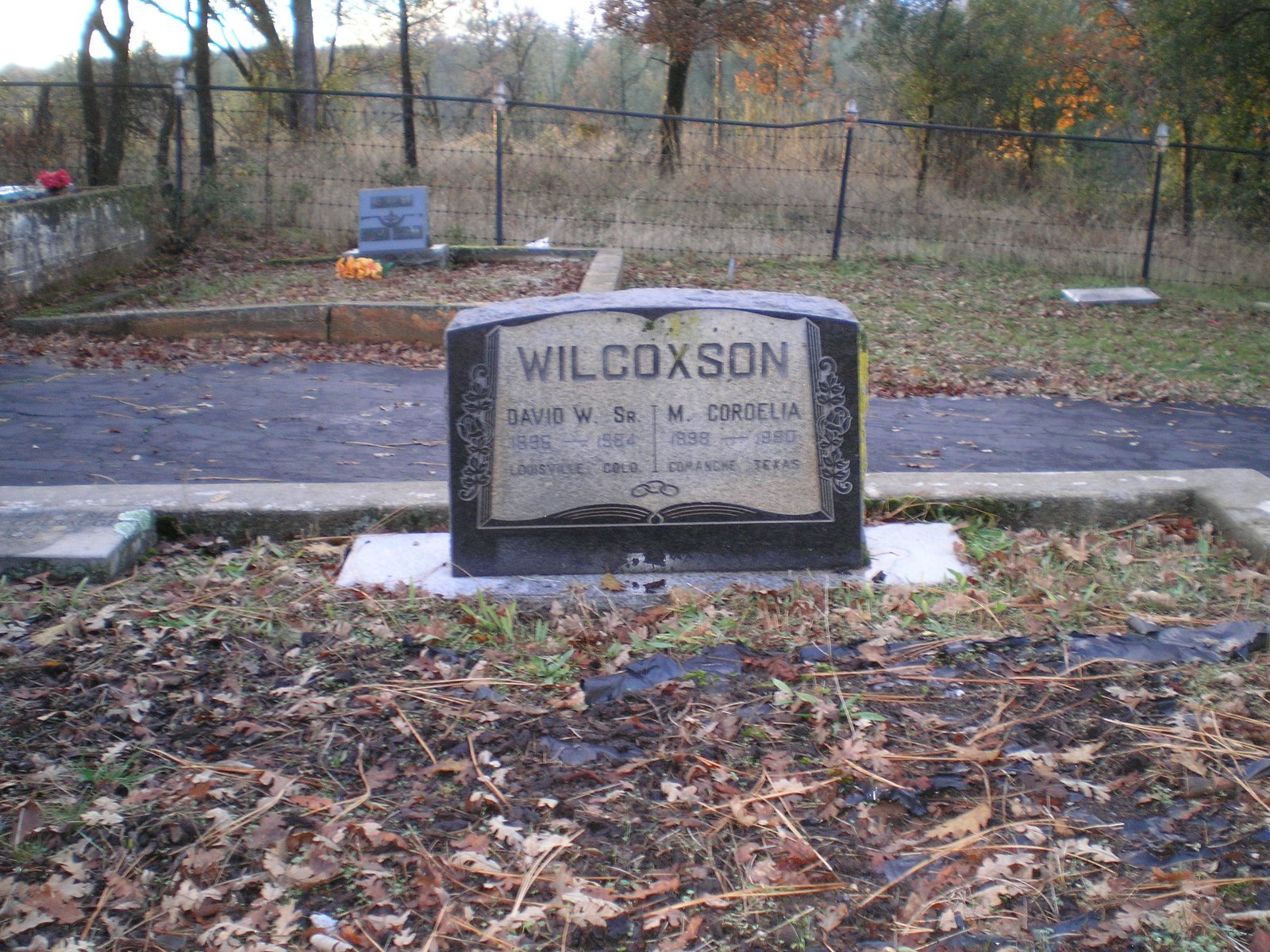
Tuolumne's Carter Cemetery [Established 1854]


    Here's the headstone for my grandparents, David W. Wilcoxson and Mary Cordelia Shackelford Wilcoxson. (Obviously I'll be back this summer to remove the black plastic along with any plants and weeds which sprout next spring.)


    The second Carter Cemetery photo shows the two additional gravestones in the Wilcoxson family plot. On the left is David W. Wilcoxson, Jr's and on the right is that of Cordelia's mother, Martha Elizabeth "Lizzie" Farley Schackelford Colbaugh [that's a mouthful!].


    As I was leaving yesterday I noticed a barber pole within one plot. That could have been for only one person: Johnny the Barber; but I decided to return this morning to take a photo of his plot. But this morning the gate to the cemetery was closed with a "Fresh Oil" sign on it. (Had noticed some new new asphault, but didn't realize how new it was.) In any case, I had to back down the hill using my side-view mirrors -- something I try to avoid.
--
    Johan "Johnny" Whittorf cut my hair many times when we five Lemmon kids spent most of the summers between 1948 and c1954 with our grandparents. Johnny had no relatives, and when he died he left a bigger estate than one might expect. Over the years he was a barber he invested in stocks. And by the time of his death in 1958 those stocks had risen in value. If memory serves, he willed the bulk of his estate to Summerville Elementary School -- though it's possible that Summerville High School also benefited from his version of The American Dream.

Obituary - Adolph Antinetti, Feb. 10, 1906 - Jan. 1, 2004
Longtime Tuolumne resident Adolph Antinetti died Thursday at a Sonora hospital. He was 97.

He was born in Angels Camp and came to Tuolumne City when he was 2 years old. His parents were Charles and Jenni Antinetti.

He served as the timber foreman of the Lightener Gold Mine in downtown Angels Camp. After traveling to Tuolumne City by the Sierra Railroad's Angels branch, they purchased and operated the Alpino boarding house, which was home to many West Side Lumber Company mill workers. Later, his parents moved to Sonora and ran the well-known Europa restaurant on Washington Street.

He attended Summerville Elementary School and Summerville High School. As a youth, he ran three trap lines south and east of town in the North Fork of the Tuolumne River Canyon. He and a close friend, "Chivy" Van Opstal, skinned their catch before going to class at the grammar school. At age 14, he worked summers in the West Side box factory and, at age 16, went to work in the woods at Hull Creek running a steam saw. At age 17, he owned and operated the Pastime Pool Hall on the corner of Chestnut and Main streets in Tuolumne. He sold candy, tobacco and sporting goods and ran card games. It was a popular establishment in those days, his family said.

On Aug. 11, 1928, he married Erna Rosasco, the daughter of Henry and Aurelia (Sivori) Rosasco, in Reno, Nev. They had two sons, Norman and Allan, who became high school teachers and coaches.

His family said he was a hard worker and pursued many interests. He worked with Fred Leighton building check dams in the Emigrant Basin. He ran a herd of cattle with Henry Rosasco. He worked for the Tuolumne County Road Department. He was a blacksmith and shoveled mine rock in the Soulsby Belle Gold Mine. During the Great Depression in 1933, he left home for seven months to take a seven-day-a-week road construction job in Sequoia National Park.

He was a Tuolumne City volunteer firefighter and was serving on the Tuolumne Fire Department Board of Directors when the first fire engine was purchased. He and a good friend, Bill Archer, acquired the plans for the Tuolumne Fireman's Theater, where he often operated the projectors.

In later years, he ran the gas shovel for West Side Lumber Company, building railroad grades at camps 43 and 44, around Woods Mountain and across Cherry Valley to Wilson Meadow. Many of these railroad grades are the present-day Forest Service roads in the area of Cherry Lake. In the 1940s, he left the woods and became part owner of the Shell gas station on Carter Street in Tuolumne. His partner was Bruce Nelson, and they ran a successful business for 24 years, his family said.

He retired in 1969 and remained active. He was a founding member of the Tuolumne Rod and Gun Club, a 41-year member of the Sonora Elks Lodge, a parishioner of St. Joseph's Catholic Church and belonged to Figli d' Italia. He loved riding his trail bike around Tuolumne and in the mountains, where he continued to fish and hunt, his family said. He rode trail bikes until he was 87 and drove his cars until he was 96.

In the early 1990s, he was co-grand marshal of the Tuolumne Jubilee Parade with his good friend, Al Bonales, with whom he cut firewood until they were well into their 90s.

He is survived by two sons and daughters-in-law, Allan and Mary Antinetti of Tuolumne and Norman and Pam Antinetti of Oakdale; grandchildren and spouses, Mark and Joanie Antinetti and Linda Antinetti Cazares, and her husband, Roberto, all of Tuolumne, Amy Antinetti of Turlock and David and Rachelle Antinetti of Oakdale; and five great-grandchildren.

A rosary is scheduled for 6 tonight at Heuton Memorial Chapel. A funeral service is scheduled for 10 a.m. tomorrow at St. Joseph's Catholic Church in Tuolumne.

Heuton Memorial Chapel is handling arrangements.
[From the 5 Jan 2004 Sonora Union Democrat]

--
F 10 Dec Route: Sonora - Groveland

Thursday, December 9, 2010

Sonora's Uptown Theater

Sonora (Tuolumne County) Fairgrounds

    Have spent slightly over a day at the Sonora Library searching through microfilm of the Sonora Union Democrat and an associated paper, the Tuolumne Independent, for articles, profiles, and ads about or from the Sonora Uptown Theater and the Tuolumne Fireman's Theater.

    A reference librarian directed me to a local history written by a woman who grew up in Jamestown and who has written local histories about both Jamestown and Sonora. Here's what Doris Fletcher-Mills wrote in her Sonora: Then and Now (c1997) about the Uptown Theater.

Uptown Theatre

    Although Sonora was first exposed to motion pictures in 1903, with films for the most part being shown in the Turn Venetian Hall, the first permanent motion picture theatre was established early in 1908 by Emery Girard and W.J. and F.J. Brenner, who formed the New York Amusement Company and rented a store on the west side of Washington Street, later to become Curnow's Appliance Store, where the films were shown on a white bed sheet hanging from the ceiling. In 1908, the New York Amusement Company was acquired by Julius Baer and Harry Cain. In July 1909, the company was sold to the Restano Brothers. Cain was retained as manager.

    In 1917, the Restanos decided to build a new theatre on South Washington Street on the site now occupied by Bank of America. Because the cost exceeded their expectations, the Restanos were forced to lease both the old theatre uptown and their uncompleted new theatre to June Knowles. Knowles formed a partnership with Eric J. Segerstrom and a few months later they sub-leased the theatre to Alfred George (A.G.) Clapp, who managed it until the mid-1920s, when the Restano Brothers again took over and installed Rick's son, Odillo, as manager.

    During Clapp's management, he had maintained a lease on the uptown site, which was then occupied by Cecil Mathews as a top shop. The Restanos let the lease go and Arthur D. Duchow open the Star Theatre (later to become known as the Uptown Theater) on December 1, 1927, in the building which he owned. The first film shown was "The Big Parade," a silent movie.

    "Uncle Tom's Cabin" and "The Great Train Robbery" were two of the most noteworthy films shown in the early days of the theatre.

    In the early days of the movies, a once a week event for most young people, [the most avidly-awaited shorts were] the serials (referred to now as the cliff-hangers). "The Adventures of Peal White," Laurel and Hardy, and the Keystone Cops were very popular. The "good guys" could be easily recognized because they wore white hats while the "bad guys" wore black ones.

    In the 1930s, Arthur Duchow played movies from the Star Theatre in various communities such as the old Moose Hall in Groveland. His successor, Norwood S. Tronsilin, continued the practice.

    "The remodeling of the Star Theatre makes it one of the nicest small town theatres in the state," according to an article on Nov. 13, 1936 in The Union Democrat. Not only is it beautiful and modern but moves toward being the safest building in Tuolumne County. The added room and screen size will meet with everyone's approval."

    Vernon S. McDonald, who was hired in 1921 as assistant janitor by Clapp while he was manager of the Sonora Theatre, became friends with the projectionist, Tom Long, who taught him how to operate the [projection] machines. When Long left, Vernon was given the job at a salary of $2.75 per night. As he was too small to set the upper reel on its spindle, he got his older brother, Earl, to assist him and the two ran the projectors unil the theatre was taken over by the Restanos.

    Vernon and Earl were then employed as projectionists by Duchow at the Star Theatre where Vernon supplemented his income by running the linotype machine at Duchow's Tuolumne Independent newspaper plant. Earl became a telegrapher at the Sonora Western Union office.

    Vernon's career as a projectionist covered both the silent movie days and the introduction of disc or record sound, in which the projectionist had to synchronize the sound with the action. He and his brother, Earl, soon learned to master the technique of briefly spinning the record a little faster at the expense of a few garbled words until the sound matched the lip movements whenever it became necessary.

    The disc or record sound system was soon replaced with the sound track on the edge of the film and the problem of synchronization was solved. There was still the problem of an occasional break in the film which then had to be spliced exactly right so that the synchronization was maintained.

[Much of the above courtesy of CHISPA]

    During the "Great Depression,"dishes and other enticements" were offered at the Uptown Theatre to bring customers in. It was a long, narrow building with an aisle down the center and a balcony where smoking was permitted.

    Coincidentally, the movie, "The Towering Inferno" was being advertised on the theatre marquee at the time of a minor fire in the projection room of the theatre.

    The Uptown Theatre was taken over by the Harvey Amusement Company which employed Robert Patton as manager. The theatre ran unhder this ownership for a number of years until Twin Cinema I and II Theatres open at the Sonora Plaza Shopping Center. Patton was hired as the first manager of the new theatres in late October 1976.

[From Doris Fletcher-Mills' Sonora: Then and Now, c1997, pp. 22-24]

Th 9 Dec Route: Sonora - Tuolumne - Riverside Guard Station Site

Wednesday, December 8, 2010

Photo Gallery1

Sonora (Tuolumne County) Fairgrounds


This is the first photo I took at the western end of Eight Mile Road and H&H [formerly Helen & Herman's] Marina, now owned by Houseboats.Com. It shows the Venice Island Ferry, a cable ferry, returning to the the island to pick up an auto waiting to be ferried to the Stockton side of the waterway. Note in the left center that the sun had recently set behind Mount Diablo and a few high thin clouds.
[Click once or twice to see bigger images.] Mount Diablo domination of the skyline to the west brought back memories of similar views on housboating trips of years past.

The second shot is from the dock at the back end of the cafe where we often gassed up or landed if there were other boats already docked in front of the cafe. Of course, when newbies were at the controls they sometimes misjudged the closeness of the dock, perhaps spilling a cup of coffee or two in the cafe. I didn't notice a fish-cleaning station to the right when I walked down to the dock from where I parked my rig on the levee.

The third shot is of the picnic area between front of the cafe and the store.


And the fourth and final shot shows some of the larger houseboats moored at the docks to the left of the store.


Woodward Reservoir County Park is located in the rolling hills to the west of Oakdale [Stanislaus] County Road J14/26 Mile Road and is the most senior-friendly RV park/campground I've encountered so far. Seniors get a full overnight hookup for $10. Rates listed by Tom Stienstra in his 2010 West Coast Camping were $15-23 per night.


Just as I/we had driven past the Woodward turn-off without investigating, I have also driven past the turn-off to Knights Ferry many times without driving down to what is called the longest covered bridge west of the Mississippi.


Here's a close-up. Obviously the original boards have been replaced several times since the bridge was originally built. But the reason for covering a bridge was to increase its life by shielding it from the elements. [Don't believe there's a covered bridge at Knights Landing further north in the Sierra foothills, but the two locations are sometimes confused.]

Took this shot of two large birds in the top of a tree near the covered bridge using the zoom so that I could see what color their beaks. The white or yellow confirms that they were buzzards or vultures -- which one invariably sees when driving from Sonora to Oakdale.

When I asked a young fellow at Burger King if there were any RV campgrounds on SR108 other than at Sugar Pine he said that Sonora Fairgrounds had an RV Park. Apparently the Mother Lode Fair Association is trying to derive some additional income from the vacant fairgrounds when it's not fair season. Cost was $20 for a partial hookup (electricity); if I understand correctly, it costs $25 to connect to water, which is at each side. But the additional $5 covers use of the dump station.

Monday, December 6, 2010

The House Which John & Nadine Built

Sutter Creek, CA.


During the three days I spent with cousin Nadine Colberg Mottoros and her husband John Mottoros I was impressed with their rather large house. While the photos I took Sunday after sundown are a bit dark, one can get a somewhat better view by clicking on them twice. [Hope to learn whether Google's Picasa, which is one of the sources blog-newbies must use to post photos to a Blogspot blog, can lighten photos such as those in this post; most graphics programs I've used on a desktop computer have that capability -- but not Microsoft's dinosaur program Paint.]

The house is built on two levels since it sits on a hillside next to a small creek; it has two outside stairs at its north and south ends as well as an inside stairs from the kitchen/dining-family room down to the living room.
....
Nadine is an outstanding cook. I particularly liked the salmon she prepared Saturday evening. And the next day John bought four freshly-cooked dungeoness crabs which we cracked, picked, and devoured for lunch Sunday. John does a considerable amount of cooking for the Native Sons of the Golden West, which Nadine calls "the Boys Club." He often enters the local chili-cookoffs, and has had a fair amount of success.

But the real character of the house is enhanced by its contents: "John's Toys," as he calls them. He has numerous nickelodeans, player pianos, and other electro-mechanical devices for which he sells music rolls. And, except for the player pianos, most of the devices have such things as drums, cymbols, tambourines, and pipes meant to simulate string and wind instruments. You might call the nickelodeans a "Band in a Box." They were used in taverns, saloons, etc. to entertain customes -- espcially those who had nickels to deposit in the slots.

One of John's other interesting collections is a set of videodiscs which contain many movie shorts produced for black audiences by Roy Mack. [I believe I've seen Mack's name on some piano sheet music.] The first short we watched was "Born to Tap," starring a young Sammy Davis Jr. and Ethel Waters. Others featured bands led by Eubie Blake and his song-writing partner Noble Sissle. Since I had only seen Eubie after Johnny Carson had him as a guest several times on the "Tonight Show" when Eubie was in his 90s, it was susrprising to see him with a bushy black moustache. But when he took off the chef's cap which was part of theme for the short, it was clear that his baldness did not begin during his old age.


The Creekside Cabin
If you have a chance to stay in Nadine & John's Creekside Cabin, which doubles as a guest house and a short-term rental, you'll not be disappointed. As one who stayed in motels from 4 Oct to 18 Nov, I believe the CC is better than any motel where I stayed -- even including those which were built in the last 3 or 4 years.

Be Prepared!
The Boy Scout motto came to the forefront of my memory during yesterday's drive from Sutter Creek. I had intended to go to the Stockton Library and do some genealogy lookups. But shortly after I found a parking place adjacent to a park (across Oak St from the library) in the Civic Center, two young Latinas who had parked near my rig and walked to the library returned to their car. As they began to back out of the diagonal parking, I knocked on the left window and asked if the library was open. "No," they replied in unison, "it's closed!"

So my lunch in the camper while parked on El Dorado St cost me an extra 50 cnts; parking is reasonable (especially when compared with rates near the State Capitol in Sacramento) at two-bits per hour. (Not sure if there's free public parking near the library.)

One side-benefit of the trip to the Stockton Library was that I passed an Arco gas station which was selling unleaded gas for $3.03, 6 cnts cheaper than the lowest I saw in the drive from Sutter Creek to downtown Stockton. It's at the corner of Harding Way and Center Street. [N.B. El Dorado St, the street on which the Chavez Library is located, is one-way North whereas Center St is one-way South.]

--
I-5 was just a short distance down Center Street; I took it north to Eight Mile Road to find the Stockton/Lodi RV Park c5 miles east of I-5. Never found it or any evidence as to where it might have been.

I then drove to the end of Eight Mile Road to the west at the Venice Island Ferry, which is located next to the former Helen & Herman's Marina; my ex-fishing buddy, Gordon Athearn, and I as well as others made numerous houseboating/fishing trips in the 80s & 90s from that marina, which is now owned by Houseboats.Com and is called H&H Marina. Took several photos of the docks, ferry, store, and a few houseboats -- again just after the sun had set behind Mount Diablo. Plan to post them shortly.


Not sure if the last 2-5 miles of Eight Mile Road are any rougher than they were years ago, but the stiff spings in my Ford F-250 made me slow down to slightly under the posted speed of 25 mph. Once back on I-5 I drove south, thinking I'd take SR120 to Manteca. However, I saw a sign on I-5 pointing to French Camp on SR4. While I had seen signs to French Camp for most of my life when my father or I drove to/from Tuolumne County, where my mother was raised, I had never been there. And after arriving on SR120 near Oakdale, I'm not sure I've been through French Camp even now; I suspect I was busy watching the road and didn't notice a sign.

The Woodward Reservoir RV Campground/Park has very reasonable prices for seniors -- only $10 for a full hookup. Couldn't find the self-registration station or forms, but I'll both pay and ask about those when I depart before noon (which is the usual check-out time for most CGs).


Today's Route: Sutter Crk - Pardee Resv - Comanche Resv - Stockton
Later Revision: Stockton - French Camp - Oakdale - Woodward Reservoir
Tuesday's Route: Oakdale - Jamestown - Sonora

Saturday, December 4, 2010

Murphy's Law in Action

Sutter Creek, CA.

As I told my cousin, Nadine Colberg Mottoros, who lives here in Sutter Creek with her husband John, the drive from Orland to Yuba City, Auburn, Placerville, and Sutter Creek was interesting and challenging. I ignored the Mapquest directions to use I-80 and US-50 to reach Placerville and got to see a bona fide mountain road, complete with turns marked with signs to "Slow to 15" -- during the afternoon commute home.
....
And State Route [SR] 49, know as the "Gold Country Highway or Road, did pass through Colma, the spot where John Marshall discovered traces of gold in a Sutter saw mill race in 1848. Here's more info on the Marshall Gold Discovery State Historical Park.

When I got to Placerville I had to find a free WiFi to request directions from Placerville to Sutter Creek since mine had to be read backwards. It appears that most of the newer Safeway Stores have WiFi. Got a new route to my cousin's place in Sutter Creek and headed south on SR49. When I got to the outskirts of Sutter Creek I thought my problems were over.

Not so! Sutter Creek was jammed with parked cars and people standing on or strolling the sidewalks for their annual Christmas party. And to make matters worse, I wasn't driving a VW Beetle but rather a large Ford F-250 with a good-sized truck camper. And, as John Mottoros pointed out, the streets were designed for wagons -- not autos and larger pickups.

But the biggest problem was narrow streets with cars and trucks parked on both sides, reducing the 2 lanes to just barely 1 lane. In fact, on one narrow back-street a truck equally as large as mine had parked next to a telephone pole or something else and protruded further into the roadway than any other vehicles. I inched past him with my side-view mirror just clearing the top of his. However, my problems were not yet over, for the road ahead said "Dead End."

I finally got to a spot near a drop down to someone's small parking lot ahead and decided to to turn the camper-laden pickup around in a spot just right for turning a VW beetle around. While I did push some dead limbs which had been pruned off of some trees on the uphill side of the road, I was able, with a lot of inching back and forth, to turn around. Made it past the bottleneck formed by the large blue pickup and, after one more drag up and down Main Street where I had hoped to catch a policeman or fireman within earshot, I headed out of town.

Stopped at a convenience store on the northern end of Sutter Creek, but a phone call to Nadine's number got a Disconnected beep and message. Then went to a Day's End Motel and started to use the WiFi hotspot near the Check-In desk when the woman managing the registration desk came downstairs. After she looked in a map without success for Orinda Street and Allen Ranch Road, she found a phone number in the phone book and dialed it for me.

Nadine answered and agreed with John's suggestion that she would drive down and lead me back to their place -- for which I was thankful. [Amen!]
--
Today's Lessons: 1)Murphy's Law - if anything can go wrong -- it will. And 2)have a backup such as a correct phone number even if the directions seem correct. (Both my cousin Nadine and the deskwomnan at the Day's Inn stated that Mapquest occasionally makes mistakes; for instance, there is no such street as Orinda in Sutter Creek to the best of their knowledges.)

Here are couple of links which might be of interest: brief Sutter Creek History and, if you have nickelodian piano, my cousin John's piano roll site, Johnny's Music Rolls.

Washed my bod yesterday before hitting the hay. Will wash my laundry tomorrow.
....
Not sure when I'll leave for an RV campground near Stockton; it depends in part upon the weather and weather forecast.

Friday, December 3, 2010

RV Parks & Repairs + An Obituary

Old Orchard RV Park, Orland, CA

The couple managing the Sacramento River RV Park at 6596 Riverland Drive have done a good job in renovating an RV park which had some problems when they took over its management. (It's located on a frontage road to I-5 about 5 miles south of Redding.)

Now the park is well-maintained with some of the less-desirable elements having been evicted. There are a considerable number of trees, many of which are natural old-growth trees rather than out-of-place palm trees imported by a landscaping firm, many plots of grass, and most important of all, clean restrooms with showers.

Since I'm a newbie at RV-ing, I especialy want to thank Bob, the husband of the woman who handles the "bean-counting" portion of the park management, for helping me solve my power problems. My 30-amp cable had likely been repaired by a previous owner, but he trimmed the heavy cable casing too far back from the socket. Bob, who had previously worked in marine electronics, quickly removed the floppy socket, cut off the overly-long 3 wires, stipped the heavy cable jacket off, stripped the wires, and reconnected the socket. [Incidentally, when I mentioned that I and my ex-fishing buddy had made house-boats trips from Helen & Herman'a Marina on 8-Mile Rd north of Stockton he said that he and his wife almost took the job of managing that marina.]
--
Now the socket doesn't look like it may be the cause of electrical problems such as a short or an open circuit. And when he finished the repair he used what I need to add to my Load List, a VOM (Volt Ohm Meter).
--
When we got back to my rig there was still no power inside after connecting it up. Bob made a quick check of circuit breakers and found that they were all off. Once on, I had "shore power."
--
If one still lacks power at an RV park after connecting to a sockets in the junction box at a site, there are several things one should double-check.

  • Is the circuit breaker in the junction box on?
  • Is the socket connected to your camper or RV firmly seated?
  • Are the circuit breakers in your control panel on?
If the circuit beakers trip as soon as you turn them on, you have something drawing a great deal of current. Leave the circuit breakers off and seek knowledgeable help.

RV Repairs

One place where you'll find knowledgeable help is at RV Service Centers. Since I had used the one in Santa Cruz to make repairs before hitting the road, I looked up the RV Service Center of Redding, aka Redding RV Center on-line while at the Redding Library.

I told Mark, the manager of the RV Service Center of Redding, that I had no power from my house battery; it had been out since I stopped for lunch at Weot two days previously. And since it only operated for 2.5 hours on one light and the radio the first night I used it in Castroville before the low-voltage alarm on the LP gas detector sounded (meaning the house battery voltage has dropped to <= 8.5 volts), I told him I thought I might need a new house battery.

He had one of his technicians check out my house battery, which is under one of the seats of the dinette; turns out the in-line fuse at one of the battery's terminals was blown.
....
While Mark could have easily sold me a new battery, the technician replaced the fuse, checked the battery under load, and told me it didn't act like a battery which was about to fail; he also confirmed that there was sufficient water in each cell.
....
Though I can't yet conclude that all RV Service Centers are totally reputable, the two I've used so far in both Santa Cruz and Redding are.
--
While the Old Orchard RV Park just to the west of Orland and I-5 at 4490 Country Road HH does not have WiFi, one can use the Orland Library, which is open every day except Sunday, to do some searching, check e-mail, or post one's blog. (The wife of the fellow who checked in me showed me an AT&T router, which should provide those in or near the office WiFi.)
....
The rates vary from $15 to $24; I paid the former and I suspect the owner of the large 1991 Class A RV towing a vintage 1971 VW likely paid the latter.
....
I discovered this RV Park in the "Sacremento & Gold County" section of Tom Stienstra's West Coast Camping, published in 2010. It covers RV parks as well as US Forest Service, Bureau of Land Management, Corps of Engineers, PG&E, state, county, and city camp sites. Of course, some sites have no hookups, but may be near places or things you wish to visit. And that's why one needs a well-charged house battery

An Obituary

Once I check my e-mail using the Orland Library's WiFi, will include today's route below.
....
Orland - Colusa - Yuba City - Grass Valley - Auburn - Placerville - Sutter Creek.

Thursday, December 2, 2010

The Greening of 135 Van Ness in Santa Cruz

Sacramento RV Park near Redding, CA.

While I had intended to include a couple of RV links in this post along with a link to a blog done by one of the new owners of our former home at 135 Van Ness Avenue in Santa Cruz, I've just read her entire blog and believe it deserves a separate post.

The Craftsman style house in which we lived from November 1954 to October 2010 was built by a furniture dealer named Frank Chapman in 1922. A 1923 article in the Santa Cruz Sentinel states that as a co-owner and manager of a furniture at the NW corner of Pacific Ave and Cathcart Street he had increased the store's business by 50%, attracting customers from as far as San Francisco to the north and Hollywood to the south.

He also became active in the Chamber of Commerce and built a home on a lot on Van Ness Avenue, no doubt having some say in the selection of wood used for the dining room buffet and framing the doors and windows. Sadly, less then 6 months after the Sentinel article had appeared he was dead at age 56, if memory serves.

The next owner, Arthur D. Wirt, who was a former petroleum engineer for Standard Oil in Kern County, lived at 135 Van Ness from 1926 to 1946 -- and likely planted the two apples trees in the backyard,

After Arthur Wirt's death in 1946 former real estate agent Fred Garrison bought the house and made some changes. He had the brown siding covered with a fake brick; and he used the left-over faux-brick for the walls of a shed he added to east side of the garage. And he added a kitchenette and another bathroom to the bedroom in the SW corner of the house. By walling off the door into that bedroom, he had a 3-room rental. (Incidentally, there was a gas jet which could be used for a small one-burner stove and there was a Kelvinator refrigerator.)

One of his renters during WWII was noted SCHS math teacher Alpheus Green, who may have been directed to the rental by another SCHS math teacher, Harlan Smith.

When Fred Garrison died in 1953 his widow Hattie lived there for nearly a year before selling the house to my father in Nov 1954. Some of our family members lived there longer than others; for instance, my two sisters, Jane and Eloise both got married and moved out. And later so did David and then Warren. I maintained 135 Van Ness as my address of record while working for the US Forest Service and serving in the army, once I was discharged I returned to 135 Van Ness.
--
However, the record-holder for living at the house which Frank built was my late mother, who lived there 55 years. Though I continued living there until the new owners took possession, I still didn't live there 55 years because of army service and 9 months teaching at Bishop Union High School.

But now the new owners, Chie Kawahara and Kurt Hurley will direct the evolution of 135 Van Ness. And you can not only follow that evolution but see some additional photos not provided by our real estate broker on Chie's blog, which is titled Midori Haus. (Not sure what "Midori" means in Japanese, but "House" is the English cognate for the German word "Haus.")

If you haven't been following Chie's blog, I suggest you start at the bottom with the first post and then move up to the more recent posts.
--
I look forward to the next chapter in the evolution of the house Frank built.

Thursday's Route: Sacramento RV Park Resort - Chico - Orland

Wednesday, December 1, 2010

Redding, CA.

Am currently at the Redding Library, a relatively-new two story building in the city's Civic Center, which in turn is just to the south of South City Park. Finally got one problem with the camper solved late yesterday afternoon.

When I stopped for lunch at Weot on my way from Ft Bragg to Eureka/Arcata I turned on the light over the kitchen sink & sideboard. Nada! Since I later learned that all of the circuit breakers had been tripped, my guess is that there was a voltage spike which not only tripped all of the breakers but blew the fuse on the charging circuit for the house battery, which is underneath one of the dinette seats.

Thought I might have to buy a new house battery since it had been low the first night I used it at Jim's Tripp's estate near Castroville on F 19 Nov and again when I was staying with Steve & Arlene in Ft Bragg. Of course, at the latter place I had turned on the light in the bathroom while downtown shopping and then neglected to turn it off.

Since both Arlene & Steve are younger than I, they could hear the low-voltage alarm on the LP-gas detector, which sounds when the house battery drops to <= 8.5 volts, when they fetched some firewood from the front porch. However, I couldn't hear that alarm until I got to within 10 ft of the camper.(Guess I inherited the ears of Bob Sr, Loyal Sr, and Dave Wilcoxson Sr.)


The young fellow at the RV Service Center of Redding tested the battery under load and said it didn't act like one that was failing -- it just needed to be charged up. The battery is charged by the truck's alternator while I'm driving or when I'm connected up to 110 volts ac; but apparently in the latter case, it's a trickle-charge, which doesn't restore it to full power for a long time.

After the RV Service Center closed last night I returned to the Redding Library to look up an obituary for Clinton Earl "Doc" Fehliman, who not only taught at Santa Cruz High School for 30+ years but also headed the SCHS Alumni Association for an even greater number of years. He died here in Redding while living with a nephew. (Will post that obit to this blog shortly.)

Spent the night at the Sacramento River RV Resort in a large pull-through site with both 30 & 50 amp electrical hookups. Hwr, the 30 amp socket was damaged and I finally had to resort of my flashlights to fix yet another peanut-butter & jam sandwich on sourdough bread for dinner -- plus some other things. As I told the owner this morning when I tried to get my billing changed to a tent site, they need to fix the 30amp socket; but I doubt that they will since the large site is designed for Class A RVs (the ones which often look like and are as big as a bus) which generally connect to a 50amp socket.

In walking around the rig this morning this morning after compromising with the owner by paying for a back-in site rather than a pull-through site ($4-5 less), I discovered that the left rear tie-down was missing and the eye-bolt to which it was connected now looks like a hook. It could have happened last night while I was trying to find my way onto I-5 south and went through a dip (which was signed well in advance -- in fact, too far in advance since I was just starting to speed up when I hit it) with a large jolt. Didn't hear anything metallic falling shortly thereafter; so it's possible that it had already fallen off previously.

Object Lesson: Check rig daily in the morning.

When I leave Redding will head for either Orland & Black Buttes Reservoir to its west or Chico.

Tuesday, November 30, 2010

Weaverville and Monterey Photos

Redding, CA

Here's a photo I took this morning in Weaverville at the home of cousin Doug Colberg. This is in the kitchen next to his small wood-burning stove; his wife Janet Ales "Tess" Colberg is standing next to him just before she went to work at the Trinity County Courthouse.


Here's the view from the front door of my motel room at the 49er Gold Country Inn one Main Street in Weaverville yesterday morning. As you can see there's still some snow on the ground from the front which went through on Saturday as well as the storms during the previous week.
....
Both Doug and Tess say it's the best motel in town even though it's not the newest; they stayed there when they moved from Clearlake to Weaverville.


Monterey. The image to the right was forwarded to me by my sister Jane Lemmon DiGirolamo; it was taken at her sister-in-law Tina DiGirolamo England's home.
....
Here's Jane's caption: Thanksgiving at Tina's. Back row [L-R]: Blaise, Marco (6), Michelle, Sara (22), Lori, Greg, Nick (almost 20) [sporting a sling after injuring his shoulder in a morning's football game] Front row: Sara (12) Adam (20) Tyler (16) & Madison (10).

--
Am currently at the Redding Library, the HQ of the Shasta County Library System. It's a rather new 2-story building at 1100 Parkview just south of South City Park.
....
Once I post this I'll look for a local obituary on C.E. "Doc" Fehilman, who died here at age 95 while visiting a nephew during a trip back to his hometown in Nebraska; he was buried next to his wife in a Santa Cruz Cemetery.


Posted by Picasa

Monday, November 29, 2010

Fort Bragg Photos


My hosts from Wed 25 Nov to Sun 28 Nov were cousin Arlene Lemmon Colombi and husband Steve Colombi. They are pictured at the right along with their daughter Kristene. The dog on the right is Kristene's and is named Sissy. The light-colored dog on the left is Steve's mother's dog Polly. And barely visible nearest to the stove is the real live-wire: Cleetus.


Eleanor Lemmon Dahl Holberg, who will be 96 next March, is pictured with her new watch-dog whose feet rarely stop moving. Believe her name is CiCi -- though a relative will likely correct that name as well as its spelling.

[Click any photo once or twice to enlarge.]


Standing near to the front of my rig holding onto the jack is Loyal A. Lemmon Jr, also known as "Jasper" or "Junior." He will be 90 on 21 Apr 2011. He was named after his father because he was born on the same day of the year as Loyal Sr.

Posted by Picasa

Mendocino Coast Surf South of Rockport

 
Posted by Picasa