Wednesday, May 29, 2013

Great Sand Dunes National Park, Colorado

Great Sand Dunes National Park, Craig, Colorado

Moffat County Library, Craig Colorado


    Much as Lewis & Clark had explored the northern portion of the Louisiana Purchase, Lieutenant Zebulon Pike was given the job of exploring the southern portion. [Click once to enlarge; press ESC to return here.]


    The access road to Great Sand Dunes Natl Park is off of US160 near the base of Mt Blanca, a 14,435' peak which the Navajos claim as a boundary of their original territory in Colorado.


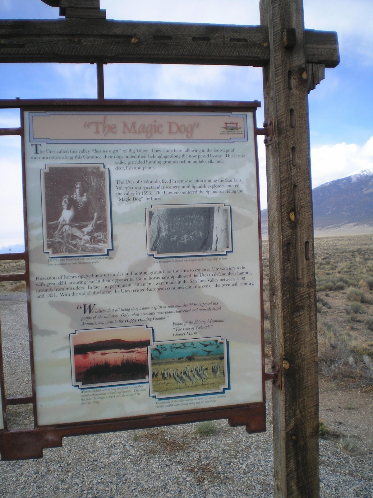
    Once the Ute Indians acquired horses, which they initially called "Magic Dogs," they were able to keep virtually all intruders out of the San Luis Valley from 1598 to 1851.


    A first view of the tallest sand dunes in the United States as well as the Colorado Rockies; one of the snow-capped peaks may be the one named for Lt Zebulon Pike. There are four fourteeners and four thirteeners in the massif, or connected series of peaks. Another in addition to Blanca Peak is Crestone Peak (14,294').


    A plaque notes that the sand dunes are visible from a great distance -- even if they are only a tan blur.


    A closer view of the sand dunes -- this time from the lowest road in the park service campground. Since there are quite a few things for children to do, this park attracts many visitors who have families. [This is one national park campground where it might be prudent to pay a bit extra to reserve a site.]


    As the evening shadows lengthened, I took another shot of the upper end of the dunes from the Pinyon Flats campground.


    Panning left....


    Another view with better light on the dunes, which contain some insects found nowhere else on earth. Since the sand is 150 degrees Fahrenheit in the summer, forget the Flip-Flops -- bring thick-soles, closed-toe shoes and walk the dunes early in the morning or in the evening.


    These clouds don't mean anything -- right?? Wrongo, Snow-shower breath!! The next morning the light scattered rain became a heavy wet snow just as I packed up. I skipped the 20-min film at the Visitor Center and headed for US160. The snow on the top of my camper didn't really start to melt til after I arrived on that highway and headed for the Fort Garland Post Office.


Links:
Return to Top of Page

W 5 Jun Actual Route: Rawlins, WY, Truck Stop bd - Rawlins P.O. - Rawlins Lib - Colo Hwy 13 bd

Th 6 Jun Actual Route: Colo Hwy 13 bd - Craig, CO, Lib - Craig Walmart

F 7 Jun Actual Route: Craig Walmart - Craig, CO, Lib - Marybell Lib - Dinosaur Lib - CO64 bd

Sa 8 Jun Actual Route: CO64 bd - Dinosaur - Jensen, UT, Dinosaur Natl Mon - Green River NPS CG

Su 9 Jun Actual Route: Green River NPS CG - Josie Morris Cabin - Jensen Utah Welcome Ctr - Valera - Roosevelt - Unitah Crk - Valera Walmart

M 10 Jun Actual Route: Valera, UT, W/M - Flaming Gorge Natl Rec Area - Mann's USFS CG

T 11 Jun Actual Route: Mann's USFS CG - Manila - Green River, WY, Lib - Rock Springs Walmart

W 12 Jun Actual Route: Rock Springs W/M - Rock Sprs Lib - Farson - South Pass bd

Th 13 Jun Actual Route: South Pass bd Lander USFS Ranger Sta - Sinks Cyn USFS CG

F 14 Jun Route: Sinks Cyn CG - Lander Lib - Ft Washakie - Arapahoe - Riverton Walmart


Finding Campgrounds:

N.B. I receive nothing from Trailer Life, Woodalls, or FreeCampsites.net for including links to their free campground lookups.

Sunday, May 26, 2013

Walsenburg to Fort Garland, Colorado

Walsenburg to Fort Garland, Colorado

Rawlins Library, Wyoming


    Spanish Peaks, which is also the name of the Walsenburg, Colorado, Library.


    A closer look at the rounded Spanish peaks close to the turnoff to LaVeta.


    [Click once to enlarge; press ESC to return here.]
    The Ute Indians called the mountains Huajatolla, which means the "breasts of the earth."


    LaVeta Pass is no longer on US160, but the west side of the mountains provided the first good-sized trees I had seen since the Cimarron Canyon in New Mexico.


    Believe the snow-capped mountains in the distance may be the Sangre de Cristo Mountains, which extend south from Colorado into New Mexico.


    Sierra Blanca (elev:14,351') north of US160 between Fort Garland and Alamosa; the access road to the Great Sand Dunes National Park is along the western flank of this peak in what is know as the San Luis Valley.


Links:
Return to Top of Page

F 24 May Actual Route: Lafayette W/M - Louisville Museum - Louisville Lib - Frederick - Platteville - Greeley W/M

W 29 May Actual Route: Harmony Rd W/M - CO Visitor Ctr - Council Tree Br Lib - Harmony Rd W/M

Th 30 May Actual Route: Harmony Rd W/M - Council Tree Br Lib - Cheyenne, WY, Main Lib - Cheyenne W/M - Chugwater - Wheatland - Jcn WY34 & US30/287 bd

F 31 May Actual Route: Jcn WY34 & US30/287 bd - Laramie W/M - Laramie Lib - Rawlins McDonalds - Truck Stop bd

Sa 1 Jun Actual Route: Rawlins Truck Stop bd - Rawlins P.O. - Rawlins Lib Pk Lot - RV World CG

Su 2 Jun Actual Route: RV World CG - Rawlins Lib Pk Lot - Flying J - Rawlins Truck Stop bd

M 3 Jun Actual Route: Rawlins Truck Stop bd - Rawlins P.O. - Rawlins Lib - Rawlins Truck Stop bd

T 4 Jun Actual Route: Rawlins Truck Stop bd - Rawlins P.O. - Rawlins Lib - Rawlins Truck Stop bd

W 5 Jun Actual Route: Rawlins, WY, Truck Stop bd - Rawlins P.O. - Rawlins Lib - Colo Hwy 13 bd

Th 6 Jun Route: Colo Hwy 13 bd - Craig, CO, Lib - Craig Walmart


Finding Campgrounds:

N.B. I receive nothing from Trailer Life, Woodalls, or FreeCampsites.net for including links to their free campground lookups.

Thursday, May 23, 2013

Bent's Old Fort, Colorado

Bent's Old Fort, Colorado

Rawlins Library, Wyoming


    When I arrived at Trinidad a snow storm was predicted for the next day. Checking my atlas I noticed that La Junta to the east was almost exactly 2000 ft. lower; so I drove to La Junta, where there was some rain but no snow.
    Bent's Old Fort is a replica of a key fort along the Santa Fe Trail.


    One sees many plaques donated by the DAR (Daughters of the American Revolutions) but very few by the Daughters of the 1810 Rvolution (or War with Britain). [Click once to enlarge; press ESC to return here.]


    A plaque/map of additional sites to the east along the Santa Fe Trail both in Colorado and western Kansas.


    An aerial view of Bent's Old Fort, which is clearly made of adobe.


    Points of interest as well as difficulty to the west of Bent's Old Fort near La Junta.


    Because this National Monument closes two gates at 4:30 p.m., I had to park outside the monument and traverse the roads via Shank's Mare. [N.B. There is a golf cart for those unable to walk the quarter of a mile from the restrooms to the Fort.] (The rocks outline the cemetery.)


    There may be a pot-bellied stove inside the Fort given the pile of firewood both in an above plaque as well as this photo.


    Since the indians also traded at the fort, the cannon is "just in case...."


    Though he's in the shade, a male peacock likely spread his tail for the nearby female rather than to warn me to "back off."


    The fort also had a corral as well as pens for cattle. [Examined one big bull carefully, but he was more interested in feeding than in running me out "of his territory."


    At each corner of the fort there is a circular tower from which defenders inside the fort can fire upon any miscreants attempting to scale the walls.


    [Click once to enlarge; press ESC to return here.]
    Among those who had visited or lived at Bent's Old Fort were John C. Fremont, Susan Magoffin, who kept a diary, the Bent's family slave, Charlotte, Kit Carson, Yellow Wolf, Jim Beckwourth, after whom a trans-Sierra pass is named, and Lt. J.W. Abert, whose maps, diaries, and sketches facilitated the reconstruction of Bent's Old Fort in 1976.


Links:
Return to Top of Page

F 24 May Actual Route: Lafayette W/M - Louisville Museum - Louisville Lib - Frederick - Platteville - Greeley W/M

Su 26 May Actual Route: Greeley W/M - Greeley Br Lib - Ft Morgan W/M

M 27 May Actual Route: Ft Morgan W/M - Ft Morgan Lib

T 28 May Actual Route: Ft Morgan W/M - Ft Morgan Lib - New Raymer - Ault Lib - Fort Collins - Harmony Rd W/M

W 29 May Actual Route: Harmony Rd W/M - CO Visitor Ctr - Council Tree Br Lib - Harmony Rd W/M

Th 30 May Actual Route: Harmony Rd W/M - Council Tree Br Lib - Cheyenne, WY, Main Lib - Cheyenne W/M - Chugwater - Wheatland - Jcn WY34 & US30/287 bd

F 31 May Actual Route: Jcn WY34 & US30/287 bd - Laramie W/M - Laramie Lib - Rawlins McDonalds - Truck Stop bd

Sa 1 Jun Actual Route: Rawlins Truck Stop bd - Rawlins P.O. - Rawlins Lib Pk Lot - RV World CG

Su 2 Jun Actual Route: RV World CG - Rawlins Lib Pk Lot - Flying J - Rawlins Truck Stop bd

M 3 Jun Route: Rawlins Truck Stop bd - Rawlins P.O. - Rawlins Lib - Rawlins Truck Stop bd

T 4 Jun Route: Rawlins Truck Stop bd - Rawlins P.O. - Rawlins Lib - Rawlins Truck Stop bd


Finding Campgrounds:

N.B. I receive nothing from Trailer Life, Woodalls, or FreeCampsites.net for including links to their free campground lookups.

Sunday, May 19, 2013

Folsom, New Mexico to Trinidad, Colorado

Folsom, New Mexico to Trinidad, Colorado

RV World Campground*, Rawlins, Wyoming


    Looking north from the Capulin to Folsom road over the Clayton-Raton Volcanic area. This photo was taken from just north of Capulin Volcano Nation Monument (see below).


    Panning right....


    An Unsung Hero: Sally Rooke. [Click once to enlarge; press ESC to return here.]
    No, Sally was not like the "dingy" Central Operator Ernestine portrayed by Lily Tomlin for years. She gave her all to prevent others from suffering the fate which ended her life at approximately age 65. And the $433.40 contributed in 1908 dollars is worth several times that in today's inflated dollars.


Links:

     * RV World Campground -- a well-run, well-maintained RV Park where the owners will treat you right. Here's a link to their web site
Return to Top of Page

F 24 May Actual Route: Lafayette W/M - Louisville Museum - Louisville Lib - Frederick - Platteville - Greeley W/M

Su 26 May Actual Route: Greeley W/M - Greeley Br Lib - Ft Morgan W/M

M 27 May Actual Route: Ft Morgan W/M - Ft Morgan Lib

T 28 May Actual Route: Ft Morgan W/M - Ft Morgan Lib - New Raymer - Ault Lib - Fort Collins - Harmony Rd W/M

W 29 May Actual Route: Harmony Rd W/M - CO Visitor Ctr - Council Tree Br Lib - Harmony Rd W/M

Th 30 May Actual Route: Harmony Rd W/M - Council Tree Br Lib - Cheyenne, WY, Main Lib - Cheyenne W/M - Chugwater - Wheatland - Jcn WY34 & US30/287 bd

F 31 May Actual Route: Jcn WY34 & US30/287 bd - Laramie W/M - Laramie Lib - Rawlins McDonalds - Truck Stop bd

Sa 1 Jun Actual Route: Rawlins Truck Stop bd - Rawlins P.O. - Rawlins Lib Pk Lot - RV World CG

Su 2 Jun Actual Route: RV World CG - Rawlins Lib Pk Lot - Flying J - Rawlins Truck Stop bd

M 3 Jun Route: Rawlins Truck Stop bd - Rawlins P.O. - Rawlins Lib - Rawlins Truck Stop bd


Finding Campgrounds:

N.B. I receive nothing from Trailer Life, Woodalls, or FreeCampsites.net for including links to their free campground lookups.

Tuesday, May 14, 2013

Clayton Lake State Park, NM, to Black Mesa, OK

Clayton Lake State Park, NM, to Black Mesa, OK

Louisville Library, Colorado

    The road from Clayton Lake State Park, NM370, was mainly dirt & gravel - for 35 miles. And NM456 was also unpaved until I got closer to the Oilahoma border. These were the first houses I saw after leaving Clayton Lake SP except for a few isolated farm houses.


    There was a fairly new NMDOT Maintenance Facility at the bottom of the hill from which I took both the above shot as well as this one; however, it appears to have been closed for at least 2 years. Not sure if the NDOT plows the road down to the upper end of the Cimarron River (Bed) or not. The nearest big town in Oklahoma is Boise City, a considerable distance away.

    "Black Mesa is a basalt-capped plateau formed by the flow of an ancient volcano. It is about 45 miles long and extends from Colorado, where it is know as the 'Mesa de Maya,' through New Mexico to just inside the northwest tip of the Oklahoma panhandle," according to "Black Mesa Nature Preserve" brochure I picked up at the Capulin Volcano Natl Monument. This shot shows Black Mesa in New Mexico.


    Not too far from the Oklahoma border NM356 is paved; the route number in Oklahoma is 325.


    This shot, taken on a Sunday well after services ended, was of Black Mesa from the Kenton Methodist Curch and presumably includes the highest point in the state of Oklahoma, 4973', which is marked by a native granite monument.


    McNees Crossing on the Cimarron, named for young John McNees, who was killed by Comanches at the spot where the Cimarron Cutoff of the Santa Fe crossed the Cimarron River. An even more experienced traveler died on his first attempt to use the Cimarron Cutoff. His name: Jeddediah Smith. [See links below.]


    Rabbit Ear Mountain as seen by travelers on the Santa Fe Trail. See the post immediately below for a view from US64/US87 on the opposite side.


Links:
Return to Top of Page

Th 23 May Actual Route: Lafayette W/M - Boulder Carnegie Local History Museum - Louisville Lib - Lafayette W/M

F 24 May Actual Route: Lafayette W/M - Louisville Museum - Louisville Lib - Frederick - Platteville - Greeley W/M

Su 26 May Actual Route: Greeley W/M - Greeley Br Lib - Ft Morgan W/M

M 27 May Actual Route: Ft Morgan W/M - Ft Morgan Lib

T 28 May Actual Route: Ft Morgan W/M - Ft Morgan Lib - New Raymer - Ault Lib - Fort Collins - Harmony Rd W/M

W 29 May Actual Route: Harmony Rd W/M - CO Visitor Ctr - Council Tree Br Lib - Harmony Rd W/M

Th 30 May Actual Route: Harmony Rd W/M - Council Tree Br Lib - Cheyenne, WY, Main Lib - Cheyenne W/M - Chugwater - Wheatland - Jcn WY34 & US30/287 bd

F 31 May Actual Route: Jcn WY34 & US30/287 bd - Laramie W/M - Laramie Lib - Rawlins McDonalds - Truck Stop bd

Sa 1 Jun Actual Route: Rawlins Truck Stop bd - Rawlins P.O. - Rawlins Lib Pk Lot - RV World CG

Su 2 Jun Route: RV World CG - Rawlins Lib Pk Lot


Finding Campgrounds:

N.B. I receive nothing from Trailer Life, Woodalls, or FreeCampsites.net for including links to their free campground lookups.

Thursday, May 9, 2013

Capulin Volcano National Monument to Clayton, New Mexico

Capulin Volcano National Monument to Clayton Lake State Park, NM

Goodland Library, Kansas


    The Capulin Volcano (actually a Cinder-Cone) as seen from the NNW on the road to Folsom.
    Capulin, pronounced cah-poo-LEEN, is Spanish for Chokeberry; its elevation is 8182 ft.


    [Click once to enlarge; press ESC to return here.] Information on the Raton-Clayton Volcanic Field.


    A view to the SouthWest from the road to the top of the cinder cone.


    Panning to the right....


    Though I'm not certain, the cinder cone in this photo may be Baby Capulin, elev: 6890'.


    Click once to enlarge; press ESC to return here. As with many National Monuments, one person was largely responsible for the land's preservation; in this case it was Homer Farr, who engineered and built the spiral road to the top of the cinder cone.


    A somewhat-better view to the SW from the rim of the crater.


    While it looks like a sandy desert to the south, that's not the case.


    The bottom of the crater. Had the next eruption occurred here, there would have been no cinder cone. Rather the next eruption, largely of cinders or scoria (frothy chunkds of volcanic rock) occurred at the base of the pre-existing cinder cone.


    The far rim of the cinder cone's crater.


    A notable landmark along the Santa Fe Trail: Rabbit Ear Mountain.


    The first of two New Mexico Historical markers just to the west of Clayton on US56. [Click once to enlarge; press ESC to return here.]


    As it turns out, Clayton was a given name rather than a surname. [See Links below.]


Links:
Return to Top of Page

M 20 May Actual Route: US36 bd - Bennett, CO - Aurora May Br Lib - Green Valley Ranch Blvd bd

T 21 May Actual Route: Green Valley Ranch Blvd bd - Downtown Denver - Broomfield - Louisville Lib

W 22 May Actual Route: Louisville Lib - Boulder Carnegie Local History Museum - Louisville Lib - Lafayette W/M

Th 23 May Actual Route: Lafayette W/M - Boulder Carnegie Local History Museum - Louisville Lib - Lafayette W/M

F 24 May Actual Route: Lafayette W/M - Louisville Museum - Louisville Lib - Frederick - Platteville - Greeley W/M

Sa 25 May Actual Route: Greeley W/M - Greeley, CO, Br Lib - Greeley W/M

Su 26 May Actual Route: Greeley W/M - Greeley Br Lib - Ft Morgan W/M

M 27 May Actual Route: Ft Morgan W/M - Ft Morgan Lib

T 28 May Actual Route: Ft Morgan W/M - Ft Morgan Lib - New Raymer - Ault Lib - Fort Collins - Harmony Rd W/M

W 28 May Actual Route: Harmony Rd W/M - CO Visitor Ctr - Council Tree Br Lib - Harmony Rd W/M


Finding Campgrounds:

N.B. I receive nothing from Trailer Life, Woodalls, or FreeCampsites.net for including links to their free campground lookups.