Wednesday, October 26, 2011

Yosemite: Tioga Road

Sonora, CA

    On 19 October, after a stop at the Lee Vining Library to check my e-mail, I drove up CA120 toward the Tioga entrance to Yosemite N.P.
    With my hat shading the camera lens from the sun I took the shot to the right of Tioga Peak (elev:11,526'); the road contours to the left side of the peak before entering the park.


    A look down into the canyon of Lee Vining Creek.


    Panning to the left I looked for a USFS campground, which a Lee Vining librarian felt were still open; but I cudn't spot any RVs, campers, etc.


    Further up the road I noticed a couple of building along Lee Vining at the head of the canyon; given the steepness of the canyon, wouldn't want to spend the winter there since avalanches likely occur.


    A view to the left of Tioga Peak; note that the snow from early October had not yet melted.


    Ellery Lake -- where I saw more rises on the lake than I've seen elsewhere in total.


    Mt Dana (13,057'), which sits on the crest of the Sierra Nevada, above Dana Meadows.


   Plaque on the silver-mining town of Bennettville, which saw a boom and a bust starting in 1874.


   Probably the Dana Fork of the Tuolumne River in Dana Meadows.


   Mt Gibbs (12.764').


   Upper (eastern) end of Tuolumne Meadows.


   Panning left for more of Tuolumne Meadows.


   On the left, Ragged Peak; in the center, Mount Conness (12,590') behind a closer White Mountain, and Gaylor Peak on the right.


   Panning left, the western end of Tuolumne Meadows.


   Like a beached whale, Lembert Dome lies on Tuolumne Meadows.


   A plaque explaining the various zones found as elevation increases: from Foothill to Alpine.


   The "nose" of Lembert Dome. [Actually, I was just using this shot to fill up my camera's memory so that I could download the photos to my laptop.]


   Upper (NE) end of Tenaya Lake. The only other lake in the Sierras I recall with such a sandy shoreline is Dorothy Lake, also in Yosemite, near Bond Pass.


   Looking toward the outlet of Tenaya Lake as the sun sets.


   [Click 1 or 2 times to zoom in.] Yosemite's most notable feature or landmark as seen from Olmsted Point through clouds billowing up from Yosemite Valley: Half Dome!


   A plaque explaining the importance of the Frederick Olmsteds, Senior and Junior, to the development of Yosemite N.P.


   A plaque at Olmsted Point explaining the geological forces which have created Yosemite as well as the glaciers which sculpted the granite.


   Mount Hoffman (10,850') on the left and Tuolumne Peak (10,845') on the right.


   Parking for the night at the Yosemite Creek Parking Lot. NOT! The young woman at the Tioga Pass Entrance Kiosk was direct and to the point when I asked if anyone would bug me if I parked overnight at Yosemite Creek. She said I'd get a ticket. When I groused that I had parked there in early November during the 20+ years I backpacked to/from Ten Lakes, she replied, "Things have changed." How true.
   There is now no overnight parking in Yosmite after 14 Oct.


   The Yosemite Creek valley above Tioga Road just before dusk.
--


Links:

T 25 Oct Actual Route: East of Long Barn - Sonora - Tuolumne - East of Long Barn

W 26 Oct Actual Route: East of Long Barn - Sonora - East of Long Barn

Th 27 Oct Actual Route: East of Long Barn - Sonora - East of Long Barn

F 28 Oct Actual Route: East of Long Barn - Sonora - East of Long Barn

Sa 29 Oct Actual Route: East of Long Barn - Sonora - 3Links CG

Su 30 Oct Actual Route: 3 Links CG - Tuolumne - Riverside Picnic Area

M 31 Oct Actual Route: Riverside - Tuolumne - Sonora - Groveland R.S. - Pines CG

T 1 Nov Actual Route: Pines CG - Big Oak Flat Entrance (Yosemite) - Glacier Pt - Wawona CG

W 2 Nov Actual Route: Wawona CG - Oakhurst - Lupine-Cedar Bluff CG (Bass Lake)

Th 3 Nov Route: Cedar Bluff CG - Oakhurst - Coarsegold - Raymond - Eastman Lake CG

F 4 Nov Actual Route: Eastman Lake CG - Raymond - Mariposa Fairgrounds - Bagley Recreation Area (Lake McClure)

Sa 5 Nov Actual Route: Bagley CG - Coulterville - Greeley Hill - Anderson Valley - Pines CG (near Groveland R.S.)

Su 6 Nov Route: Pines CG - Wards Ferry [Bridge] - Tuolumne - Sonora - N.F. Tuolumne River
--

Finding Campgrounds:

N.B. I receive nothing from Trailer Life or Woodalls for including links to their free campground lookups.

Tuesday, October 25, 2011

Mono Lake

Sonora, CA


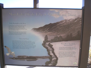
    A plaque on Mono Diggings taken on 19 October at the Vista Point just south of Conway Summit on US395 overlooking Mono Lake. [Click 1 or 2 times to zoom in.]


    Things to see and do in and around Mono Lake.


    "In the Rainshadow of the Sierra."


    The western portion of Mono Lake with the northern end of the snow-capped White Mountains in the distance. [Oh -- what fire?]


    Panning left one can see the largest island in Mono Lake: Paoha, where many birds used to nest until dropping water levels uncovered the land bridge to the northern shore; one Paoha was accessible, the varmits didn't waste any time in feasting on the bird eggs.


    The northeastern portion of Mono Lake, which, according to my June 1999 AAA map, had an elevation then of 6372'.


    At the picnic area near the tufa towers, a plaque explaining how the Piutes, in most cases, were forced to change their lives with the arrival of white men.


    "Strange Water, Strange Tufa."


    No -- I wasn't falling to my right when I took this photo, but there was a strong north wind.


    The largest concentration of tufa towers are on the south shore of the lake.
--


Links:

Sa 22 Actual Oct Route: 3Links CG - Sonora - Tuolumne - East of Long Barn

Su 23 Oct Actual Route: East of Long Barn - Mi-Wuk Village - Tuolumne - Sonora - East of Long Barn

M 24 Oct Actual Route: East of Long Barn - Tuolumne - East of Long Barn

T 25 Oct Actual Route: East of Long Barn - Sonora - Tuolumne - East of Long Barn

W 26 Oct Actual Route: East of Long Barn - Sonora - East of Long Barn

Th 27 Oct Route: East of Long Barn - Sonora - East of Long Barn
--

Finding Campgrounds:

N.B. I receive nothing from Trailer Life or Woodalls for including links to their free campground lookups.

Saturday, October 22, 2011

Lake Tahoe - Part II

Sonora, CA

    After spending the night at William Kent Campground just south of Tahoe City, I started the day with this photo from the W.Kent Vista Point looking NE; the trees at the left surround Lake Forest on Dollar Point while the mountains of Nevada are visible in the distance.


    Being too tight-fisted to pay for entrance to Sugar Pine Point Sate Park I continued south to D.L. Bliss State Park, where I was able to walk toward the somewhat steep shore and take the photo to the right. Most of the trees here are sugar pines because they lack the symmetry of ponderosa pines.


    One of the peaks along the eastern edge of Desolation Wilderness, which is located to the SW of Lake Tahoe.


    A look across the lake at Stateline, NV. [Click 1 or 2 times to enlarge.] You may be able to see the multi-story casino/hotels there.


    Since I was shooting these photos from Emerald Point you can make out part of Emerald Bay if you look closely.


    A look to the NW from Emerald Point; there has been considerably less development on the Nevada side of the lake, in part, because it is more mountainous. Since there was virtually no wind, no the wake where a boat had traveled previously.


    Am not sure of the name of the ski area on the Nevada side, but a schuss-boomer may well get a long run for his money.


    Emerald Bay. [Click once or twice to zoom in.] Note the fortress-like walls on the Fannette Island.


    Panning left one can see the mouth of Emerald Bay between Emerald and Eagle Points.


    A map of the Rubicon-Emerald Bay Area.


    An explanation of Lora Knight's Vikingsholm, which means Vikings Bay.


    An explanation of early-day touring at Lake Tahoe.


    From Inspiration Point, a view of a paddle-wheeler passing Fannette Island. If memory serves, one or more of the boats were originally from California's Sacramento-San Joaquin Delta. [Check links below and the next photo.]


    A plaque explaining the "rich and colorful past" of Emerald Bay.


    A plaque describing Mrs. Lora Knight's Vikingsholm. [Incidentally, the building on Fannette Island was apparently a teahouse.]


    A plaque explaining the completion of a road around Lake Tahoe. One result was the scuttling of the Tahoe, often call the "Queen of the Lake," in 1940. And, if you think the roads are rough now, check the photo included of the days when touring was a real adventure.
--
Links:

F 21 Oct Actual Route: East of Long Barn - Mi-Wuk Village - Sonora - 3Links CG

Sa 22 Actual Oct Route: 3Links CG - Sonora - Tuolumne - East of Long Barn

Su 23 Oct Actual Route: East of Long Barn - Mi-Wuk Village - Tuolumne - Sonora - East of Long Barn

M 24 Oct Actual Route: East of Long Barn - Tuolumne - East of Long Barn

T 25 Oct Route: East of Long Barn - Sonora - Tuolumne - East of Long Barn
--

Finding Campgrounds:

N.B. I receive nothing from Trailer Life or Woodalls for including links to their free campground lookups.