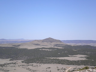
The Capulin Volcano (actually a Cinder-Cone) as seen from the NNW on the road to Folsom.
Capulin, pronounced cah-poo-LEEN, is Spanish for Chokeberry; its elevation is 8182 ft.

[Click once to enlarge; press ESC to return here.] Information on the Raton-Clayton Volcanic Field.

A view to the SouthWest from the road to the top of the cinder cone.

Though I'm not certain, the cinder cone in this photo may be Baby Capulin, elev: 6890'.

Click once to enlarge; press ESC to return here. As with many National Monuments, one person was largely responsible for the land's preservation; in this case it was Homer Farr, who engineered and built the spiral road to the top of the cinder cone.

A somewhat-better view to the SW from the rim of the crater.

While it looks like a sandy desert to the south, that's not the case.

The bottom of the crater. Had the next eruption occurred here, there would have been no cinder cone. Rather the next eruption, largely of cinders or scoria (frothy chunkds of volcanic rock) occurred at the base of the pre-existing cinder cone.

The far rim of the cinder cone's crater.

A notable landmark along the Santa Fe Trail: Rabbit Ear Mountain.

The first of two New Mexico Historical markers just to the west of Clayton on US56. [Click once to enlarge; press ESC to return here.]

As it turns out, Clayton was a given name rather than a surname. [See Links below.]
Links:
- National Park Service web pages on Capulin Volcano National Monument
- Wikipedia article Capulin Volcano National Monument
- Wikipedia article on Clayton, NM
Return to Top of Page
M 20 May Actual Route: US36 bd - Bennett, CO - Aurora May Br Lib - Green Valley Ranch Blvd bd
T 21 May Actual Route: Green Valley Ranch Blvd bd - Downtown Denver - Broomfield - Louisville Lib
W 22 May Actual Route: Louisville Lib - Boulder Carnegie Local History Museum - Louisville Lib - Lafayette W/M
Th 23 May Actual Route: Lafayette W/M - Boulder Carnegie Local History Museum - Louisville Lib - Lafayette W/M
F 24 May Actual Route: Lafayette W/M - Louisville Museum - Louisville Lib - Frederick - Platteville - Greeley W/M
Sa 25 May Actual Route: Greeley W/M - Greeley, CO, Br Lib - Greeley W/M
Su 26 May Actual Route: Greeley W/M - Greeley Br Lib - Ft Morgan W/M
M 27 May Actual Route: Ft Morgan W/M - Ft Morgan Lib
T 28 May Actual Route: Ft Morgan W/M - Ft Morgan Lib - New Raymer - Ault Lib - Fort Collins - Harmony Rd W/M
W 28 May Actual Route: Harmony Rd W/M - CO Visitor Ctr - Council Tree Br Lib - Harmony Rd W/M
Finding Campgrounds:
- RV Campgrounds from TrailerLifeDirectory.com
- Family Camping Directories from Woodalls.com
- Free campsites website
- Info on finding BLM Campgrounds


No comments:
Post a Comment