Monday, October 7, 2013

Mesa Verde National Park, Colorado

Mesa Verde National Park, Colorado

San Angelo, TX, Library


    Despite problems on both my previous trip to Mesa Verde Natl Park in 2012 [see links below] as well as this year, I don't consider this park haunted. [These photos were taken on 6 Sep 2013.]
    This is the most well-preserved cliff dwelling in the park: the Spruce Tree House.


    Though the sandstone blocks were the principal building material held together by a dirt & water mortar, there were wooden reinforcements as one can see at the left side of The Spruce Tree House.


    Almost all of the vertical lines in this shot are very regular. One can infer that they had an equivalent of twine to which they could tie a heavy rock to act as a plumb bob.


    The black on the overhanging cliff was from two sources: 1)wood-smoke & 2)seeping water.


    Not sure of the purpose of the protruding timbers just below the roofs, but that "architecture" is carried on today in many building in the Southwest.


    This circular underground, sometimes with a roof, chamber was a community multi-purpose room.


    Note in this closeup that many, if not most, of the openings are framed with wood.


    The "roof" above the roofs; that is, the overhanging cliff.


    As the Anasazi found that they could supplement things they gathered with crops they grew, they begain to build more permanent places to live. This plaque was on the site of a pithouse built in 575 AD. (The so-called "Classic Pueblo Period of the cliff-dwellers was from 1150 to 1300 AD.)
      The Antechamber


      Pithouse Likely Burned


Links:

Th 24 Oct Actual Route: Brownwood W/M - Comanche Court House - Hamilton - Waco W/M

F 25 Oct Actual Route: Waco W/M - Marlin - Centerville - Madisonville - Huntsville W/M

Sa 26 Oct Actual Route: Huntsville W/M - Point Blank - Onalaska - Livingston W/M

Su 27 Oct Actual Route: Livingston W/M - Livingston Lib - Escapees HQ & RV Pk - Livingston W/M

M 28 Oct Actual Route: Livingston W/M - Escapees HQ & RV Pk - Polk County Tax Assessor - Livingston Lib - Onalaska - Huntsville W/M

T 29 Oct Actual Route: Huntsville W/M - Navasota - Brenham - Giddings W/M

W 30 Oct Actual Route: Giddings W/M - Giddings Lib - Elgin - Austin McDs - Austin Br Lib - Austin Shopping Ctr

Th 31 Oct Actual Route: Austin Shopping Ctr - Austin FedEx Office - Lampasas W/M - San Saba - Brady W/M

F 1 Nov Actual Route: Brady W/M - Brady Lib - Eden P.O. - Eden Lib - San Angelo VA Clinic - Sherwood Way W/M

Sa 2 Nov Route: Sherwood Way W/M - Freudiger RV Services - San Angelo Lib - Sherwood Way W/M


Finding Campgrounds:

N.B. I receive nothing from Trailer Life, Woodalls, or FreeCampsites.net for including links to their free campground lookups.

Saturday, October 5, 2013

Black Canyon of the Gunnison National Park, Colorado

Black Canyon of the Gunnison National Park, Colorado

San Angelo, TX, Library

    When most canyons are formed they are V-shaped -- like the Feather River in California or parts of the Snake River along the Idaho/Washington border. But if they've undergone glaciation, they become U-shaped -- like the Merced River in Yosemite Valley. But's there's one river which is neither V- or U-shapped; the Black Canyon of the Gunnison River in Colorado is I-shaped! [These photos were taken on 15 Aug 2013.]


    You'll note that you cannot see the river in either of these first two photos. One reason is the deepness of the canyon (2772' at Warner Point). And the lack of sunlight is why it's known as the Black Canyon of the Gunnison.


    As the park brochure states, "in just 48 miles in Black Canyon the Gunnison River loses more elevation than the 1,500-mile Mississipi River from Minnesota to the Gulf of Mexico.


    The river drops an average of 96 feet/mile over the 14 miles inside the park.


    One of the few spots where the sunlight illuminates the river.


    Don't lean over too far when taking this photo.


    Wonder if Evel Knevel ever considered jumping this canyon?


    This section of the river looks so docile that one wonders if it's still the Gunnison.


    Doubt that many fishermen have fished these holes.


    Though I was shooting into the sun, here's a view of the Painted Wall, at 2300' it is apparently the highest cliff in Colorado.
    Met an Italian couple, Diego & Tiziana, though I believe they both have been living, perhaps on opposite coasts, in the U.S. for at least a couple of years. Since I'm Irish and my two sisters married three Italians, we talked for quite a while.


    A plaque which points out that if the Empire State building were placed on the bottom of the canyon, it would not reach half-way up the Painted Wall.


Links:

F 11 Oct Actual Route: Sherwood Way Walmart - San Angelo Lib - Sherwood Way Walmart

Sa 12 Oct Actual Route: Sherwood Way Walmart - San Angelo Lib - Sherwood Way Walmart

Su 13 Oct Actual Route: Sherwood Way Walmart - San Angelo Lib - Sherwood Way Walmart

M 14 Oct Actual Route: Sherwood Way W/M - San Angelo Lib - Wash Pot Laundromat - Sherwood Way W/M

T 15 Oct Actual Route: Sherwood Way W/M - San Angelo P.O. - San Angelo Lib - Sherwood Way W/M

W 16 Oct Actual Route: Sherwood Way W/M - San Angelo Lib - Sherwood Way W/M

Th 17 Oct Actual Route: Sherwood Way W/M - San Angelo Lib - Sherwood Way W/M

F 18 Oct Actual Route: Sherwood Way W/M - San Angelo VA Clinic - San Angelo Lib - Sherwood Way W/M

Sa 19 Oct Actual Route: Sherwood Way W/M - San Angelo Lib - Sherwood Way W/M

Su 20 Oct Actual Route: Sherwood Way W/M - SW Rd McD's - Sherwood Way W/M

M 21 Oct Route: Sherwood Way W/M - San Angelo Lib San Angelo State Park


Finding Campgrounds:

N.B. I receive nothing from Trailer Life, Woodalls, or FreeCampsites.net for including links to their free campground lookups.

Thursday, October 3, 2013

Glacier National Park - Part III

Glacier National Park, Montana - Part III

San Angelo Library, Texas


    On the NE side of Logan Pass headed for Lake St Mary. (Links to Part I & II below.) [All Glacier NP photos taken on 7 July.]


    Since the east side cooled down faster, clouds which had disippated earlier began reforming.


    More clouds forming.


    Panning left....


    A waterfall nestled in the trees.


    Like Lake McDonald, St Mary Lake is also quite large.


    The mountains at the upper end of St Mary Lake have "the typical Rockies look" even though they also had much glaciation as did the more volcanic Cascades or the Sierra Nevada near the west coast.


    Wind and water erosion much like what one sees in the U.S. Southwest.


    One of the many ferries or excursion boats cuts across a seemingly-calm St Mary Lake.


    The boat approaching its mooring place in the bay to the left looks rather small in comparison to St Mary Lake.


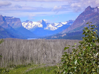
    No simple two-ocean divide for Triple Divide Peak; rather, its slopes drain into Hudson Bay, the Pacific Ocean and the Gulf of Mexico.


    Even after sundown the view is still spectacular.


    One careless cigarette or match....


    Looking back toward Glacier Natl Park from near St Mary the next morn.


    Panning right....


    The back side of the burn seen the previous evening.


    The upper end of St Mary Lake.


    The north-eastern end (or outlet) of St Mary Lake.


    Whatever (deer?) has been nibbling on the sunflower petals decided the seed pod in the center is not as tasty.


Links:
Return to Top of Page

<

Tuesday, October 1, 2013

A Lemmon Obituary: Richard Mark Lemmon

A Lemmon Obituary: Richard Mark Lemmon

San Angelo, TX, Library

--
Obituary
--
circaFriday 24 September 2012 Pendleton, OR, Pioneer Chapel Website
--
    Richard Mark Lemmon was born August 26, 1926 in Baker, Oregon to Warren Mac Lemmon and Vera Virginia Schlaefer.
     Dick attended schools in Baker and graduated from Baker High School in 1944. Basketball was his favorite sport. He played on a team in 1943 that won second place in the State Basketball Tournament. He enjoyed spending summers at his Grandfather Lemmon's cabin on Granite Boulder Creek.
    Dick joined the Naval Aviation Cadet program in March 1944-near the end of World War II. He was discharged October 1945 at the end of the war.
    In the fall of 1945 he went to work for the U.S. Forest Service and worked for them seasonally while attending Oregon State College where he obtained a degree in Forestry, graduating in 1950. He worked at various places for the Forest Service - Blue Mtn. Ranger Station, Seneca, Unity, Portland and Pendleton spanning a career of 33 years. He served as District Ranger in two different districts - Unity and Pendleton and the Regional Office in Portland. He thoroughly enjoyed working for the Forest Service in the outdoors.
    Dick married Mona Jean Mitchell, September 1949 in the Salt Lake Temple of The Church of Jesus Christ of Latter-Day Saints. Mona Jean passed away and he married Dona Marie Jeffords September 1976 in the Logan Temple of The Church of Jesus Christ of Latter-Day Saints. He was an active member of The Church of Jesus Christ of Latter-Day Saints serving in many capacities - Scout Master, Sunday School Teacher, High Counselor, Bishop, Temple Worker and Stake Patriarch. Dick and Dona served a mission in Nigeria. Dick loved serving the Lord and his fellowman.
    In his retirement years he enjoyed traveling to visit family, picking huckleberries and spending time at Diana's cabin, cutting wood and being in the mountains. Dick was preceded in death by his wife, Mona Jean, his parents, brothers Boyd and Jack and a son-in-law Steve Frazier.
    He is survived by his wife, Dona; sons, Andrew (Cathy), Scott (Kathy), Kevin, John (Melinda); daughters, Rhonda Gardner (Gil), Elaine Fresh (Stephen), Diana, Jolene Simpson (John); brother, John (Jeanette); 44 grandchildren, 44 great-grandchildren and many nieces and nephews.
    The family will greet friends at a viewing on Friday, September 28, 2012 from 7:00pm to 8:30pm at The Church of Jesus Christ of Latter-Day Saints, corner of 12th and Gilliam in Pendleton. Funeral services will be held Saturday, September 29, 2012 at 10:00am at the same location as the viewing.
    Memorial contributions may be made to the Humanitariam Program of The Church of Jesus Christ of Latter Day Saints, c/o Pendleton Pioneer Chapel, Folsom-Bishop, 131 SE Byers Ave., Pendleton, Oregon 97801. ....................................................................................................................
Source: http://www.pioneerchapel.com/obits/obituary.php?id=208498 ....................................................................................................................


Links:
Return to Top of Page

T 1 Oct Actual Route: Abilene Walmart - Mockingbird Ln Br Lib - Sweetwater McDs - Walmart

W 2 Oct Actual Route: Sweetwater Walmart - McDs - Big Spring VA Hosp - Howard County Lib - US87 bd

Th 3 Oct Actual Route: US87 bd - Sterling City, TX, - San Angelo Lib - 29th St Walmart

F 4 Oct Actual Route: 29th St Walmart - San Angelo VA Clinic - San Angelo Lib - Sherwood Way Walmart

Sa 5 Oct Actual Route: Sherwood Way Walmart - San Angelo Lib - Sherwood Way Walmart

Su 6 Oct Actual Route: Sherwood Way Walmart - Big Lots - Sherwood Way Walmart

M 7 Oct Actual Route: Sherwood Way Walmart - San Angelo Lib - Sherwood Way Walmart

T 8 Oct Actual Route: Sherwood Way Walmart - San Angelo Lib - Sherwood Way Walmart

W 9 Oct Actual Route: Sherwood Way Walmart - Jim Noland State Farm Office - San Angelo Lib - Sherwood Way Walmart

Th 10 Oct Actual Route: Sherwood Way Walmart - San Angelo Lib - Sherwood Way Walmart


Finding Campgrounds:

N.B. I receive nothing from Trailer Life, Woodalls, or FreeCampsites.net for including links to their free campground lookups.