Louisville Library, Colorado

The first of two large lakes along the Going-to-the-Sun Road just inside the west entrance to Glacier Natl Park at 3153 ft. Waterton Lakes National Park in Canada and Glacier Park in Montana have formed Waterton-Glacier International Peace Park since 1932.

[Click once to enlarge; press ESC to return here.] A plaque on the Robert fire, which started outside of the park on 23 Jul and spread into the park, burning until 8 Sep when nearly an inch of rain & snow finally ended its spread.

Another view toward the outlet of Lake McDonald, which is 11? miles long.

Yet another view toward the west end of the lake, where the Apgar Visitor/Transit Center is located.

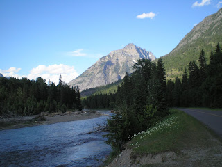
A look up the Lake McDonald inlet stream, McDonald Creek. Not sure whether the peak is Heavens Peak (8987') or Mt. Oberlin (8180').

Looking down McDonald Creek from where the previous photo was taken.

A view up McDonald Creek from McDonald Falls.

Perhaps this is Heavens Peak. But it was taken from in front of a restroom where I met a couple from Alberta, Dave & Lori, who were headed for their cabin on Swan Lake in Montana.

Perhaps this is Avalanche Creek. But one thing is certain -- that this was one of the last straight stretches of road, for the climb to Logan Pass was not far ahead.

Longfellow Peak? (8904') from "The Loop," where the "Going-to-the-Sun" stops following McDonald Creek and does a 180 to head for Logan Pass.

From the Loop at 4300' a shot of the Lewis Range, which includes many glaciers.

One of the more interesting plaques which explains why National Park Service Director Stephen Mather chose a more expensive but more picturesque route to Logan Pass. [Click once to enlarge; press ESC to return here.]
[More photos to follow in Part II once I get to the Gunnison, CO, Lib
Links:
- National Park Service web pages on Glacier National Park
- Wikipedia article on Glacier National Park
Return to Top of Page
F 9 Aug Actual Route: Craig W/M - Craig Lib - Craig P.O. - Craig W/M
Sa 10 Aug Actual Route: Craig W/M - Craig Lib - McDs - Meeker, CO - Rifle Colo Rest Area - Walmart
Su 11 Aug Actual Route: Walmart - Rifle Lib - Walmart
M 12 Aug Actual Route: Walmart - Parachute Br Lib - Grand Jcn Walmart
T 13 Aug Actual Route: Walmart - VA Med Ctr - Grand Jcn Lowe's - Colo Natl Monument CG
W 14 Aug Actual Route: Colo Natl Mon CG - Grand Jcn - Delta Lib - Montrose Walmart
Th 15 Aug Actual Route: Montrose Walmart - Black Canyon of the Gunnison Natl Pk
F 16 Aug Actual Route: Black Canyon of the Gunnison Natl Pk - Curecanti Natl Rec Area CG
Sa 17 Aug Actual Route: Curecanti NRA CG - Gunnison Lib - Crested Butte bd
Su 18 Aug Actual Route: Crested Butte bd - Carbondale - Glenwood Springs Walmart
M 18 Aug Route: Glenwood Springs W/M - Glenwood Sprs Lib - Carbondale Lib
Finding Campgrounds:
- RV Campgrounds from TrailerLifeDirectory.com
- Family Camping Directories from Woodalls.com
- Free campsites website
- Info on finding BLM Campgrounds

No comments:
Post a Comment