Showing posts with label Wheeler Peak. Show all posts

Sunday, March 30, 2014

Some State High Points

Some State High Points

Moab Library, UT Updated on 25 May 2014

    Many of you may be wondering why I haven't been posting any new photos. The reason is that my new laptop/notebook runs Windows 8.1, and my camera manufacturer, Olympus, has not updated their Master software to work with Microsoft's latest Operating System. [A cynic might conclude that Olympus wants those of us using their older cameras to shell out for newer cameras. Per the advice of a UCSC computer science grad I ordered a USB card reader which may allow me to move photos from my camera to my laptop -- and thence to this blog.]

    Another software firm, Google, whose Picasa program allowed me to upload photos from my Olympus camera to my laptop, also has not updated that program to work with Win8.

    One of my goals during my travels has been to take photos of the highest peaks in each state I visit; what follows are the High Points in most of the western states as well as Texas and the Rocky Mtn states north to the Canadian border. (I debated whether to list the High Points in alphabetical order or some sort of geographic sequence; the latter won out!)


    A view of Washington's Mt. Rainier (14,414') taken on 12 Jun 2012.
    Natl Park Service website.


    The highest peak in Oregon is Mt. Hood at 11,249'; I have no photo of it yet; see the 1st link below.


    California's Mt Whitney (14,494') as seen from Inyo County's Portagee Joe Campground. For more info see the 2d entry in the Links below; it has an excellent photo on a National Park Service page called "Climbing Mt. Whtiney."


    Nevada's Boundary Peak (13,147') as seen from US Hwy 6 not too far from Montgomery Pass.


    More info.


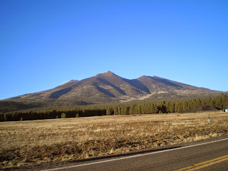
    Arizona's Humphrey's Peak (12,637') in the San Francisco Mtns just north of Flagstaff.
    See the 3d link below for more info.


    New Mexico's Wheeler Peak (13,159') to the north-east of Taos.

    More info.


    I drove around the Ashley Natl Forest hoping for a clear view of Utah's Kings Peak (13,534'), but there was never a clear shot until I was back on the nearest highway. See the 4th link below for a good photo.


    See 5th link below for a photo of Idaho's Borah Peak (12,662 or 12,668')


    See the 6th link below for a photo of Colorado's Mt Elbert (14,440')


    And Wyoming's Gannett Peak (13,809') is the 7th link below.


    Montana's Granite Peak (12,807') as seen from the Beartooth Highway.

    More info.


    Guadalupe Mtn (8,751'), TX, in Guadalupe Mtns Natl Park.


More info


    While reading my 2008 World Almanac I noted Mt Harney, the highest point in South Dakota and realized I had a photo of it taken after I visited Mt. Rushmore. See Link #8 below for more info.


[Return to the top of the page]
Links:
  1. Wikipedia article on Mt. Hood, OR
  2. Climbing Mt. Whitney
  3. Wikipedia article on Arizona's Humphrey's Peak
  4. Wikipedia article Utah's Kings Peak
  5. Wikipedia article on Idaho's Borah Peak
  6. Wikipedia article on Colorado's Mt Elbert
  7. Wikipedia article on Wyoming's Gannett Peak
  8. Wikipedia article on South Dakota's Harney Peak
  9. Wikipedia list of states by elevation

Routes:

Th 10 Apr Actual Route: Riverton W/M - Riverton P.O. - Payson - Nephi Lib - Ephraim W/M

F 11 Apr Actual Route: Ephraim W/M - McDs - Salina - Richfield Dollar Tree - Circleville - Panguitch Lib - UT143 bd

Sa 12 Apr Actual Route: UT143 bd - Panguitch Lib - Cedar Breaks Natl Mon - Kanab, UT - Vermilion Cliffs NM, AZ

Su 13 Apr Actual Route: Vermilion Cliffs NM - Marble Cyn - Grand Canyon NP - Flagstaff, AZ - Winslow bd

M 14 Apr Actual Route: Winslow bd - Holbrook Lib - Sanders, AZ - Gallup, NM, Walmart

T 15 Apr Actual Route: Gallup Walmart - Albuquerque - San Mateo Blvd & Zuni Rd W/M

W 16 Apr Actual Route: San Mateo & Zuni W/M - Erna Fergusson Br Lib - VA Hosp - San Mateo/Zuni W/M

Th 17 Apr Actual Route: San Mateo/Zuni W/M - VA Hosp - Erna Fergusson Br Lib - San Mateo/Zuni W/M

F 18 Apr Actual Route: San Mateo/Zuni W/M - San Pedro Br Lib - Dollar Tree - Tony Hillerman Br Lib - Wyoming Blvd W/M

Sa 19 Apr Route: Wyoming Blvd W/M - Hillerman Br Lib - Wyoming Blvd W/M


Finding Campgrounds:

N.B. I receive nothing from Trailer Life, Woodalls, or FreeCampsites.net for including links to their free campground lookups.

Wednesday, May 1, 2013

Santa Fe to Taos, New Mexoco

Santa Fe to Taos, New Mexico

Alamosa Public Library, Colorado


    Though US64, or its predecessor, used to leave the Rio Grande River, that now happens farther upstream than Velarde. [Click once to enlarge; press ESC to return here.]


    Not sure why, but in one spot where US64 leaves the Rio Grande, there was a hillside with a shrine and several crosses.


    There were several spots along the river where those who rode it downstream could take out their rafts, kayaks, etc.


    Looking downstream, here's one of those spots.


    Having seen a sign to a US Forest Service Visitor Center which I thought was called Grand Canyon of the Rio Grande, I stopped near a hilltop and took this shot. Believe the wide canyon is just above the bushes on the other side of the road.


    Panning to the right we see the mountains to the north of Taos, one of which is Wheeler Peak, the highest point in New Mexico at 13,000'+. Taos is just over the crest of the road.


    Panning right yet again, I at first thought Wheeler Peak was in this group of mountain-tops.


    Just over the crest of the hill I finally got a view of the Rio Grande Gorge. [Click once to enlarge; press ESC to return here.]


Links:
Return to Top of Page

Su 5 May Actual Route: Pueblo W/M - Pueblo Main Lib - Pueblo W/M

M 6 May Actual Route: Pueblo W/M - Lamb Br Lib - Walsenburg Lib - US160W bd

T 7 May Actual Route: US160W bd - Walsenburg Lib - LaVeta Lib - Fort Garland bd

W 8 May Actual Route: Fort Garland bd - Fort Garland/Blanca Lib - Great Sand Dunes NP - Pinyon Flats CG

Th 9 May Actual Route: Great Sand Dunes NP Pinyon Flats CG - Ft Garland/Blanca Lib - Ft Garland P.O. - Alamosa Lib - Alamosa W/M

F 10 May Actual Route: Alamosa W/M - Alamosa Lib - Alamosa W/M

Sa 11 May Actual Route: Alamosa W/M - Alamosa Lib - Poncho Sprs - Salida W/M

Su 12 May Actual Route: Salida W/M - Salida Lib - Coaldale - Royal Gorge - Canon City W/M

M 13 May Route: Canon City W/M - Canon City Lib - Canon City W/M


Finding Campgrounds:

N.B. I receive nothing from Trailer Life, Woodalls, or FreeCampsites.net for including links to their free campground lookups.

Saturday, March 12, 2011

Cathedral Gorge [NV] State Park to Ely

Ely, NV


    Here are three photos I took at at Cathedral Gorge State Park not too far from Panaca, NV. When I arrived I was only the 2d vehicle there, but a couple more vehicles pulled in after dark.


    The base color of the cliff is the same as Red Rock State Park on SR14 in CA north of Mojave, but the formations have less variety.


    With the sun setting in the west I took shot to the NE, East, and SE; there are apparently some caves in the cliff but I didn't attempt to explore them since I wanted to get on the road to Ely.


    The next 2 photos were taken just past a crest on US93 short of the small town of Pioche. [Wonder if any Italians ever lived there?]


    They capture the snow on the mountain ranges along the Utah/Nevada border.


    [Click 1 or 2 times to see the snow-capped mtns to the north.]


    Took this shot thinking it included some salt flats rather than the ice of a shallow, frozen lake; now I'm not certain which it is.


    One of the peaks within this range is Wheeler Peak, c13,065; while it not the highest peak in Nevada [Boundary Peak just north of the White Mtns on the western border of the state with California holds that distinction], if memory serves, it is one of the highest in the eastern part of the state.


    One last look up the road, for just a short distance ahead US Highways 6 & 50 joined US93 at Majors Junction -- and all three headed over a low range where the clouds had been thickening I was taking photos to the east. I cud see what appeared to be light rain as I started up the steady grade with my speed control set at 45mph to conserve gas.
--
    While there was some light rain, it wasn't steady; and when it turned to light snow, I thought about turning on the defroster, but I was at the c6750' summit by then & when the speed limit changed from 45 to 70, I assumed [correctly, as it turned out] that there would be fewer curves.
    While I ate a small burger and fries I tried to remember the name of the RV park I had marked in my Trailer Life Directory. Eventually found it as well as the Prospector Hotel/Motel/Casino/RV Park. After I left McDonald's I drove about 1.5 mi out of Ely on US93, following a new Class A with a toad. As the driver of that RV was checking in to the Valley View RV Park, he asked about WiFi. The 2 young kids working the desk said it was going to be out for a while. I piped up and said that since I had no cell phone, I'd have to go back to the Prospector, which one reviewer had praised for its WiFi.
    And the price was right: only $11.10 for a full hookup (I normally only need electricity) and not super, but good WiFi. (But I ain't as picky as some of those driving large RVs.) The Prospector Casino/RV Park might be dusty during the dryer seasons since it's a mix of dirt and gravel.

Links:

Sa 12 Mar Actual Route: Cathedral Gorge [NV] State Park - near Pioche - Ely

Su 13 Mar Route: Ely, NV

M 14 Mar Route: Ely, NV

T 15 Mar Route: Ely - Currant - Warm Springs - Tonopah, NV