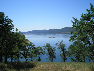
While I had intended to walk down to the lake to take a photo of New Melones Res, the raptor in the dead oak tree appeared to have a white head. Will ask before I exit tomorrow if there are bald eagles nesting here. Also, heard a single gobble shortly after I parked at the same site as yesterday, #121 in the Big Oak CG, part of the Glory Hole Campgrounds here; believe the campground host said yesterday that there were wild turkeys here.
One arm of the lake where houseboats are anchored.
A floating dock to the left of the houseboats in the above photo; a large boat chugs by a little further out in the lake.
Unfortunately, there are no sidewalks along the SR49 bridge -- just a sign warning you not to trespass on state property. So I shot through a break in the trees on the right side of the road while headed toward Sonora.
I walked across the road and was about to walk down a small bank to perhaps get a better view up the lake toward Parrott's Ferry, but spotted a plant with bright green, oily leaves; the clusters of 3 leaves identify it as poison oak.
Here's a look to the east up the inlet arm of the New Melones Lake; the lake covers 12,500 acres and has over 100 miles of shorline at an elevation of 1,085'.
When I got to the Sonora Library, I discovered that it was closed, which is similar to most, but not all, of the Calaveras County Libraries. After eating lunch in the nearly-empty parking lot I notice a very large (20-25' tall) donkey engine in the 49er Park next to the library. Note that the skids are beveled on the front (cable take-up) end. When fired up with wood, the steam power could easily pull donkey engine up a hill. However, given its rather large size, I suspect that it was used in a lumber yard rather than in the woods were overhead clearance might have been a problem.
The donkey engine was built by the Williamette Iron & Steel Works in Portland, Oregon. Forgot to look for a date, but most were built between c1885 and c1915, when gas-powered trucks and tracters were put into use.
My late father, Robert Lemmon Sr, was hired as a teacher, principal, & janitor at Shaw's Flat Elementary School in September 1940. As a 1- or 2-year old I remember being there when my dad taught the kids how to shoot .22s after school, placing the targets against the red clay bank. What I noticed for the time today is that the Shaw's Flat Cemetery is at the top of the bank.
With my hat shielding the camera's lens I took a photo of the east side of the school building. My guess is that there were some additions over the years: first on the left and then on the right. While the school is probably a K-6 school now, it covered grades 1-8 in the early 1940s. (Incidentally, my father was hired because some of the bigger boys had "run off" the previous female teacher; the fact that he was on the San Jose State Boxing team helped land the job.
When I visited the building during the summer of 1969 with an uncle's widow, there were no trees or concrete; they have been added since then.
The James G. Fair mentioned in the history of Shaw's Flat not only made money at Shaw's Flat but he was also one of the principal owners of the Comstock Silver Mine in or near Virginia City, Nevada. Further, he was the principal financier railroad from Alameda to Felton in the Santa Cruz Mountains. [Note correct middle initial for James Fair; see links below.]
And here's a photo of the bell used to call the miners to court hearings, meetings, etc.
Tuttletown, a short distance from Shaw's Flat, became home to a group of Mormons who were drafted into the U.S. Army and forced to march 2,000 miles from Council Bluff, Iowa, to San Diego to aid in the Bear Flag Revolt against Mexico. After their service they were prospecting for gold before John Marshall's discovery on 28 January 1848; my guess is that the Mexicans were aware of the presence of gold -- but not in the amounts which were later found.
--
Links:
- Wikipedia article on San Andreas, CA
- Wikipedia article James Graham Fair
- Biography of James G. Fair written in 1881 by Myron Angel
- History of South Coast Pacific Railroad
T 3 May Actual Route: New Melones Lake CG - Angeles Camp - San Andreas - New Hogan Lake CG
W 4 May Actual Route: New Hogan Lake CG - Valley Springs -New Hogan Lale CG
Th 5 May Actual Route: Valley Springs - Stockton Chavez Library - Lathrop Library - Dos Reis County Park
F 6 May Actual Route: Dos Reis County Park - Lathrop - Stockton - Dos Reis Pk
Sa 7 May Actual Route: Dos Reis Pk - Lathrop - Stockton - Clements - Lake Amador
Su 8 May Actual Route: Lake Amador - Jackson - Indian Grinding Rock State Park
M 9 May Route: Indian Grinding Rock State Park - Jackson


No comments:
Post a Comment