Corte del Rey RV Park, Huachuca City, AZ

After spending the night in the parking lot of the Green Valley, AZ, Walmart I headed south. Stopped at the Tumacacori Mission, which was founded a year earlier than San Xavier Mission near Tucson.
While I had not intended to go into Nogales, I skipped my Mapquest directions and followed the highway signs to AZ82, Patagonia Road or Patagonia San Rafael Rd. My route traced out a V rather than the U-shaped route Mapquest suggested.
Here's a first look at Patagonia Lake on Sonoita Creek from a crest in the road from AZ State Route 82.

The mountains to the west of the Santa Cruz River, a tributary of the Gila River; it flows north through Tucson and joins the Gila to the southwest of Phoenix. One may think that driving south on I-19 is downhill, but Tucson has an elevation of 2389' whereas Nogales is at 3865'.

A shot of Patagonia Lake from near the entrance gate and building.


Panning right one can see a marina where boat rentals are available; if memory serves, private watercrafts are banned. While it's barely visible throught a mesquite tree, a two-pontoon boat, powered by foot-pedals or a small outboard, is headed away from the marina.
I stopped on the way back to AZ82 on Patagonia Lake Road and took this photo to the south. The mountains you see in the distance are in northern Mexico.

A photo of the west side of the mountains which separate the Patagonia Lake/Sonoita area from the Huachuca City/Sierra Vista area. While there appears to be snow in some of the gullies near the top of the mountains, south and west slopes are likely free of snow by the beginning of March even though there is still snow on the east side of this range.

An Arizona Highway Department Landmark on Camp Crittenden, which was established in Aug 1871 to protect Babocomari, Sonoita, and the Santa Cruz vall[ies] against indians. It was abandonned in Jul 1873. Believe it or not I saw a sign just past Sonoita pointing to a winery, the first I've encountered in Arizona.
I'm not sure how many different routes there are from Santa Fe to Los Angeles, but in 1882 my great-grandfather, George Thomas Lemmon, followed one of them to the Pacific Coast.
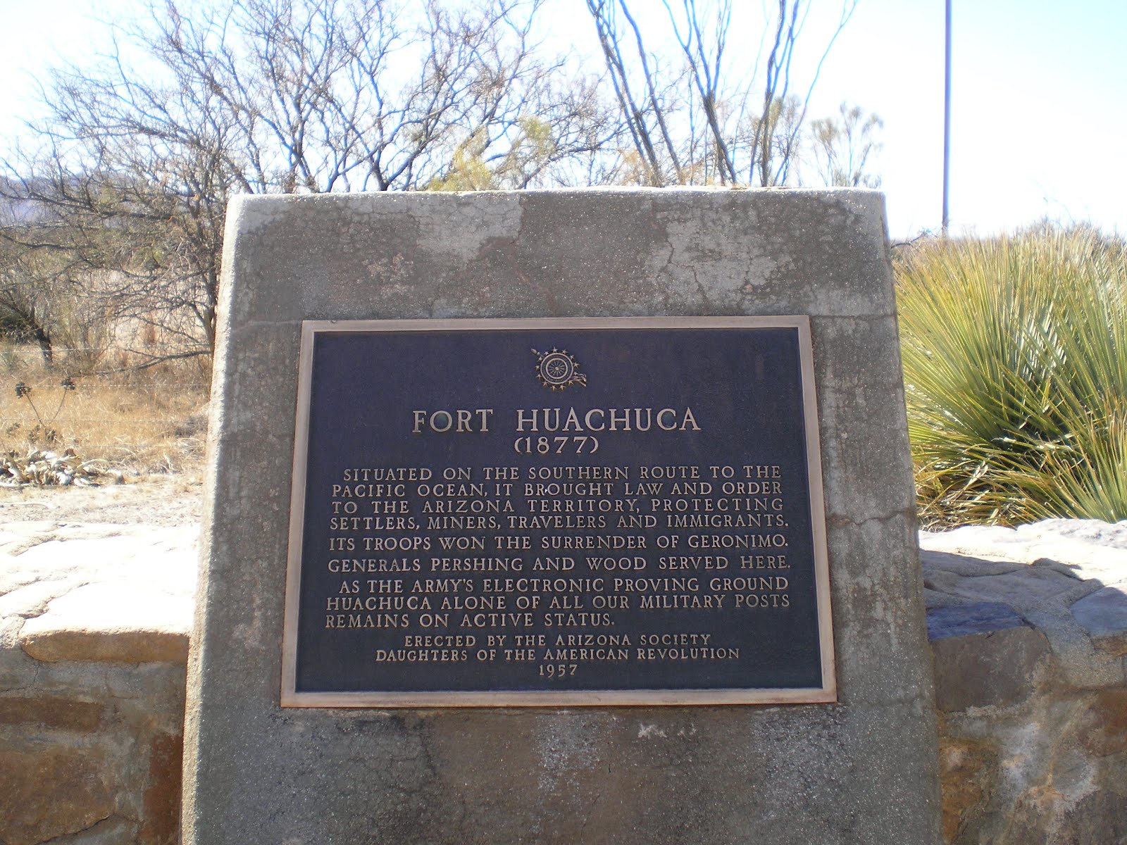
Fort Huachuca not only protected travelers, miners, and settlers, but troops from it were successful in getting Geronimo to "retire to a reservation" in Oklahoma.
--
Links:
- Wikipedia article on Nogales, AZ
- AZ State Park web page on Patagonia Lake
- Sonoita, which has several wineries nearby
- Wikipedia article on Apache chief Geronimo
Th 1 Mar Actual Route: Gilbert Ray CG - Tucson - Green Valley Walmart
F 2 Mar Actual Route: Green Valley Walmart - Tumacacori Mission - Rio Rico - Nogales - Patagonia Lake State Park
Sa 3 Mar Actual Route: Patagonia Lake SP - Sonoita - Huachuca City - Sierra Vista - Quail Ridge RV Park
Su 4 Mar Actual Route: Quail Ridge RV Park - Huachuca City - Sierra Vista - Huachuca City - Corte del Rey RV Park*
M 5 Mar Actual Route: Corte del Rey RV Park - Sierra Vista - Bisbee - Douglas - Douglas Walmart
T 6 Mar Actual Route: Douglas Walmart - Whitewater Draw WMA (near McNeal)
W 7 Mar Actual Route: Whitewater Draw WMA - McNeal - Elfrida - Sunizona - Chiricahua Natl Monument
Th 8 Mar Actual Route: Chiricahua Natl Monument - Ft Bowie NM - Bowie - Willcox
F 9 Mar Route: Willcox
Finding Campgrounds:
- RV Campgrounds from TrailerLifeDirectory.com
- Family Camping Directories from Woodalls.com
- Free campsites website
No comments:
Post a Comment