Thursday, July 26, 2012

Ruth Lake to Laytonville to Cleone, CA

Cleone, California     N.B.Some new photos added at the bottom of this post on T 31 Jul.


    A view of Ruth Reservoir from the dam on the Mad River in Trinity County.     Note the spin-fishermen at the right edge of the photo.


    The Mad River below Ruth Dam.


    A view through the trees from the Westside Road of a wide spot in 7-mile long Ruth Reservoir.


    Zooming in on a patch of the lake from about the end of the Westside Road.
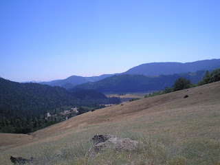


    Looking generally west from the crest of the Ruth-Zenia Rd.


    Several Trinity County mountain ranges.


    Note the ridge tops; the further south one travels in Northern California the less likely they will be tree-covered.


    Looking south (up) the Eel River near Alder Point.


    Looking downstream (north) on the Alder Point bridge over the Eel.


    One of the supports for the former Alder Point bridge; note the long-unused RR tracks to the left.


    An early evening shot south from the junction of Bell Springs and Alder Point Roads.


    The same shot as immediately above but taken the next morning; as you can see, the fog came in overnight.


    Panning right one can see one of the sources of moisture for the redwood belt.


    Second-growth redwoods.


    A photo down the Branscom Rd (Laytonville to near Westport on the coast); it's rather steep as one nears the coast.


    Just south of Westport.


--


Links:

--

T 24 Jul Actual Route: Shingletown - Redding - Buckhorn Summit - 17 mi E of Weaverville bd

W 25 Jul Actual Route: 17 mi E of Weaverville bd - Weaverville - Hayfork - Hyampom

Th 26 Jul Actual Route: Hyampom - Hayfork - Peanut - Forest Glen - HellGate USFS CG

F 27 Jul Actual Route: HellGate USFS CG - Ruth Lake - Zenia - Alder Point - Jcn Alder Point & Bell Sprs Rds bd

Sa 28 Jul Actual Route: Jcn Alder Point & Bell Sprs Rds bd - Garberville - Laytonville - Branscom - Cleone

Su 29 Jul Actual Route: Cleone - Fort Bragg - Cleone

M 30 Jul Actual Route: Cleone - Fort Bragg - Cleone

T 31 Jul Route: Cleone - Fort Bragg Lib - Cleone

--

Finding Campgrounds:

N.B. I receive nothing from Trailer Life, Woodalls, or FreeCampsites.net for including links to their free campground lookups.

Saturday, July 14, 2012

Lassen National Park - Chpt III

Shingletown, CA


    Mount Lassen as seen from a vista-point above Little Hot Springs Valley. Note the lack of snow as compared with the photos in my two previous passes through the park in posts on 2 and 8 Aug 2011.


    Panning right to cliffs somewhat yellow from the sulfate cyrstals....


    Panning farther right....


    Bumpass Mtn (elev: 8753').


    A view of the bottom of Little Hot Sprs Valley.


    On the left, Brokeout Mtn, remnant of a composite-type volcano which was perhaps 8 mi in diameter; Lassen Peak, formerly St. Joseph's Peak, formed c27,000 years ago on the northern side of Brokeoff Volcano. (Bumpass Mtn is on a nearer ridge.)


    Brokeoff and Bumpass Mtns again.
    If you're unwilling to take the word of a gelogist that Lassen Peak marks the southern end of the Cascade Range (Mt Garibaldi in British Columbia is at the northern end), note what botanists say about plants in Lassen Natl Park.

    Here's an interesting paragraph from the Lassen NP brochure. "Diversity abounds here because plant life mixes species from the Sierra Nevada to the south, the Cascade Range, and the Great Basin to the east. The park hosts nearly 800 plant species, whereas nearby Mount Shasta has only 485. In the park, 24 Sierrian species occur at the northern limit of their range, and 14 Cascadian species are at their southern limit."


    Lassen Peak as seen from the ESE.


    Reading Peak (8701').


    St. Joseph's Peak (aka Lassen Pk) as seen over the Kings Creek Meadow.
--


Links:

--

T 17 Jul Actual Route: La Porte Rd bd - Quincy - Paxton - Greenville - Chester - L Almanor CG

W 18 Jul Actual Route: L Almanor CG - Chester Lib - Childs Mdw - Lassen NP South Entrance - Summit L CG

Th 19 Jul Actual Route: Summit L CG - Viola - Shingletown

F 20 Jul Actual Route: Shingletown

Sa 21 Jul Actual Route: Shingletown

Su 22 Jul Actual Route: Shingletown

M 23 Jul Actual Route: Shingletown - Palo Cedro - Redding - Palo Cedro - Shingletown

T 24 Jul Actual Route: Shingletown - Redding - Buckhorn Summit - 17 mi E of Weaverville bd

W 25 Jul Actual Route: 17 mi E of Weaverville bd - Weaverville - Hayfork - Hyampom

Th 26 Jul Actual Route: Hyampom - Hayfork - Peanut - Forest Glen - HellGate USFS CG

F 27 Jul Actual Route: HellGate USFS CG - Ruth Lake - Zenia - Alder Point - Jcn Alder Point & Bell Sprs Rds bd

F 28 Jul Actual Route: Jcn Alder Point & Bell Sprs Rds bd - Garberville - Laytonville - Branscom - Cleone

--

Finding Campgrounds:

N.B. I receive nothing from Trailer Life, Woodalls, or FreeCampsites.net for including links to their free campground lookups.

Thursday, July 12, 2012

Mt Rose Pass, Washoe Lake & Lake Almanor

Lake Almanor's North Campground


    Repetition of some facts about Lake Tahoe but also some facts not listed in previous plaques; for instance, Tahoe is the 2d highest alpine lake in the world. [Click once to enlarge; press ESC to return here.]


    Mt Rose Pass has an elevation of 8911', not 8800' as one sign said -- though perhaps I misread 8900' as 8800'. In any case, I prefer exact numbers, not approximations or averages.
    Reason? Once a statistician drowned crossing a stream with an average depth of 1 foot.


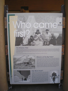
    Not one of the better plaques. Is there any doubt about who came first? Even Mark Twain would have been unlikely to make that claim after several belts in a Virginia City saloon. [But he might have claimed he could walk on water.]
    I'm sure that the body of the late Dr. James E. Church, a professor of classics and art history at the University of Nevada in Reno, has turned face-down after discovering his accomplishments are listed on a plaque below a paragraph which begins with the question "Where's all the trees?"


    While others may have had the same idea, a US Forest Service employee, Glen Hampton, gets credit for the idea.


    At 165 miles the Tahoe Rim Trail is slighly shorter than the John Muir Trail farther south in the Sierras. While I've walked parts of the latter, I've not walked any of the TRT. And since I walked primarily to find good fishing spots, there are likely more people than fish on or near the TRT.


    Washoe Lake as seen from NV431


    If you look closely in the center of the photo, you can see the Mt Rose Slide Bowl Ski Lift and 1 or 2 chairs.


    On my way to the Kings Beach Library and Martis Creek Campground near Truckee, I took this photo from a wide-out on NV431.


    Need to turn some of my tree-faller cousins loose on these trees to improve the view of the lake. :-)>


    Just after sunset at the Corps of Engineers Martis Creek Campground on CA237 near Truckee.


    An overhead cloud from the same spot used for the above shot.


    Since it was dark the last time I drove past the Lake Almanor Dam (aka, Canyon Dam) I stopped to take several photos during an afternoon.


    Panning right....


    Not sure if the building a short distance from the dam is call a guage station or not; and only one of the two jet ski which had been buzzing around is visible.


    Panning once again....


    Naturally there was no traffic on CA89 until I walked across it to take this photo down the North Fork of the Feather River. (Canyon Dam is listed at an elevation of 4590 ft.)
--


Links:

--

Su 15 Jul Actual Route: Martis Crk CG - Truckee - Cottonwood Creek USFS CG

M 16 Jul Actual Route: Cottonwood Creek USFS CG - Portola - E. Quincy - La Porte Rd bd

T 17 Jul Actual Route: La Porte Rd bd - Quincy - Paxton - Greenville - Chester - L Almanor CG

W 18 Jul Actual Route: L Almanor CG - Chester Lib - Childs Mdw - Lassen NP South Entrance - Summit L CG

Th 19 Jul Actual Route: Summit L CG - Viola - Shingletown

F 20 Jul Actual Route: Shingletown

Sa 21 Jul Route: Shingletown

--

Finding Campgrounds:

N.B. I receive nothing from Trailer Life, Woodalls, or FreeCampsites.net for including links to their free campground lookups.

Tuesday, July 10, 2012

Lake Tahoe & Mount Rose

Martis Creek COE Campground

    Mt Rose photos added Tuesday 17 Jul.
    After visiting Genoa earlier in the day on 8 July I drove up NV207 to Zephyr Cove and Nevada Beach, where I luckily got the last spot in the USFS campground since someone left a day early.
    After walking part-way to the beach from the campground I returned to my camper for a hat since the wind was beginning to pick up. As a result, this 1st photo is slighltly after sunset.


    I turned and took this shot down the SE shore of Lake Tahoe at or near Zephyr Cove.


    Panning right, this view is toward the California town or city of South Lake Tahoe as well as the Sierra Nevada Range to the south.


    Panning right there are still a few rays of sunlight on the Sierras.


    Panning farther right, it appears this couple is looking at their iPhone or digital camera; prior to that they were trying to convince a Canadian Goose, a gander, to "take a hike," but the goose bowed his neck and stood his ground.


    Panning right I returned to the spot where the sun has just set. There were a few small clouds just above where the sun had been, but they're barely visible.


    Panning right yet again, the Nevada (or east) shore of Tahoe appears.


    Another unamed wildflower which, if memory serves, is in Sierra Nevada Natural History by Storer and Usinger. [Incidentally, two previously unidentified photos taken while driving through Oregon and Central Nevada were on a wall poster in the Truckee Library next to the stairwell for the iron circular stairs; they were, in Oregon, Creeping Phlox, and in Nevada, a Prickly Poppy.]


    From NV431, the Incline Village to Mt Rose to Reno road.


    Panning right the huge size of Lake Tahoe doesn't quite fit in this photo.


    Likely Dollar Point rather than Stateline Point.


    A closeup of the golf courses in Kings Beach and/or Brockaway, CA, as well as one high-rise hotel.


    [Click once to enlarge; press ESC to return here.]
--


    Slide Mountain's antennas as seen from the Mt Rose USFS Campground.


    Mt Rose Summit (elev: 8800') on NV431 from Incline Village to Reno.


    A view to the NW from Mt Rose Summit's large parking lot.


    Mount Rose (10,778'). While not the highest peak in Nevada, it does dominate the Northern Tahoe Region.


    A photo looking toward Reno from the Mt Rose Road.


    Another look toward a closer Reno.
--


Links:

--