Lake Almanor's North Campground
Repetition of some facts about Lake Tahoe but also some facts not listed in previous plaques; for instance, Tahoe is the 2d highest alpine lake in the world. [Click once to enlarge; press ESC to return here.]
Mt Rose Pass has an elevation of 8911', not 8800' as one sign said -- though perhaps I misread 8900' as 8800'. In any case, I prefer exact numbers, not approximations or averages.
Reason? Once a statistician drowned crossing a stream with an average depth of 1 foot.
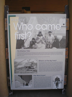
Not one of the better plaques. Is there any doubt about who came first? Even Mark Twain would have been unlikely to make that claim after several belts in a Virginia City saloon. [But he might have claimed he could walk on water.]
I'm sure that the body of the late Dr. James E. Church, a professor of classics and art history at the University of Nevada in Reno, has turned face-down after discovering his accomplishments are listed on a plaque below a paragraph which begins with the question "Where's all the trees?"
While others may have had the same idea, a US Forest Service employee, Glen Hampton, gets credit for the idea.
At 165 miles the Tahoe Rim Trail is slighly shorter than the John Muir Trail farther south in the Sierras. While I've walked parts of the latter, I've not walked any of the TRT. And since I walked primarily to find good fishing spots, there are likely more people than fish on or near the TRT.
Washoe Lake as seen from NV431
If you look closely in the center of the photo, you can see the Mt Rose Slide Bowl Ski Lift and 1 or 2 chairs.
On my way to the Kings Beach Library and Martis Creek Campground near Truckee, I took this photo from a wide-out on NV431.
Need to turn some of my tree-faller cousins loose on these trees to improve the view of the lake. :-)>
Just after sunset at the Corps of Engineers Martis Creek Campground on CA237 near Truckee.
An overhead cloud from the same spot used for the above shot.
Since it was dark the last time I drove past the Lake Almanor Dam (aka, Canyon Dam) I stopped to take several photos during an afternoon.
Not sure if the building a short distance from the dam is call a guage station or not; and only one of the two jet ski which had been buzzing around is visible.
Naturally there was no traffic on CA89 until I walked across it to take this photo down the North Fork of the Feather River. (Canyon Dam is listed at an elevation of 4590 ft.)
--
Links:
- Wikipedia article on Washoe Lake State Park
- OnlineNevada.Org biography of Dr. James E. Church
- Tahoe Rim Trail website
- History of Lake Almanor
Su 15 Jul Actual Route: Martis Crk CG - Truckee - Cottonwood Creek USFS CG
M 16 Jul Actual Route: Cottonwood Creek USFS CG - Portola - E. Quincy - La Porte Rd bd
T 17 Jul Actual Route: La Porte Rd bd - Quincy - Paxton - Greenville - Chester - L Almanor CG
W 18 Jul Actual Route: L Almanor CG - Chester Lib - Childs Mdw - Lassen NP South Entrance - Summit L CG
Th 19 Jul Actual Route: Summit L CG - Viola - Shingletown
F 20 Jul Actual Route: Shingletown
Sa 21 Jul Route: Shingletown
Finding Campgrounds:
- RV Campgrounds from TrailerLifeDirectory.com
- Family Camping Directories from Woodalls.com
- Free campsites website
- Info on finding BLM Campgrounds


No comments:
Post a Comment