Mt. Rose USFS Campground
About 3/4 miles east of Middlegate on US50 is the "Shoe Tree." Obviously those with a lot of time on their hands tossed their tennis/athletic shoes into the branches of this cottonwood. [Click once to enlarge; press ESC to return here.]
And to reach the top branches of the Shoe Tree, those tossing had to have strong arms, a little luck, and/or excess time.
And those in a hurry chose the lower branches. [N.B. I didn't see a single pair of Florsheim wingtips in the Shoe Tree.]
A first glimpse of Sand Mountain Recreational Area east of Fallon on US50.
As the shadows began to lengthen, I took another photo of Sand Mtn. (When I first arrived a fellow of Oriental extraction was furiously waving his arms trying to attract my attention. Drove to where he was and his small front-wheel drive rental was stuck up to the front bumper. Since I didn't have a tow rope, I drove to the only other person at Sand Mtn, a young fellow named Travis who confessed that he had gotten his moderate-sized 5th wheeler stuck. He pulled the fellow with the rental out with his 3/4 ton 4x4.)
Panning left to the tail-end of Sand Mtn. Since it was 3 July, I expected quite a few people with OHV [Off Highway Vehicles] to show up the next day.
A view south across US50 of Salt Wells Basin.
Travis put on quite a show, riding his motorcycle several times to near the crest of the huge sand dune -- the last time in near darkness. The next morning, the couple who had parked their large 5th Wheeler next to me and who have been full-timing since 2003 told me about Escapees, a Texas-based club for full-timers. Leonard, the full-timer, remarked that Travis was a very skilled rider. Theoretically the sand is soft if you fall, but there's aways a chance that your vehicle lands on top of you.
A sunset from the Sage Valley RV Park about two miles west of Fallon on US50.
A plaque outlining Fort Churchill & enviorns; it was a U.S. Army post from 1860-69 on the banks of the Carson River and near both a Pony Express Station and other mail routes.
The buildings were on the perhiphery of a square. (See above plaque.)
As you can see by the distance between building, there was a large parade grounds in the center.
While the Signal Corps did have observation balloons prior to the Civil War, if mem serves, I suspect that the view of the post is an illustration.
Here's the hill shown in the illustration.
At least for officers, Fort Churchills was considered a good duty post; and the hospital and surgeon were likely part of that favorable judgment.
The state of Nevada is maintaing Fort Churchill, named after the Army Inspector General at the time, in a "state of arrested decay."
Captain Joseph Stewart thought the officers' wives could do their laundry, but apparently he grudgingly gave in to requests for laundresses.
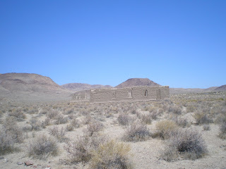
The adobe bricks were made locally and set on stone foundations.
It's difficult to remember all of the buildings, but one of the smaller ones was Capt Stewart's headquarters.
Here are a cluster of buildings, with the one on the right being at the NE corner of the square.
Note that some of these building were two-story.
A plaque which notes that between 1860-61 the Pony Express stopped "momentarily" at the Ft Churchill HQ.
Capt Stewart's post headquarters.
Had no more room in my camera's memory for additional photos, but I do remember some of the things on the plaques. The disparity between the offiers's quarters, which were two-story buildings, many of which remain today, and the barracks where the enlisted men lived, very few of which survived to today, was wide. I suspect that the beds in the former quarters were purchased in San Francisco whereas the troops had bed sacks stuffed with straw. [There's an old army acronym: RHIP, "Rank has its privileges."]
Since there was a store on post operated by a local merchant, the troops could no doubt purchase firewater using part of their $13 monthly pay. The stockade's main inhabitants were men who got drunk. During the day they had hard labor and at night they were encumbered by shackles.
For more on the incidents which led to the construction of Fort Churchill, see the Links below.
When driving to Ft Churchill avoid Ft Churchill Rd from US50 to the west side of the park; it's the roughest road I've seen in 56 years of driving, many of those in the Sierra Nevada.
--
Links:
- Online Nevada Encyclopedia history of the Pyramid Lake War
- Wikipedia article on the Paiute or Pyramid Lake War
- Nevada State Parks web pages on Fort Churchill
Su 8 Jul Actual Route: Carson City Walmart - C.C. McDonalds - Genoa - Minden - Nevada Beach CG, Zephyr Cove
M 9 Jul Actual Route: Nevada Beach CG - So L Tahoe - Incline Village, NV - Kings Beach, CA - Incline Village - Mt Rose CG
T 10 Jul Actual Route: Mt Rose CG - South Valley Lib (Reno) - Mt Rose CG
W 11 Jul Actual Route: Mt Rose CG - South Valley Lib (Reno) - Mt Rose CG
Th 12 Jul Actual Route: Mt Rose CG - South Valley Lib (Reno) - Mt Rose CG - Kings Beach, CA - Martis Crk CofEng CG
F 13 Jul Actual Route: Martis Crk CofEng CG - Truckee - Martis Crk CofEng CG
Sa 14 Jul Actual Route: Martis Crk CofEng CG - Truckee - Martis Crk CofEng CG
Su 15 Jul Route: Martis Crk CG - Truckee - Little Truckee USFS CG
Finding Campgrounds:
- RV Campgrounds from TrailerLifeDirectory.com
- Family Camping Directories from Woodalls.com
- Free campsites website
- Info on finding BLM Campgrounds


No comments:
Post a Comment