Sonora Library, CA
 Here's the first of several plaques on the original Minaret Summit (elev: 9265'), the third-highest pass over the Sierra Nevada after Tioga and Sonora Passes. [Click once to enlarge; press ESC to return here.]
But since the road over Minaret Summit dead-ends at Reds Meadow,
Sherman Pass on the western edge of the Kern Plateau is considered #3.
Here's the first of several plaques on the original Minaret Summit (elev: 9265'), the third-highest pass over the Sierra Nevada after Tioga and Sonora Passes. [Click once to enlarge; press ESC to return here.]
But since the road over Minaret Summit dead-ends at Reds Meadow,
Sherman Pass on the western edge of the Kern Plateau is considered #3.

This plaque ends with the implication that just fishing the Middle Fork of the San Joaquin is a reward in itself even if you don't catch anything.
Bullroar! I'm an old-school troglodyte who likes to eat trout even more than I like to catch them!

Both the John Muir Trail, from Tuolumne Meadows in Yosemite National Park to Mt Whitney, and the Pacific Crest Trail, from the Mexican to Canadian borders, pass through Devils Postpile.

What formerly was called the Minarets is now apparently called the Ritter Range after Mt Ritter, a peak near Thousand Island and Garnet Lakes, and the Minarets are part of that range.

Originally part of Yosemite National Park, Devils Postpile lost its protection when mining interests were successful in having it separated. When their plans to dynamite the Postpile to provide material for a dam across the Middle Fork of the San Joaquin became known, public opposition convinced President Taft to declare it a National Monument in 1911.

Twenty years ago the Rainbow Fire consumed 8765 acres. A lightning strike on 12 Aug 1992 apparently did not ignite anything; but 8 days later a plume of smoke showed up. Add to that 60mph winds and the result was that over 7000 people were evacuated from campgrounds and the wilderness.

As both the Park and U.S. Forest Services have learned, the old policy of putting all fires out ASAP eventually resulted in much larger fires in the future. The Native Americans periodically burned underbrush, the main culprit is helping a ground fire become a crown fire which sometimes roars up a hill and them explodes in three directions at the top. Saw that first-hand while working for the US Forest service during the summer of 1960.

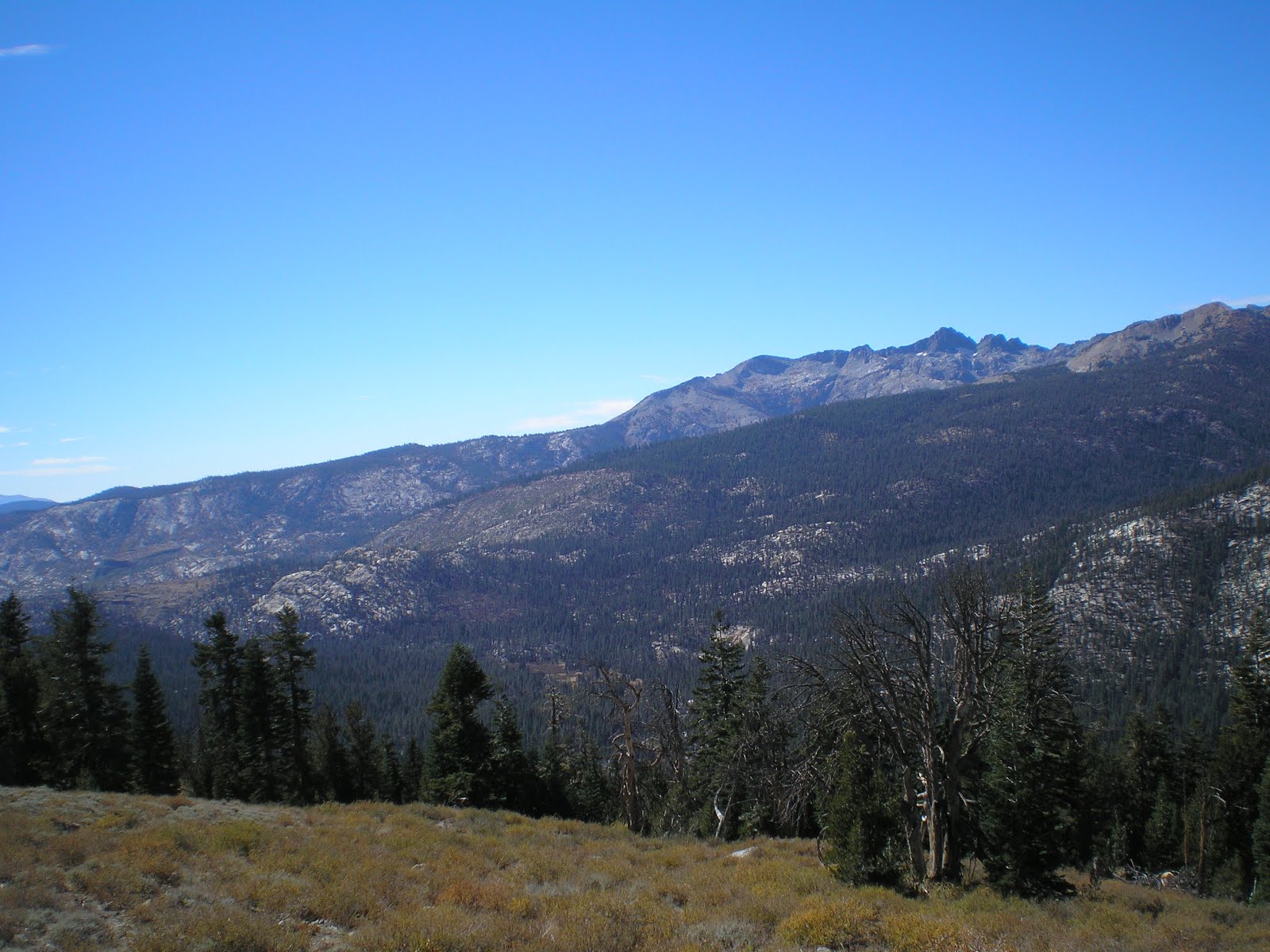
Looking down the Middle Fork of the San Joaquin toward the Silver Divide, one of the few mountain ranges which runs east-to-west rather than north-to-south.

On the back side of Minaret Summit, a view to the east.

Panning right and shooting over the wooded basin where Mammoth Lakes is located.
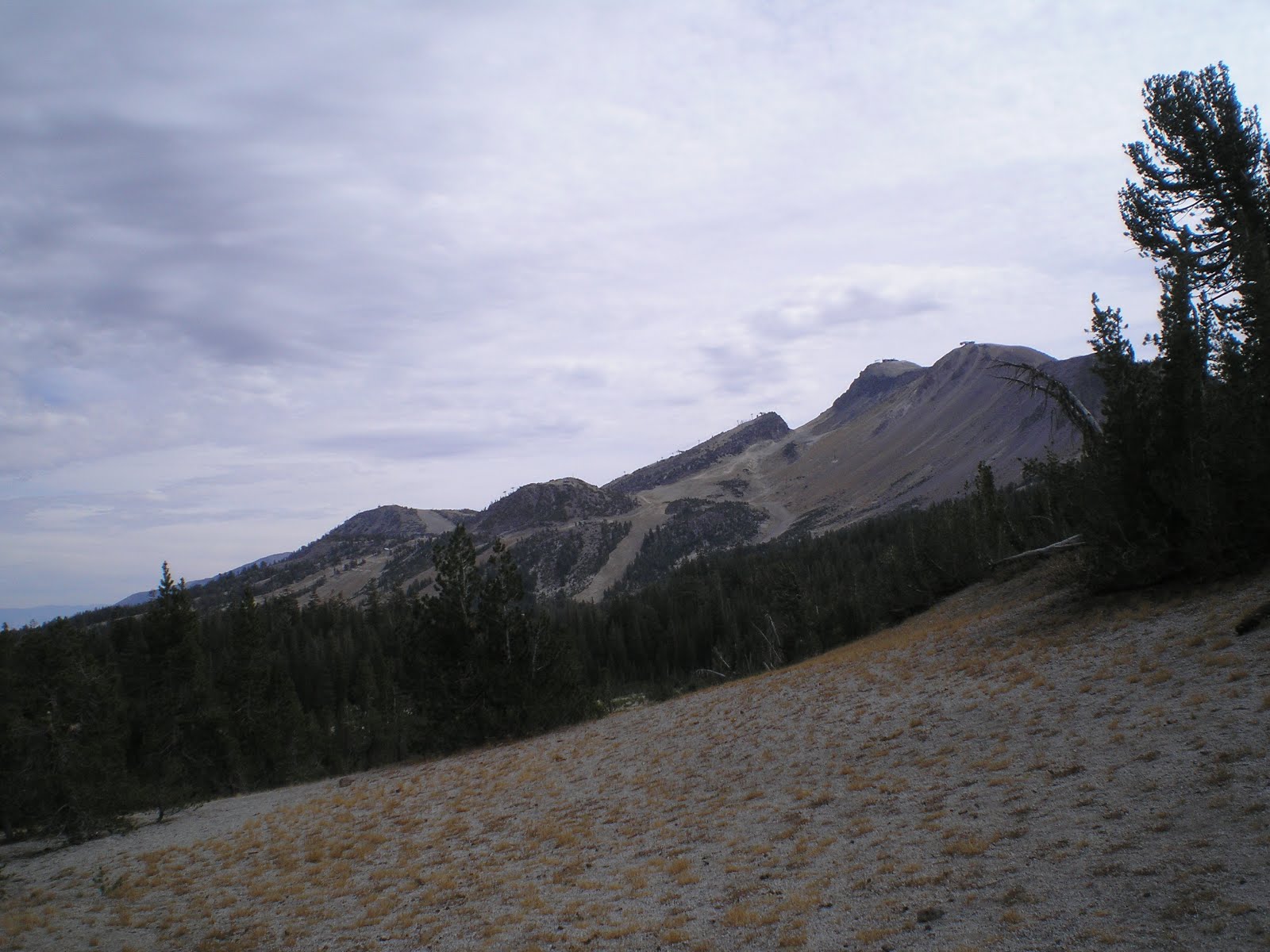
Panning further right, the eastern edge of Mammoth Mountain comes into view.

Zooming in, one can see the several ski lifts/gondolas on Mammoth Mountain.

Devils Postpile, which is 0.4 miles from the Ranger Station. There is a slight climb, but a ramp has been built around the only stair. [Click once to enlarge; press ESC to return here.]

A basalt lava eruption less than 100,000 years ago about two miles upstream from the current location was that start of Devils Postpile. Because the basalt had a mineral composition which was consistent, it form symmetrical vertical and hexagonal columns.

During the last ice age, 20,000 to 12,000 years ago a glacier flowed down the Middle Fork of the San Joaquin and overrode the fractured mass of lava; it carved away one side of the postpile, exposing a sheer wall of cloumns 60 feet high.

The rubble pile you see at the foot of the postpile is the result of erosion by various forces as well as earthquakes.

[Click once to enlarge; press ESC to return here.]

If your Ouiji Board says today is the time for a major quake in the Mammoth Lakes Area, which is still active volcanically, don't stand where I too this photo! :-)>

Here's a photo of what I remember from my last visit to Devils Postpile in 1965, when I arrived on foot with 15 trout I had caught in Minaret Creek. I gave my dad the fish, took on two more weeks of dehydrated food, hitched a ride with them to Reds Meadow Pack Station, and hit the trail for Lake Edison. [As it turned out, that 28-day trip was the backpack trip of a lifetime.]

On my departure from Devils Postpile I again stopped at Minaret Summit. This view is to the NW into Yosemite National Park.

Panning left, a better-lit Ritter Range including the Minarets is seen; Mt Ritter is the sharper of the two peaks on the right.

Panning left again, the Minarets are still visit in the center of the Ritter Range.
Panning yet again, Summit Meadow near the southern end of the Ritter Range is where Gov. Ronald Regan chose in 1972 to announce President Richard M. Nixon's decision to scrap any further plans for a trans-Sierra highway through the heart of the Sierra Nevada.

The darker-colored range running east-to-west is the Silver Divide, one of the few "transverse mountain ranges" in California.

A shot over my rig at Mammoth Mountain.
--
Links:
- National Park Service website on Devils Postpile National Monument
- Wikipedia article on Devils Postpile
- Devils Postpile Photo Gallery
--
F 5 Oct Actual Route: Pleasant Valley CG - Mammoth Lakes - Devils Postpile Natl Monument - Reds Meadow USFS CG
Sa 6 Oct Actual Route: Reds Meadow CG - Minaret Summit - Mammoth Lakes Library - Lee Vining - Junction USFS Campground
Su 7 Oct Actual Route: Junction CG - Saddlebag Lake - Junction CG - Tuolumne Mdws - Hogdon USPS Campround
M 8 Oct Actual Route: Hogdon CG - Cherry Valley - Tuolumne Lib - N.F. Tuolumne River bd
T 9 Oct Actual Route: Tuolumne River bd - Tuolumne - Sonora - Tuolumne River bd
W 10 Oct Actual Route: Tuolumne River bd - Tuolumne - Sonora - Tuolumne River bd
Th 11 Oct Actual Route: Tuolumne River bd - Tuolumne - Sonora - Tuolumne River bd
F 12 Oct Actual Route: Tuolumne River bd - Tuolumne - Sonora - Tuolumne River bd
Sa 13 Oct Actual Route: Tuolumne River bd - Tuolumne - Sonora - Oakdale - Woodward Resv CG
Su 14 Oct Actual Route: Woodward Resv CG - Oakdale - Tuolumne Lib - Tuolumne River bd
M 15 Oct Actual Route: Tuolumne River bd - Tuolumne Lib - Twain Harte Laudromat - Tuolumne River bd
T 16 Oct Actual Route: Tuolumne River bd - Sonora Lib - Tuolumne River bd
W 17 Oct Route: Tuolumne River bd - Soulsbyville - Sonora Lib - Tuolumne River bd
--
Finding Campgrounds:
- RV Campgrounds from TrailerLifeDirectory.com
- Family Camping Directories from Woodalls.com
- Free campsites website
- Info on finding BLM Campgrounds
No comments:
Post a Comment