North Lake USFS Campground, CA

Heading down toward the South Fork of the Kern River and the small community of Kennedy Meadows.

Note that the trees are now Pinon Pines and Utah Junipers rather than Lodgepole and Ponderosa Pines as at Troy Meadows.

A morning shot of the crest of the Sierra Nevada from the Inyo County Portagee Joe Campground, with Mt. Whitney to the left and a nearly-full moon to the right.

Zooming in on the highest peak in the contiguous 48 states at 14,495 feet.

From a wide-out on the Big Pine Creek Road a view the next morning of a slightly-smaller moon above the two peaks at the top of the canyon.

From the Westgard Pass road, CA168, looking across the Owens Valley at the eastern side of the Sierra Nevada in the vicinity of Big Pine Creek. Note the several glaciers which provided the name for Glacier Lodge, where reknown mountaineer Norman Clyde was a caretaker for many years.

A plateau on the Westgard Pass Road not too far from where the road to the Bristlecone Forest branches north.

Panning left to a vista mainly of sagebrush, pinon pines, and Utah Junipers.

From a Vista Point past the Grandview Campground, a shot to the north up the Chalfant Valley on the right and the top of the Owens Valley at Sherwin Grade on the left.

Panning left, a hazy view of the eastern scarp of the Sierra Nevada as well as Bishop at the top of the Owens Valley.

Despite the haze over the Owens Valley, will continue to pan left.

Panning left to the area of the Palisades near the head of Big Pine Creek.

Panning left to a sink basin on or near the northern boundary of Death Valley National Park.

Roughly two miles past the Schulman Visitor Center I stopped to eat lunch; first, however, I took this photo of White Mountain.

Zooming in, one can see the top of White Mountain (elev: 14,246') more clearly.

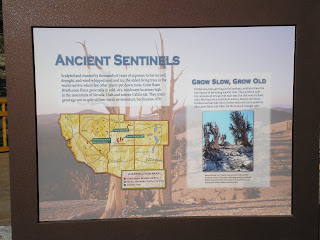
After lunch I walked to a nearby bristlecone pine which was only partially alive.

Bristlecones have the ability to shut down growth in part of their tree in order to preserve growth elsewhere.

One inch of new wood or growth may take 100 to 300 years.

As a guess this "young whippersnapper" is probably 500 to 1000 years old.

The east side of the tree showing most of the dead wood; growth in generally best on north-facing slopes. Like sequoias, bristlecones have no tap roots but may send out roots 1-2 feet underground for as far as 50 feet.

Another look at White Mountain as I walked back to my rig. I first learned of dendrology when I subscribed to Cycles magazine after becoming interested in stock market cycles. There were several articles on tree ring studies, especially those done by researchers from the Uninversity of Arizona. Dr. Andrew E. Douglass (1867-1962), a mathematician and astronomer, felt that solar activity affected earth's weather; and he studied tree rings in the Show Low area of Arizona to confirm his hypothesis.


[Click once to enlarge; press ESC to return here.]

In addition to Drs Douglass and Schulman two other PhDs helped advance the science of dendrochronology: Dr. Weslley Ferguson, who found that dead wood tree rings could extend tree-ring history even further back in time, and Dr. Henry Michael (1912-2006), who helped rectify errors in radio carbondating through the use of tree-ring history which now extends back to the last Ice Age 12,000 years ago.

A maps of the Ancient Bristlecone Pine Forest. [Click once to enlarge; press ESC to return here.]

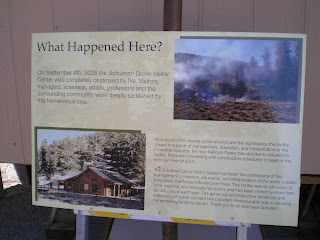
Plaque explaining the destruction by arson of the Schulman Grove Visitor Center and its reconstruction.
--
Links:
- Wikipedia article on the Ancient Bristlecone Pine Forest
- U.S. Forest Service website on the Bristlecone Pine Forest
- Wikipedia article on dendrochronology
- Laboratory of Tree-Ring Research at the University of Arizona
T 2 Oct Actual Route: Big Pine Crk bd - Big Pine - Ancient Bristlecone Pine Forest - Grandview USFS CG
W 3 Oct Actual Route: Grandview USFS CG - Big Pine - Bishop - Bishop Crk - North Lake USFS CG
Th 4 Oct Actual Route: North Lake USFS CG - Bishop Senior Center - Pleasant Valley Inyo County CG
F 5 Oct Actual Route: Pleasant Valley CG - Mammoth Lakes - Devils Postpile Natl Monument - Reds Meadow USFS CG
Sa 6 Oct Actual Route: Reds Meadow CG - Minaret Summit - Mammoth Lakes Library - Lee Vining - Junction USFS Campground
Su 7 Oct Actual Route: Junction CG - Saddlebag Lake - Junction CG - Tuolumne Mdws - Hogdon USPS Campround
M 8 Oct Actual Route: Hogdon CG - Cherry Valley - Tuolumne Lib - N.F. Tuolumne River bd
T 9 Oct Actual Route: Tuolumne River bd - Tuolumne - Sonora - Tuolumne River bd
W 10 Oct Route: Tuolumne River bd - Tuolumne - Sonora - Tuolumne River bd
--
Finding Campgrounds:
- RV Campgrounds from TrailerLifeDirectory.com
- Family Camping Directories from Woodalls.com
- Free campsites website
- Info on finding BLM Campgrounds


No comments:
Post a Comment