Monday, August 26, 2013

A Shackelford Obituary: Alice Dorothy Shackelford Fowler Wofford

Alice Dorothy Shackelford Fowler Wofford

San Angelo, TX, Library

--
Obituary
--
Monday 25 November 1985 The Lawton Constitution, p. 6A
--
    [The] funeral for Alice Dorothy Wofford, 72, of 620 E, is pending with Ritter Dalton Funeral Home.
    Mrs. Wofford died Sunday in a Lawton hospital after a lengthy illness.
    She was born July 10, 1913, in San Angelo, Texas. Shw was married to the late Paul Wofford in 1945, in Kingville, Texas. She was a retired beautician. She grew up in Corpus Christi, Texas, and moved to Alice, Texas in 1935. She had lived in Lawton since January 1985. She was a member of the First Christian Church and the VFW Ladies Auxiliary.
    Survivors include two daughters, Sylvia A. Rogers, Lawton, and Alice D. Chisholm, Portland, Texas, three grandchildren and four great-grandchildren. .......................................................................


Links:
Return to Top of Page

T 24 Sep Actual Route: Dodge City W/M - John's Body Shop - DC Lib - Bucklin Lib - Sitka bd

W 25 Sep Actual Route: Sitka, KS bd - Woodward, OK, McDs - Lib - Walmart

Th 26 Sep Actual Route: Woodward W/M - Lib - Clinton McDs - Jcn OK33/US183 bd

F 27 Sep Actual Route: Jcn OK33/US183 bd - Clinton - Hobert Lib - Synder - Lawton Walmart

Sa 28 Sep Actual Route: Lawton W/M - Wichita Falls W/M

Su 29 Sep Actual Route: Wichita Falls, TX, W/M - Wichita Falls Visitor Ctr - Seymour - Throckmorton - Ft Griffin SP CG

M 30 Sep Actual Route: Ft Griffin SP CG - Albany Lib - P.O. - Abilene Lib - Walmart

T 1 Oct Actual Route: Abilene Walmart - Mockingbird Ln Br Lib - Sweetwater McDs - Walmart

W 2 Oct Actual Route: Sweetwater Walmart - McDs - Big Spring VA Hosp - Howard County Lib - US87 bd

Th 3 Oct Route: US87 bd - Sterling City, TX, - San Angelo Lib - Sherwood Way Walmart


Finding Campgrounds:

N.B. I receive nothing from Trailer Life, Woodalls, or FreeCampsites.net for including links to their free campground lookups.

Monday, August 19, 2013

A Surprise Heart Attack?

A Surprise Heart Attack?

Johns Body Shop*, Dodge City, Kansas

    [If you'd like to skip the story on my heart attack but read my recommendations, scroll to the last section below just above the Links.]
    Because I inherited most of my mother's maladies, including Raynald's Disease [formerly Rayneaux Disease] and cellulitis, and had been fit enough to backpack in the mountains of California for 53 years, I assumed I had not inherited my father's congestive heart failure, which led to his death via aspiration pneumonia after he fell and broke his hip in 2005.
    After my father had a triple bypass the day before his 85th birthday in 2001 I learned that 3 of my 4 siblings were taking heart medications -- each a different type.

    On Friday 6 September I returned to Mesa Verda National Park, where I had nearly run out of gas in March 2012 and had only taken one photo of the cliff dwellings. [See links below.]
    The Spruce Tree House is perhaps the best of the 13th century dwellings; so I walked down the paved path to it. After talking with 3 different park rangers, in part about the summers I worked for the U.S. Forest Service while attending college, I headed back up the path out of the canyon. Never was "gassed" even though I have the equivalent of slightly less than one lung; paused as necessary and to take advantage of any shade.
    Also toured the Visitor Center and particularly enjoyed the dendrochronology display, which explained how tree rings could be used to approximate the date some of the cliff dwellings were built. Since a ranger down in the canyon has said that the Mesa Loop provided many photo opportunities without much walking, I headed there.

    After taking a few photos I parked my camper to eat lunch. While eating my favorite snack, Rice Crackers, a sharp pain hit me in the middle of the chest. And my arms and hands became numb. Massaging my chest or clinching my fingers into a fist did not seem to have much of an effect on the chest pain or numbness. After 5-6 minutes I began breathing deeply. That caused the pain to abate somewhat.
    Finally decided I didn't want to eat and continued on around the Mesa Loop. By the time I got to a what I thought was a smaller sub-loop off of the Mesa Loop, I was feeling considerably better. So I turned onto that sub-loop. That was a mistake, for the loop was longer than I realized and, though the chest pain did not return, the numbness in my arms and hands waxed and waned. While I did see a couple of Park Service vehicles, I saw no rangers. So I decided to drive to the Far View Visitor Center.

    As it turned out, the Far View Visitor Center closed the day after Labor Day. I walked around a bit, and the fresh air seemed to help. When a couple parked at the other end of the parking lot, I drove down and explained what had happened. The fellow doubted that his cell phone would work there and suggested I go to the the Far View Lodge and have them call paramedics. But the longer I talked in the fresh air, the better I felt. Finally I told them I'd drive down to the Mayfield Village, which has WiFi and in whose campground I stayed the night of the 5th.
    While there was occasional numbness as I drove to the lower elevation, the chest pain never returned. The girl who had checked me into a campsite the night before offered to call paramedics for me. However, since Cortez was only 14 miles away, I asked her for the name of the hospital so that I could use Mapquest to get driving directions.

    As I approached the Emergency Entrance to the Southwest Memorial Hospital a doctor and a nurse were leaving. I explained what happened and said that I thought my mycobacterium avium might have been the cause of the chest pains. She was a bit of a comedienne and claimed she had never heard of it. After a bit, she got serious and took me inside to where I could be admitted to the ER.

    The male nurse, Keith, was born in Augusta, Ga, near my first duty station in the army; and he had also been to Ft Monmouth, my second duty station. A nurse came in with and EKG/ECG, which showed no evidence of a heart attack. Dr. Zajchowski [Call me Dr Z] seemed to buy my explanation that my lungs were the cause of the chest pains. Eventually, however, a blood test came back and Dr Z said that I had indeed had a heart attack. But since they had no cardiologist on their staff, he was recommending that I be transferred to the Durango, CO, Hospital.
    I balked for four reasons: 1)I felt I would receive better care at a VA Hospital than a for-profit hospital; 2)costs would be lower at the former; 3)my F250 and slide-in camper would be with me at a VA Hospital; and 4)the chest pains had not returned.

    I had to wait until Monday 9 Sep to pick up some forwarded mail at the Cortez Post Office -- though I could have either had it returned to the Escapees Mail Service or forwarded to the Albuquerque Post Office. Became somewhat concerned on Su 8 Sep when my upper arms became somewhat numb while I ate lunch in the empty Cortez Library parking Lot. But after cutting a 325mg aspirin in half and swallowing one-half, that + a walk for a couple of loops about the parking lot made me feel better.

    Finally, after picking up my forwarded mail on M 9 Sep I was on my way to the Albuquerque VA Hospital. After boondocking near Cuba, NM, Monday night I continued on to Albuquerque. It took a while to find the VA Hospital, in part because their VA logo on one of their taller buildings was not that visible through the rain. I ran into a VA police officer on my way to the Business Office; he assured me that my rig would not be a problem as long as it was parked properly. After completing the paper work at the Business Office, I was admitted to the ER. And then the "fun" began.
    The ER nurse wasn't kidding when she said that the diuretic she gave me was very effective. My bladder was full in less than 7 or 8 minutes. And the next four hours, until a "pulley catheter" was installed, were the most painful I've ever spent in any hospital. As those of you who have been in ERs know, it's difficult to sleep because the nurses keep waking you up to take measurements, draw blood, etc.

    Eventually, after a few more preliminaries, Paul, the nurse for the cardiology unit wheeled me from the hospital room where I had been staying. While wheeling me he stated the obvious, "You know, you could have died [while driving here]." My retort was that I had been a commodity broker for 28 years and thought I was fairly capable of assessing risk. Of course, with my life at stake I put a lot of faith in aspirin to keep my blood thin until the cause of the chest pain was determined.
    To make a long story short, there was a build-up of plaque in the Left Anterior Descending Artery near the top of my heart. Dr Sheldon, reputedly the best surgeon, removed the build-up and installed a stent. I remained in Albuquerque for 3 days to see if there were any after-effects, but other than some slight numbness in my hands and arms, which used to occur when the weather was cold because of my Raynald's Disease, there were no problems.

    Conclusion: I should have had a stress-test of my cardiovascular system after I quit backpacking in 2008. Even if neither of your parents had heart disease, I strongly suggest that you have such a test if you are 55 or older. And, as you can see from my experience, when one of your parents had heart disease, you may be at risk even if you think, as I did, that you are in good physical condition, don't smoke, aren't overweight, or do not have diabetes.


     * = John Trabert of John's Body Shop in Dodge City, KS, did an excellent job of bending the top of my right door back in position after I hit the bottom of that door on an old concrete light standard.
Links:
Return to Top of Page

T 24 Sep Actual Route: Dodge City W/M - John's Body Shop - DC Lib - Bucklin Lib - Sitka bd

W 25 Sep Actual Route: Sitka, KS bd - Woodward, OK, McDs - Lib - Walmart

Th 26 Sep Actual Route: Woodward W/M - Lib - Clinton McDs - Jcn OK33/US183 bd

F 27 Sep Actual Route: Jcn OK33/US183 bd - Clinton - Hobert Lib - Synder - Lawton Walmart

Sa 28 Sep Actual Route: Lawton W/M - Wichita Falls W/M

Su 29 Sep Actual Route: Wichita Falls, TX, W/M - Wichita Falls Visitor Ctr - Seymour - Throckmorton - Ft Griffin SP CG

M 30 Sep Actual Route: Ft Griffin SP CG - Albany Lib - P.O. - Abilene Lib - Walmart

T 1 Oct Actual Route: Abilene Walmart - Mockingbird Ln Br Lib - Sweetwater McDs - Walmart

W 2 Oct Actual Route: Sweetwater Walmart - McDs - Big Spring VA Hosp - Howard County Lib - US87 bd

Th 3 Oct Route: US87 bd - Sterling City, TX, - San Angelo Lib - Sherwood Way Walmart


Finding Campgrounds:

N.B. I receive nothing from Trailer Life, Woodalls, or FreeCampsites.net for including links to their free campground lookups.

Monday, August 12, 2013

Devils Tower National Monument, Wyoming

Devils Tower National Monument, Wyoming

Pagosa Springs Library, Colorado


    [Due to a health problem I spent 3 days in the Albuquerque VA Medical Center; will have more to say about it in a separate post, now one-half complete, to this blog.]

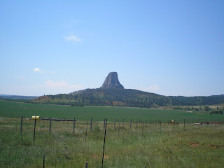
    As one approaches Devils Tower from the south on WY24 & WY110 there are very few places to take a photo of tower until you are very close. But the woman who managed the campground said there were much better spots when one approached the tower from Hulett to the north-east. [These photos were taken on 26 & 27 July.]


    Colonel Richard Dodge, who, like Lt Col George Custer, was leading an expedition to investigate reports of gold discovery in the Black Hills, named this monolith Devils Tower while Indian tribes had several names for it, among which was Bear Lodge.


    It easy to see why plains Indians felt Devils Tower was unique -- mainly because it stands out in the flat lands of Wyoming, Montana, and South Dakota.


    The first view from WY24 when approaching from the south.
    When Theodore ["Don't call me Teddy!"] Roosevelt made Devils Tower the first National Monument, Wyoming had two important firsts: 1)the world's 1st National Park & 2)the world's first National Monument.


    Scientists initially felt Devils Tower was the core of a former volcano; but new research indicates that it was an igneous intrusion [of magma] between layers of sedimentary rock. This view is from the Belle Fourche Campground, which is located in a U-shaped area next to the Belle Fourche River.


    Zooming in....


    There's a prairie-dog colony in field between the road and the ampitheater/campground. [Click once to enlarge; press ESC to return here.]


    The brochure says not to feed the "dogs" since they bite; however, most run for their holes if you get within 75 feet of them.


    Now you have some idea why cattlemen don't particularly like prairie-dogs.


    A view from the north-west of Devils Tower from Joyner Ridge Road.


    Zooming in....
    Here are some numbers on Devils Tower. "It rises 867 feet from its base and stands 1,267 feet above the river and 5,112 ft above sea level. The area of its tear-drop-shaped top is 1.5 acres and the diameter of its base is c1000 ft."


    Another view of DT while driving back to the campground, which is to the right of the monolith.


    One final look at Devils Tower as seen from the road from Hulett.


Links:
Return to Top of Page

M 16 Sep Actual Route: Broadway Blvd Walmart - Dollar Tree Erna Fergusson Br Lib - Cedar Ridge - Moriarty Lib - Moriarty Trk Stp

T 17 Sep Actual Route: Moriarty Trk Stp - Moriarty Lib - Santa Rosa McDs - Santa Rosa Trk Stp

W 18 Sep Actual Route: Santa Rosa Trk Stp - Santa Rosa McDs - Tucumcari McDs - Tucumcari Lib - Tucumcari Trk Stp

Th 19 Sep Actual Route: Tucumcari Trk Stp - Tucumcari Lib - Dalhart, TX - US54 Picnic Area

F 20 Sep Actual Route: US54 Picnic Area - Stratford Lib - Guymon, OK, Lib - Corral Driv-In RV Park

Sa 21 Sep Actual Route: Corral RV Pk - Liberal, KS, McDs - Lib - P.O. - Walmart

Su 22 Sep Actual Route: Liberal Walmart - McDs - Meade - Dodge City W/M

M 23 Sep Actual Route: Dodge City W/M - P.O. - Lib - State Farm Agent - John's Body Shop - Walmart

T 24 Sep Actual Route: Dodge City W/M - John's Body Shop - DC Lib - Bucklin Lib - Sitka bd

W 25 Sep Actual Route: Sitka, KS bd - Buffalo, OK - Woodward McDs - P.O. - Lib - Walmart


Finding Campgrounds:

N.B. I receive nothing from Trailer Life, Woodalls, or FreeCampsites.net for including links to their free campground lookups.

Friday, August 9, 2013

Little Bighorn Battlefield National Monument, Montana

Little Bighorn Battlefield National Monument, Montana

Alamosa Library, Colorado

    Note particularly the last phrase in this sign. Once white men intruded upon Indian hunting grounds it was inevitable that there would be conflicts. And the last major conflict involved the U.S. Army and the Lakota Sioux, Cheyenne, and several smaller tribes all seeking to maintain their nomadic way of life. [All Little Bighorn Battlefield NM photos taken on 22 July.]


    And this was the result.


    [Click once to enlarge the Memorial to the 7th Calvary; press ESC to return here.] Note that Brevet Major General George A. Custer was a Lieutenant Colonel. (Brevet commissions are usually granted posthumously or shortly before an officer retires.)


    Last Stand Hill. Or, as it might be called now, Monument Hill.


    While all of the 7th Cav enlisted men are buried around the base of the monument, the marble headstones mark where they fell during battle.


    In 1999 the U.S. Park Service began erecting red granite markers where Indian combatants are believed to have fallen; descendents were allowed to add to the text on the red markers. Additionally, a circular Indian Memorial had been authorized in Dec 1991.


    Here's a plaque explaining not only the Indian Memorial but also the change in the Monument's name from Custer Battlefield National Monument to Little Bighorn Battlefield National Monument.


    Plaque on the 50th anniversary of the Little Bighorn Battle: "Burying the Hatchet."


    A look down at the Little Bighorn River from Battlefield Road, which runs from the Visitor Center/Last Stand Hill area to the Reno-Benteen Battlefield.


    I've purposely haven't written much about the actual battle, though there are numerous numbered plaques along the road from the Reno-Benteen Battlefield back to Last Stand Hill explaining the various encounters during the battle.
    Clearly Custer made a couple of big mistakes: 1)He underestimated the number of Indians opposing him (1000-1500) versus his 600 and 2)He was overconfident, given his long run of successes during the Civil War. Another factor that could have played a part had the numbers been more equal was that the 7th Cav had single-shot rifles while the five indian tribes had repeating rifles.
    One of the survivors on Reno's force was Pvt Charles Albert Windolph, who as awarded a Congressional Medal of Honor for his covering fire even though wounded while some of his comrades made it to and returned with water near or at the Little Bighorn River sometime on 25 or 26 June. One of his daughters married George Clarence Fehliman, brother of Clinton Earl "Doc" Fehliman, longtime U.S. History teacher at Santa Cruz High School as well as head for many years of the SCHS Alumni Association. [See links below.]


    [Click once to enlarge; press ESC to return here.] Since Custer was more concerned about the Indians scattering than how many were camped along the Little Bighorn, he skipped doing a reconnaissance and took the offensive.


    Major Reno follows Custer's orders, but is forced to retreat almost immediately.


    Reno and troops get a break when the Indians receive word that another column [Custer?] is approaching their encampment.


    Joined by Capt Benteen and his men and unable to join custer, the Reno/Benteen troops dig in and hold off the attackers until the Terry-Gibbon column approaches on the afternoon of 26 June.


    Custer visits a Lone Tipi before continuing toward the Indian encampment.


    Custer pauses on this promontory and then continues toward Last Stand Hill to get a better view of the encampment. Later, the well-armed Indians use it to fire upon the Reno-Benteen positions.


    Captain Weir and Company D advance to this point to try to see what happened to Custer; however, even after being joined by Reno-Benteen troops, they are forced back to their previous positions.


    While this plaque on Custer's moves is largely speculative, we know the eventual outcome.


    One last speculative plaque on what Custer may have done.


    This granite memorial explains what happened to the 7th Calvary at Little Bighorn on 25 and 26 June 1876: "This area was occupied by Troops A, B, D, G, H, K, and M, 7th U.S. Calvary, and the pack train when they were besieged by the Sioux Indians on June 25th and 26th, 1876."


Links:
Return to Top of Page

Su 25 Aug Actual Route: Cottonwood Pass Rd bd - Buena Vista, CO, Lib - Chafee CR 300 bd

M 26 Aug Actual Route: Chaffee CR 300 bd - Buena Vista Lib - City Park - Salida Lib - Salida Walmart

T 27 Aug Actual Route: Salida Walmart - Buena Vista Lib - City Park - Salida P.O. - Alamosa Walmart

W 28 Aug Actual Route: Alamosa W/M - Alamosa Lib - Alamosa W/M

Th 29 Aug Actual Route: Alamosa W/M - Town & Country Ford - Alamosa Lib - Alamosa W/M

F 30 Aug Actual Route: Alamosa, CO, W/M - Alamosa Lib - Alamosa W/M

Sa 31 Aug Actual Route: Alamosa W/M - Alamosa Lib - Alamosa W/M

Su 1 Sep Actual Route: Alamosa W/M - Loaf 'N Jug Gas Sta - Monte Vista - Del Norte Lib - South Fork Lib - Hwy Sprs USFS CG

M 2 Sep Actual Route: South Fork Lib - Chinook Lodge, RV Park, & Smokehouse

T 3 Sep Actual Route: Chinook Lodge, RV Park, & Smokehouse - South Fork Lib - Pagosa Sprs Lib - Mill Crk Rd bd

W 4 Sep Route: Mill Crk Rd bd - Pagosa Sprs Lib - Durango


Finding Campgrounds:

N.B. I receive nothing from Trailer Life, Woodalls, or FreeCampsites.net for including links to their free campground lookups.

Tuesday, August 6, 2013

Glacier National Park - Part II

Glacier National Park, Montana - Part II

Alamosa Library, Colorado


    Looking up the Going-to-the-Sun Road from the Loop toward Logan Pass, which is behind "rooster-comb" Mt Oberlin (8180'). [All Glacier NP photos taken on 7 July.]


    Not sure which mountain reaches skyward at the top of a glacier, but the falls are certainly spectacular.


    [Click once to enlarge; press ESC to return here.] A plaque on Heavens Peak (8987'), which sits almost due north of the upper end of Lake McDonald.


    With what looks like a wall (Garden Wall) a bit up the canyon from the road, the falls make this a "Weeping Wall."


    Panning downstream....


    Zooming in....


    A look up McDonald Creek before it turns from SE to SW and heads for McDonald Falls and Lake.


    Zooming in....


    A plaque with an excellent photo of a hanging valley.


    At least two falls from a shrinking glacier.


    Mount Gould? (9553')


    The south end of a north-bound mountain goat; there were two and they didn't seem to like the attention from the flock of shutter-birds which descended upon them.


    The last waterfall before reaching Logan Pass (6646'), where I didn't stop because there was an ambulance in the Visitor Center Parking Lot.


    Starting down the NE side of Logan Pass, my guess is that this is Going-to-the-Sun Mtn (9642').


    Whatever its name, this mesa-like mountain-top gets sun most of the day.


    If this is Siyeh Bend, then the mountain at the top of this drainage is Mt Siyeh (10,014').


    As I descended toward St Mary Lake, clouds became more prevalent. At one outlook I met a couple from California. When I told them I bought my F250 at Folsom Lake Ford, they said they lived a short distance from it.


    Plaque on the building of the Going-to-the-Sun road. The building of the road was a couple of years too early to take advantage of cheap ($1/day) Civilian Conservation Corps [the original CCC] labor.


[To be continued in a Part III; as I've told many, I took more photos at Glacier Natl Park in two days than I took in four days at Grand Teton & Yellow Natl Parks.


Links:
Return to Top of Page

F 23 Aug Actual Route: Avon Walmart - Leadville USFS District Office - Lib - Twin Lakes CG

Sa 24 Aug Actual Route: Twin Lakes CG - Buena Vista P.O. - Lib - Cottonwood Pass Rd bd

Su 25 Aug Actual Route: Cottonwood Pass Rd bd - Buena Vista, CO, Lib - Chafee CR 300 bd

M 26 Aug Actual Route: Chaffee CR 300 bd - Buena Vista Lib - City Park - Salida Lib - Salida Walmart

T 27 Aug Actual Route: Salida Walmart - Buena Vista Lib - City Park - Salida P.O. - Alamosa Walmart

W 28 Aug Actual Route: Alamosa W/M - Alamosa Lib - Alamosa W/M

Th 29 Aug Actual Route: Alamosa W/M - Town & Country Ford - Alamosa Lib - Alamosa W/M

F 30 Aug Route: Alamosa, CO, W/M - Alamosa Lib - Alamosa W/M

Sa 31 Aug Route: Alamosa W/M - Alamosa Lib - Alamosa W/M

Su 1 Sep Route: Alamosa W/M - Alamosa Lib - Alamosa W/M

M 2 Sep Route: Alamosa W/M - Alamosa McDs - South Fork


Finding Campgrounds:

N.B. I receive nothing from Trailer Life, Woodalls, or FreeCampsites.net for including links to their free campground lookups.