Showing posts with label Sonora Pass. Show all posts

Tuesday, May 10, 2016

Trans-Sierra Passes

Trans-Sierra Passes Scotts Valley, CA, Library
    A look at the eastern approach on CA120 to Tioga Pass (9945'), highest of the passes crossing the Sierra Nevada in Californa.
    Most of the routes crossing the Sierra Nevada continue east to at least US395, if not farther. Luther, Walker, & Yuba Passes are omitted since they are shortcuts to other more heavily-traveled east-west passes.


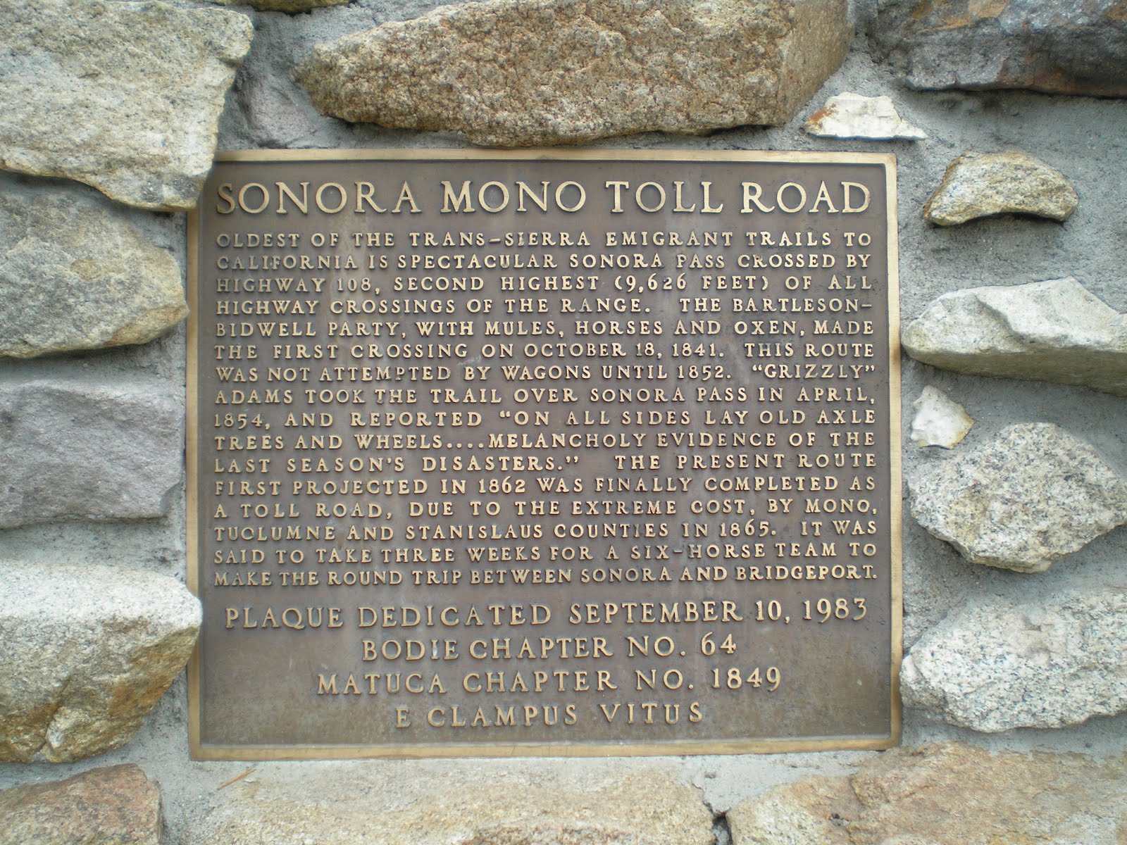
    Sonora Pass (9624') on CA108 is the pass I've used to cross the Sierra Nevada the most often. It's the second-highest trans-Sierra pass.


    My favorite pass is not on a California State Route but is on US Forest Service Road #22S05 near the southern end of the Sierra Nevada. On a clear day one can see Mt Whitney to the NNE from the Vista Area atop Sherman Pass (9200'). Hwr, while paved, the road is not accessible by vehicles towing moderate to large trailers such as 5th-Wheelers. And most Class A RVs will be unable to navigate the hairpin turns from Kernville to Sherman Pass. [SeeTRGLinks below.]


    Ebbetts Pass (8736')is not for the faint-of-heart since it has improved only slightly from when it was a trail for the Miwok and Washoe Indians. Oh, this 4th-highest (by my rankings) pass on CA4 is passable, but avoid it unless you are an experienced driver of mountain roads.


    Red Lake near Carson Pass (8574') is not too far from Lake Tahoe on CA88.


    A California State Historical Landmark on US50 for Echo Summit, near where the U.S. Track Team trained for the 1968 Olympics in Mexico City.


    Donner Pass, named after the ill-fated Donner Party of 1846-7, has a couple of different heights depending on which road you use, 7056' or 7240' (Euer Saddle). [See the link below to Wikipedia's list of California's Mountain Passes.]


    The lowest of the trans-Sierra passes: Beckwourth Pass (5221').


Links:
TRG Links:
Routes:
  • F 26 Aug Actual Route: DWL's - Aptos Lib - Marina W/M - Castroville - DWL's
  • Sa 27 Aug Actual Route: DWL's - Salvation Army - Goodwill - DWL's
  • ...
  • T 30 Aug Actual Route: DWL's - Aptos Lib - Los Banos - Watorford - Groveland R/S
  • W 31 Aug Actual Route: The Pines USFS CG - Crane Flat - Tioga Pass - Benton - Montgomery Ps - US95 R/A
  • Th 1 Sep Actual Route: US95 R/A - Tonapah,NV - RR Vy - Ely - Prospector Casino RV Pk
  • F 2 Sep Actual Route: Prospector RV Pk - Baker - Gt Basin NP - Delta,UT - Salina (Hollys Pantry)
  • Sa 3 Sep Actual Route: Hollys Pantry - Green River - Grand Jcn,CO, Lowe's - Rimrock Rd W/M
  • Su 4 Sep Actual Route: Rimrock Rd W/M - $ Tree - Lowe's - Rimrock Rd W/M
  • M 5 Sep Route: Rimrock Rd W/M - Lowe's - Rimrock Rd W/M
  • T 6 Sep Route: Rimrock Rd W/M - Sears - Rifle

Finding Campgrounds:

N.B. I receive nothing from Trailer Life, Woodalls, or FreeCampsites.net for including links to their free campground lookups.

Saturday, April 30, 2016

Bishop to the Clark Fork via Sonora Pass

Bishop to the Clark Fork via Sonora Pass Atherton, CA, Library
    All of these photos were taken on Friday 3 Jun 2016 during a drive north from Bishop, CA, along US395N to Sonora Junction and thence west along CA108 over Sonora Pass.
    This first photo was taken near the top of the climb from the Owens Valley to near Sherwin Summit. It's of the White Mountains to the east.

     With both the White Mtns and the Sierra Nevada reaching peaks above 14,000', and Bishop situated at 4,150', Genny Schumacher titled her book on the Owens Valley The Deepest Valley.


    A look at both Round Valley to the right and the Owens Valley extending south from the center of this photo not too far from Sherwin Summit.


    Though I'm not certain, I believe this photo was taken just north of Sherwin Summit before US395N reaches Crowley Lake.


    Excluding the ski areas near Lake Tahoe, Mammoth Mountain is the most popular ski area on the east side of the Sierra Nevada -- especially for those living in southern California.
    Mammoth Mountain is triangular-shaped when viewed from the south or north. Note the Minarets in the low spot along the Sierra Nevada crest (Minaret Summit) between Mammoth and the three sharp-pointed peaks to the north.


    Driving a bit north, here's a closer look at Mammoth Mountain and the Minarets.


    This shot as well as the next show the difference between the Minarets and most of the rest of the Sierra Nevada.


    Looking south along the northern edge of Mono Lake.


    Panning left...


    Panning again...


    Panning yet again...


    Zooming in...


    The muddy Walker River just east of the USMC Pickle Mdw Moutain Warfare Training Center.


    Looking upstream...


    Looking NE into Nevada one still sees snow on the higher peaks.


    Looking up Leavitt Creek, which is visible through the trees directly below the highest peak, and CA108 toward Sonora Pass, which is out of this photo to the right.


    Sonora Pass, second in height only to Tioga Pass of the trans-Sierra passes.


    Looking upstream from the bridge over the Clark Fork of the Stanislaus River.


    Last link below to Middle Fork of Stanislaus bridge, which is less than 100 yds from the Clark Fork bridge.


Links:
Routes:
    --
  • Su 14 Aug Actual Route: CA1N bd - East Cliff $ Tree - SV Lib - WHL's - CA1N bd
  • M 15 Aug Actual Route: CA1N bd - Lighthouse Pt - SV Lib - APC Propane - CA1N bd
  • T 16 Aug Actual Route: CA1N bd - Lighthouse Pt - Aptos P.O. - SV Lib - CA1N bd
  • W 17 Aug Actual Route: CA1N bd - Lighthouse Pt - Aptos P.O. - SV Lib - WHL's - CA1N bd
  • Th 18 Aug Actual Route: CA1N bd - Lighthouse Pt - Capitola VA Clinic - SV Lib - CA1N bd
  • F 19 Aug Actual Route: CA1N bd - Lighthouse Pt - SV Lib - SV $ Tree - CA1N bd
  • Sa 20 Aug Actual Route: CA1N bd - Lighthouse Pt - SV Lib - CA1N bd
  • Su 21 Aug Actual Route: CA1N bd - Lighthouse Pt - SV Lib - CA1N bd
  • M 22 Aug Actual Route: CA1N bd - Lighthouse Pt - Aptos Lib - CA1N bd
  • T 23 Aug Route: CA1N bd - Lighthouse Pt - SV Lib - S Tree - CA1N bd

Finding Campgrounds:

N.B. I receive nothing from Trailer Life, Woodalls, or FreeCampsites.net for including links to their free campground lookups.

Monday, August 13, 2012

Monitor Pass to Sonora Pass, CA

East of Long Barn, CA     Silver Creek, which CA4 follows on the east side of Ebbetts Pass. Looked in several holes, but couldn't spot fish of any size. However, once Silver Creek veers away from the highway, I suspect one can find more fish. It joins the East Fork of the Carson River, which joins other forks of the Carson in their journey to Lahontan Reservoir near Silver Springs, NV.


    The East Fork of the Carson downstream from its confluence with Wolf Creek.


    Since thunder-bumpers were in the forecast I stopped on the west side of Monitor Pass and took several photos.


    Panning left one can see that it's clear to the west and south.


    Note that there's virtually no snow left on the east side of the Sierra Nevada Mountain Range in the distance.


    Looking south the peaks seem to be getting higher, with elevations of 10-11,000 feet.


    Just over the top of Monitor Pass (elev: 8314') I took a photo of a couple of young "love-birds" with their camera and then took this shot looking south.


    Panning left one can barely see the top of the mountains just inside the Nevada border to the east because of the rain.


    Panning further left we see some green in the valley below as well as the aforementioned young couple taking photos of each other.


    Two miles east of the Marine Mountain Warfare Training Camp I parked at the same wide-out I used last fall after all of the USFS camps had closed for the season.     This is the West Walker River.


    The West Walker River a bit farther downstream. While I looked for rises several time, I never say any -- perhaps because I was simply too far away.


    While the White Mountains are farther south on the east side of the Owens Valley, the mountains in the distance, which are likely in Nevada, might also be called the White Mtns.


    From CA108 looking across Pickel Meadow toward what may be Matterhorn Peak on the crest of the Sierra Nevada.


    Zooming in, Sardine Falls is visible just above the trees. [Click one to enlarge; press ESC to return here.]


    At long last, a parking spot atop Sonora Pass (elev:9634')-- though I chose a spot a bit down the western side.


    [Click once to enlarge; press ESC to return here.] I see to have forgotten that the original Sonora Mono Toll Road when up the Clark Fork of the Stanislaus River.


    Enlarge to read another history of the Sonora Toll Road.


    I drove to the end of the Clark Fork [of the Stanislaus] Road to get a photo of the dominant monolith at Iceberg Meadows: the Iceberg. The photo thru the pines & cedars is about a quarter mile up the Disaster Creek Trail.


    At about the 3/8 mi point up the Disaster Crk Trail I got a somewhat better photo. However, hunger pains & weak leg muscles caused me to head back to my camper.


    While eating lunch I realized that there is a clear view of the Iceberg across the meadow. Here's a shot of the meadow, which is private property; you can see the base of the Berg just above the trees.


    The Iceberg.


    There was much fallen timber on the LDS Liahontan property next to the Arnot Creek Trailhead.


    Information on the Carson-Iceberg Wilderness in the headwaters of the Stanislaus and Mokulumne Rivers.
--


Links:

  • Links to follow shortly.

--

Th 16 Aug Actual Route: 1 mi E of N.F. Tuolumne Riv bd - Mi-Wuk Willage - Sonora - Mi-Wuk Village - 1 mi E of N.F. Tuolumne Riv bd

F 17 Aug Actual Route: 1 mi E of N.F. Tuolumne Riv bd - Mi-Wuk Willage - Sonora - Mi-Wuk Village - 1 mi E of N.F. Tuolumne Riv bd

Sa 18 Aug Actual Route: 1 mi E of N.F. Tuolumne Riv bd - Mi-Wuk Willage - Tuolumne - Sonora - Mi-Wuk Village - 1 mi E of N.F. Tuolumne Riv bd

Su 19 Aug Actual Route: 1 mi E of N.F. Tuolumne Riv bd - Mi-Wuk Willage - 1 mi E of N.F. Tuolumne Riv bd

M 20 Aug Route: 1 mi E of N.F. Tuolumne Riv bd - Mi-Wuk Willage - 1 mi E of N.F. Tuolumne Riv bd

--

Finding Campgrounds:

N.B. I receive nothing from Trailer Life, Woodalls, or FreeCampsites.net for including links to their free campground lookups.