East of Long Barn, CA
 Silver Creek, which CA4 follows on the east side of Ebbetts Pass. Looked in several holes, but couldn't spot fish of any size. However, once Silver Creek veers away from the highway, I suspect one can find more fish. It joins the East Fork of the Carson River, which joins other forks of the Carson in their journey to Lahontan Reservoir near Silver Springs, NV.

The East Fork of the Carson downstream from its confluence with Wolf Creek.

Since thunder-bumpers were in the forecast I stopped on the west side of Monitor Pass and took several photos.

Panning left one can see that it's clear to the west and south.

Note that there's virtually no snow left on the east side of the Sierra Nevada Mountain Range in the distance.

Looking south the peaks seem to be getting higher, with elevations of 10-11,000 feet.

Just over the top of Monitor Pass (elev: 8314') I took a photo of a couple of young "love-birds" with their camera and then took this shot looking south.

Panning left one can barely see the top of the mountains just inside the Nevada border to the east because of the rain.

Panning further left we see some green in the valley below as well as the aforementioned young couple taking photos of each other.

Two miles east of the Marine Mountain Warfare Training Camp I parked at the same wide-out I used last fall after all of the USFS camps had closed for the season.
This is the West Walker River.

The West Walker River a bit farther downstream. While I looked for rises several time, I never say any -- perhaps because I was simply too far away.

While the White Mountains are farther south on the east side of the Owens Valley, the mountains in the distance, which are likely in Nevada, might also be called the White Mtns.

From CA108 looking across Pickel Meadow toward what may be Matterhorn Peak on the crest of the Sierra Nevada.

Zooming in, Sardine Falls is visible just above the trees. [Click one to enlarge; press ESC to return here.]

At long last, a parking spot atop Sonora Pass (elev:9634')-- though I chose a spot a bit down the western side.

[Click once to enlarge; press ESC to return here.] I see to have forgotten that the original Sonora Mono Toll Road when up the Clark Fork of the Stanislaus River.
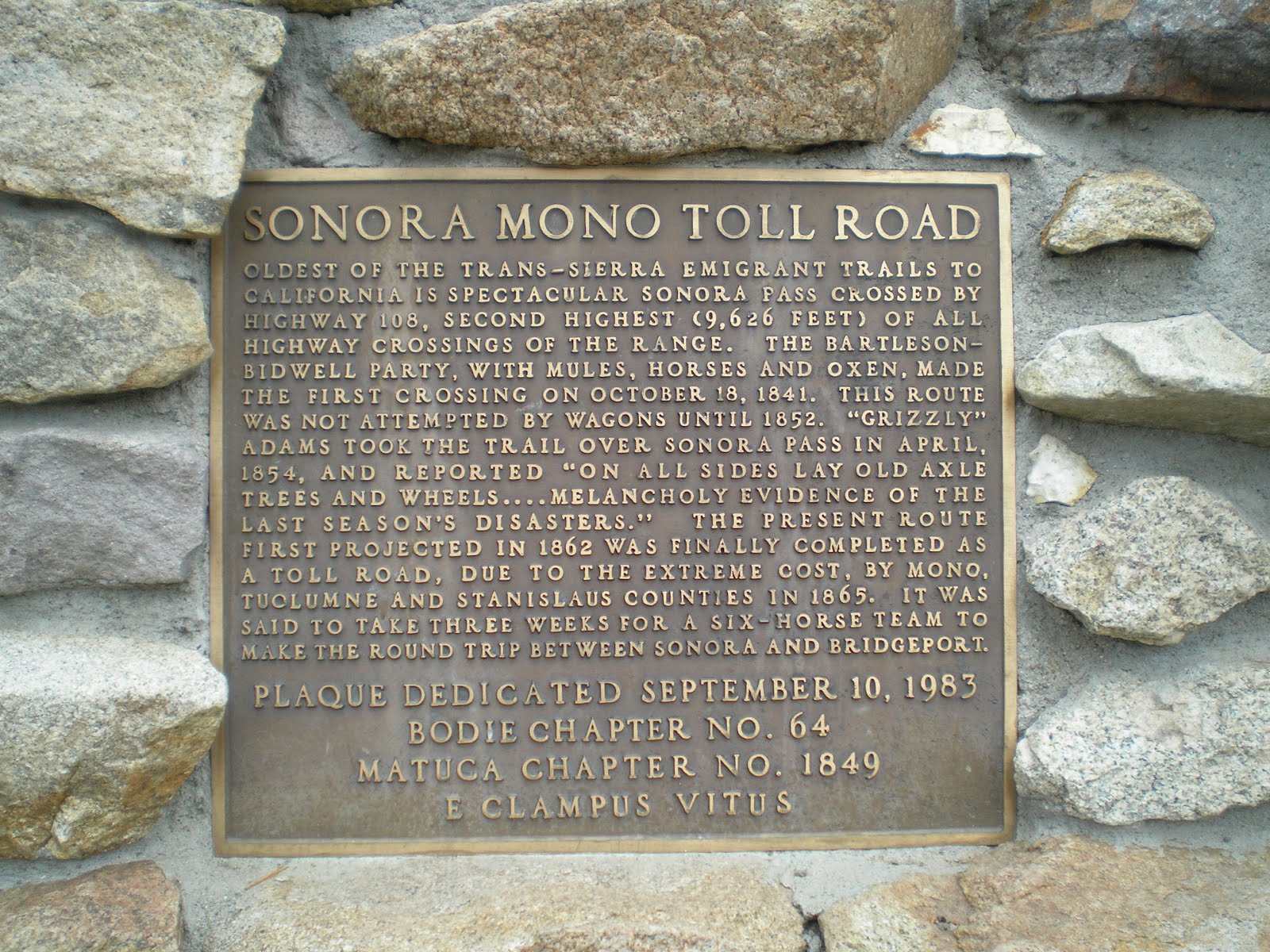
Enlarge to read another history of the Sonora Toll Road.

I drove to the end of the Clark Fork [of the Stanislaus] Road to get a photo of the dominant monolith at Iceberg Meadows: the Iceberg. The photo thru the pines & cedars is about a quarter mile up the Disaster Creek Trail.

At about the 3/8 mi point up the Disaster Crk Trail I got a somewhat better photo. However, hunger pains & weak leg muscles caused me to head back to my camper.

While eating lunch I realized that there is a clear view of the Iceberg across the meadow. Here's a shot of the meadow, which is private property; you can see the base of the Berg just above the trees.

The Iceberg.

There was much fallen timber on the LDS Liahontan property next to the Arnot Creek Trailhead.

Information on the Carson-Iceberg Wilderness in the headwaters of the Stanislaus and Mokulumne Rivers.
--
Links:
- Links to follow shortly.
--
Th 16 Aug Actual Route: 1 mi E of N.F. Tuolumne Riv bd - Mi-Wuk Willage - Sonora - Mi-Wuk Village - 1 mi E of N.F. Tuolumne Riv bd
F 17 Aug Actual Route: 1 mi E of N.F. Tuolumne Riv bd - Mi-Wuk Willage - Sonora - Mi-Wuk Village - 1 mi E of N.F. Tuolumne Riv bd
Sa 18 Aug Actual Route: 1 mi E of N.F. Tuolumne Riv bd - Mi-Wuk Willage - Tuolumne - Sonora - Mi-Wuk Village - 1 mi E of N.F. Tuolumne Riv bd
Su 19 Aug Actual Route: 1 mi E of N.F. Tuolumne Riv bd - Mi-Wuk Willage - 1 mi E of N.F. Tuolumne Riv bd
M 20 Aug Route: 1 mi E of N.F. Tuolumne Riv bd - Mi-Wuk Willage - 1 mi E of N.F. Tuolumne Riv bd
Finding Campgrounds:
- RV Campgrounds from TrailerLifeDirectory.com
- Family Camping Directories from Woodalls.com
- Free campsites website
- Info on finding BLM Campgrounds
No comments:
Post a Comment