Orland, CA

Lake Britton, which lies just upstream from Burney Falls. [I did see one rise on this Saturday 10 October morning when the wind died down.]

Looking generally NE up Lake Britton from the USFS Dusty Campground, which, while created by PG&E is managed by the USFS; it was closed for the season, but the access gate was not only not locked but likely had not been locked for several years.

A view down the lake toward a RR bridge which is no long in use.

A "veiled" glimpse of Burney Falls through the trees.

[Click 1 or 2 times to enlarge] An explanation of what might be called a microclimate.

A closer look at Burney Falls, which is named after a drifter named Samuel Burney from South Carolina. He was unfortunately in the wrong place at the wrong time. That is, while caring for property owned by Thomas Preadmore, who apparently had mistreated several Indian women, a group of them came looking for revenge. Burney paid the ultimate price -- and, thereafter, many local features were named after him.

At the bottom of the trail, a clear view of the falls. But, in case you're wondering why the park is named McArthur-Burney Falls Memorial State Park, here's the explanation from the park's brochure. "John and Catherine McArthur arrived in the 1860s, purchased thousands of acres, and opened a mercantile store in the area. In 1917 the newly formed Pacific Gas & Electric Company began buying up land and water rights in the area. [Continued below.]

A rather large winged insect which was trying to escape my camera's closeup. [More on the McArthurs: "Alarmed residents became concerned that PG&E, in the interests of providing more hydroelectric power, might dam the Pit River and destroy Burney Falls. Frank and Scott McArthur, sons of John and Catherine, purchased 160 acres surrounding the falls, and in 1920 they deeded the property to the State Board of Forestry, requesting only that it be named for their parents."]

Click once or twice to read the explanation of the porous volcanic rock and Burney Falls.

When Theodore Roosevelt saw the falls he said it was one of the wonders of the world; see Wikipedia link below. [It's unknown if he used the same expression he used one morning on a camping trip in Yosemite with John Muir and they woke up with snow on their blankets: Bully!]

"Year round about 100 million gallons a day of clear, cold water flow over the ancient, craggy rock face of the falls."

A slightly different view of the falls with more sunlight.

DFG fishing restrictions for Burney Creek from the base of the falls to Lake Britton.

Rainbow Bridge, roughly 200 yards below the falls.
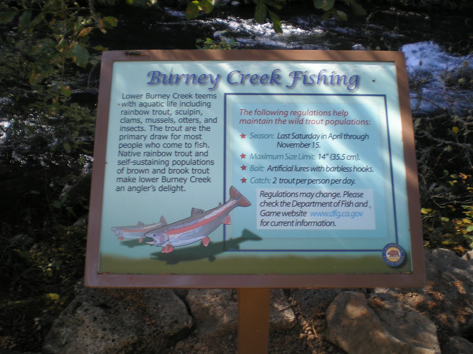
A repeat of the fishing restrictions on Burney Creek from the falls to Lake Britton. However, there is additional information: 1)the stream contains brook and brown trout in addition to native rainbows; and 2)a web address for DFG restrictions, etc.
--
Links:
- McArthur-Burney Memorial State Park website; it is California's 2d oldest park
- Wikipedia article on McArthur-Burney Falls
- Brief RoadTripAmerica piece on Burney Falls
Sa 8 Oct Actual Route: Lake Britton - Burney Falls - Burney - Lassen NP - Gurnsey Crk CG
Su 9 Oct Actual Route: Gurnsey Crk - Chester - Butte Mdws CG
M 10 Oct Actual Route: Butte Mdws CG - Forest Ranch - Chico - Orland Old Orchard RV Park
T 11 Oct Actual Route: Orland - Willows - Glenn - Oroville
W 12 Oct Route: Oroville
--
Finding Campgrounds:
- RV Campgrounds from TrailerLifeDirectory.com
- Family Camping Directories from Woodalls.com
Can anyone tell me who Lake Britton was named for.
ReplyDeleteSteve,
DeleteSince there was an ancestral lake named Lake Britton caused by a lava flow, it's unlikely some PG&E employee named the lake.
--
Bob L Jr
RoadGen
Thank you. I would like to look into the ancient lake for historical reasons, such as when it was formed and when it disappeared. Thanks again sir.
ReplyDeleteSteve,
ReplyDeleteNeglected to include the following link.
....
http://www.geocaching.com/geocache/GC1X4EQ_ancestral-lake-britton-diatomite-deposits
....
Hope this helps.
--
Bob L Jr
RoadGen