Shingletown, CA
As some of you know I've been chomping at the bit to visit Lassen National Park for the first time. It finally opened 2 days after I left my sister's place in Shingletown and eventually traveled north to Oregon on CA97.
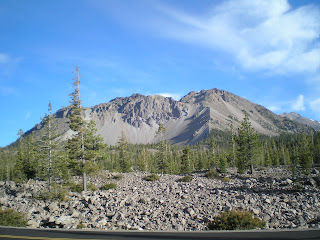
The photo to the right is from the Southwest Entrance road branching north from CA36 and is of Mt Conard (elev: 8240').
At the left, the top of Lassen Peak (10457'); in the middleground, a craggy mountain called Diamond Peak (7968'); and to the right of the large red fir loaded with cones in the middle of the photo: Bumpass Mtn (8753'). [Incidentally, Bumpass is the name of a former USPS employee -- not what happens when you fall on your posterior!] The yellow-whitish area, caused by sulfate crystals, is still an area of geothermal activity.
[Click 1 or 2 times to zoom in.] A view back down toward the Kohm Yah-mah-nee Visitor Center through the trees just above the bridge railing below the Sulfur Works.
Mount Diller (9087') in front with Pilot Pinnacle (8886') behind it as seen from the first large hairpin turn up the road from the Sulphur Works.
Another view of Mt Diller and Pilot Pinnacle from further up the road.
A closer shot of Diamond Peak as I look for a place to stop for lunch.
A clear view of Lassen Peak as well as a parking place where I ate lunch.
[Click 1 or 2 times to enlarge.] What does the top of Diamond Peak look like to you? A crown where the left side had fallen? A turtle on its back kicking its feet and complaining, "I fell over backwards and can't get up"?
Yet another view of Mt Diller and Pilot Pinnacle.
Lassen Pk as seen from the Bumpass Parking Lot.
Lake Helen as seen from near the highest point on the road through Lassen NP.
A plaque on the downhill side of high point (8512') in the road, which was built in 1925 and maintained and improved by the Civilian Conservation Corps from 1933 to 1940.
At first glance the lake in the distance might be Juniper Lake, the biggest lake in the park. However, it's too large and almost certainly is Lake Almanor.
Panning to the left slightly there appears to be another lake in the distance; believe that's the eastern (Big Springs) portion of Lake Almanor.
I took this shot of the top of Lassen Peak and because there appeared to be a small white structure near the top; however, I should have zoomed in bit before shooting this since I can't make out anything on the top.
The top of Lassen Peak as seen across Kings Creek's Upper Meadow.
Summit Lake from a campground closed for the season. (Since there was a controlled burn [management burn in USPS-speak] nearby, the closure was warranted.)
Hot Rock. No, a thief didn't ditch this "hot rock" as a posse closed in on him; rather, a May 19, 1915 eruption propelled it to the spot where B.F. Loomis took this photo.
Crescent Crater (8645'), where the "blowout area" is reminiscent of another more recent blowout of another mountain in the Cascade Range: Mount St Hellens in Washington.
Manzanita Lake, which at one time contained large brown trout -- and, despite the efforts of nimrods, may still harbor a few.
The larger northeastern portion of Manzanita Lake. Incidentally, fishing at Manzanita is now catch and release only. Artificial lures with a single barbless hook and no power bait. Manzanita Creek above the lake is closed to fishing.
--
Links:
- Nearly a verbatim transcription of the park brochure
- Wikipedia article on Lassen Natl Park with ourstanding photos
- Wikipedia article on Burney, CA
Su 2 Oct Actual Route: Lake Almanor - Lassen NP - Shingletown
M 3 Oct Actual Route: Shingletown
T 4 Oct Actual Route: Shingletown
W 5 Oct Actual Route: Shingletown
Th 6 Oct Actual Route: Shingletown - Anderson - Sacto River RV Park
F 7 Oct Actual Route: Sacto River RV Park - Redding - Burney - Lake Britton
Sa 8 Oct Actual Route: Lake Britton - Burney Falls - Burney - Lassen NP - Gurnsey Crk CG
Su 9 Oct Actual Route: Gurnsey Crk - Chester - Butte Mdws CG
M 10 Oct Atual Route: Butte Mdws CG - Forest Ranch - Chico - Orland Old Orchard RV Park
--
Finding Campgrounds:
- RV Campgrounds from TrailerLifeDirectory.com
- Family Camping Directories from Woodalls.com


No comments:
Post a Comment