Massacre Rocks State Park, Idaho
An Idaho State Historical Marker (or billboard) at a Rest Area just east of Massacre Rocks State Park. [Incidentally, only 8 or 9 travelers were killed by the Shoshoni; a promoter in the 1920s decided to hype the event by calling it a massacre.]
[Click once to see an enlarged, more-readable photo.]
Looking back up the road from near Register Rock to Massacre Rocks SP one can see large 3-bladed wind turbines similar to those on Altamont Pass between Fremont in the Bay Area and Tracy in the Central Valley.
Panning left one can see the placid Snake River -- though I did hear some radio forecast of possible flooding as warmer weather melts some of the snow.
Panning furter left you can see a large island; sometimes those using the Oregon Trail attempted to cross the Snake at flat spots where there were multiple islands.
Another look down the broad Snake River.
The grove of trees on the left side of the road are where Register Rock was deposited during the Bonneville Flood. Those using the Oregon trail often scratched or chiseled their names in the rock. [Since there was a $5 parking fee, I turned around & headed back up the hill from which I took many of these photos before eating lunch. See links below.]
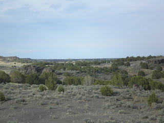
Note two signs of the Bonneville Flood approximately 14,500 years ago: 1)Large boulders on the flat below as well as 2)a gap in the table mountain along the Snake River's northern edge.
A view up the Snake River Valley toward American Falls, where some of the taller building or grain elevators are visible from c10 miles downstream.
A closer look at the Big Sagebrush on this side of I-86 with large wind turbines among the Utah junipers on the other side.
While Idaho seems to have plenty of water, here's evidence that there are pockets of dryness amongst the greenery: a young [probably 2-3 years old] prickly-pear cactus trying to gain a foothold.
--
Links:
- Idaho State Park web pages on Massacre Rock State Park
- Wikipedia article on the Bonneville Flood
- Wikipedia article on Burley, Idaho
Sa 28 Apr Actual Route: Willow Bay RV Park - American Falls Lib - Massacre Rocks State Park
Su 29 Apr Actual Route: Massacre Rocks State Park - Burley - Oakley City RV Park
M 30 Apr Actual Route: Oakley City RV Park - City of Rocks National Reserve - Almo - Elba - Malta - Declo - Burley bd
T 1 May Actual Route: Burley bd - Burley Lib - Kimberley - Twin Falls - Perrine Memorial Bridge - Twin Falls Walmart
W 2 May Actual Route: Twin Falls Walmart - Twin Falls Lib - Shoshone Falls - Buhl - Miracle Hot Springs RV Park
Th 3 May Route: Miracle Hot Springs RV Park - Hagerman - Bliss - Gooding
Finding Campgrounds:
- RV Campgrounds from TrailerLifeDirectory.com
- Family Camping Directories from Woodalls.com
- Free campsites website
- Info on finding BLM Campgrounds


No comments:
Post a Comment