Sunday, April 28, 2013

Santa Cruz Mission de la Canada, New Mexico

Santa Cruz Mission de la Canada, New Mexico

Spanish Peaks Library, Walsenburg, CO

    As a Californian when I hear the phrase "Spanish Missions" I think of the twenty-one missions primarily created by Father Junipero Serra from San Diego to Sonoma. And the El Camino Real links many of them, especially on the San Francisco Peninsula.
    My hometown is Santa Cruz, CA, which has a mission that was dedicated in 1797 and, after several floods along the San Lorenzo River, moved to a hill just above the flood plain. Imagine my surprise when I drove to Santa Cruz, New Mexico and discovered another Santa Cruz Mission on another El Camino Real.


     [Click once to enlarge; press ESC to return here.]


    I believe somewhere I saw that the Santa Cruz Mission on the north side of the Santa Cruz River was constructed in 1733.


    From under the front arch, the front door and the churches two bell towers.


    A view from in front of the step to the front door of the church to the arch and the large, white cross in the plaza.


    A shrine to the Virgin Mary and, perhaps, one of the bells from the two bell towers of the church.


    Another look at the rather ornate door to the Santa Cruz Mission and the stained-glass window above.


    One last look at Santa Cruz Mission de la Canada from the adjacent cemetery.


Links: Return to Top of Page

Th 2 May Actual Route: La Junta Walmart - La Junta Lib - La Junta Walmart

F 3 May Actual Route: La Junta W/M - La Junta Lib - Old Bent's Fort - Rocky Pt - Fowler - Pueblo W/M

Sa 4 May Actual Route: Pueblo W/M - Lamb Br Lib - Pueblo W/M

Su 5 May Actual Route: Pueblo W/M - Pueblo Main Lib - Pueblo W/M

M 6 May Actual Route: Pueblo W/M - Lamb Br Lib - Walsenburg Lib - US160W bd

T 7 May Actual Route: US160W bd - Walsenburg Lib - LaVeta Lib - Fort Garland bd

W 8 May Actual Route: Fort Garland bd - Fort Garland/Blanca Lib - Great Sand Dunes NP - Pinyon Flats CG

Th 9 May Actual Route: Great Sand Dunes NP Pinyon Flats CG - Ft Garland/Blanca Lib - Ft Garland P.O. - Alamosa Lib - Alamosa W/M

F 10 May Route: Alamosa W/M - Alamosa Lib - Alamosa W/M


Finding Campgrounds:

N.B. I receive nothing from Trailer Life, Woodalls, or FreeCampsites.net for including links to their free campground lookups.

Thursday, April 25, 2013

Carlsbad Caverns National Park, New Mexico

Carlsbad Caverns National Park, New Mexico

Lamb Branch Library, Pueblo, CO


    Since I'm a skinflint, I opted to take a 1.5-hour, 1-mile self-guided tour of part of "The Big Room." The people you see in the center of the photo are those near where the two elevators deposit one after a quick descent.


     Stalagtites and stalactites galore! As we learned in school the former grew from the ground up whereas the latter developed from the ceiling downward.


    The park service has distributed lights throughout the Caverns in order either to to highlight a limestone formation or to backlight it.


    Plenty of light in this shot even though parts of the formations are black.


    Sometimes the formations from the ceiling are called draperies; if they're long and thin, they're called "Soda Straws."


    No bats here; they're in another part of the cave near its natural entrance.


    One of the more spectacular groups of limestone formations. Believe the stalagmite on the right is called the "Giant Dome" and the two formations on the left are called "Twin Domes."


    Though these small formations look like ice crystals, they're not; believe the temperature in the caverns remains at a fairly constant 56 degrees throughout the year. [Think they're called "popcorn." Not so; Popcorn hangs from "Soda Straws."]


    What looks like snow is really limestone -- a "Flowstone."


    If you have an imagination, these two formations look like a grandfather talking with his grandson.


Links: Return to Top of Page

Sa 27 Apr Actual Route: Cimarron bd - Cimarron - Raton Lib - Capulin - NM325 bd

Su 28 Apr Route: Capulin NM325 bd - Capulin Volcano Natl Monument - Clayton - Clayton Lake SP

M 29 Apr Actual Route: Clayton Lake SP - Kenton, OK - NM706 bd

T 30 Apr Actual Route: NM706 bd - Clayton Lib - Capulin Volcano NM - Folsom - Branson, CO - Trinidad Walmart

W 1 May Actual Route: Trinidad W/M - Thatcher - La Junta Lib - La Junta Walmart

Th 2 May Actual Route: La Junta Walmart - La Junta Lib - La Junta Walmart

F 3 May Actual Route: La Junta W/M - La Junta Lib - Old Bent's Fort - Rocky Pt - Fowler - Pueblo W/M

Sa 4 May Actual Route: Pueblo W/M - Lamb Br Lib - Pueblo W/M

Su 5 May Actual Route: Pueblo W/M - Pueblo Main Lib - Pueblo W/M

M 6 May Route: Pueblo W/M - Lamb Br Lib - Walsenburg Lib


Finding Campgrounds:

N.B. I receive nothing from Trailer Life, Woodalls, or FreeCampsites.net for including links to their free campground lookups.

Sunday, April 21, 2013

Santa Fe, New Mexico

Santa Fe, New Mexico

Raton Public Library, New Mexico


    Because the traffic was thick around the State Capitol building in Santa Fe, in part due to road construction, I opted to find a quiet place to eat lunch -- and chose the Santa Fe National Cemetery.
    While eating I decided to photograph two headstones, most of which are for WWII vets; This first one is for a Sgt First Class who served both in WWII and Korea: Harold Wesley Webb, whose life may have been shortened to 48 years by his military service. [See Links below.]


     The second headstone is for Robert Munro Sr, a Spanish American War Vet.


    Amongst the State Capitol buildings I found a Memorial to the men of the 200th Coast Artillery; it was made while they were stationed at Ft Bliss, TX in 1941 before being deployed to the Philippines to defend the Battan Peninsula; some died during the infamous Battan Death March during WWII. As noted in the plaque, this entire monument was moved from Ft. Bliss, TX, to Santa Fe, NM, to serve as a memorial for the men of the 200th Coast Artillery.


    A statue of a Civilian Conservation Corps worker.


    The statue above was designed by by Sergey Kazaryan and the men to CCC Chapter 129, Mid-Michigan. Cast by the Fine Arts Centre, Michigan.


    Made one more pass through the area abound the State Capitol and took this photo while waiting to make a right turn during rush hour with continuing road construction. Not sure if this is San Miguel Catholic Church, which is in the area; however, there are several Catholic Churches in the area.


Links: Return to Top of Page

Th 25 Apr Actual Route: Espanola Walmart - Velarde - Taos Library - Taos Walmart

F 26 Apr Actual Route: Taos Walmart - Taos Library - Eagle Nest - near Cimarron bd

Sa 27 Apr Actual Route: Cimarron bd - Cimarron - Raton Lib - Capulin - NM325 bd

Su 28 Apr Route: Capulin NM325 bd - Capulin Volcano Natl Monument - Clayton - Clayton Lake SP

M 29 Apr Actual Route: Clayton Lake SP - Kenton, OK - NM706 bd

T 30 Apr Actual Route: NM706 bd - Clayton Lib - Capulin Volcano NM - Folsom - Branson, CO - Trinidad Walmart

W 1 May Actual Route: Trinidad W/M - Thatcher - La Junta Lib - La Junta Walmart

Th 2 May Actual Route: La Junta Walmart - La Junta Lib - La Junta Walmart

F 3 May Actual Route: La Junta W/M - La Junta Lib - Old Bent's Fort - Rocky Pt - Fowler - Pueblo W/M


Finding Campgrounds:

N.B. I receive nothing from Trailer Life, Woodalls, or FreeCampsites.net for including links to their free campground lookups.

Thursday, April 18, 2013

Guadalupe Mountains National Park, Texas

Guadalupe Mountains National Park, Texas

Taos Public Library, New Mexico


    Heading north on TX54 from Van Horn, here's a first view of the Guadalupe Mountains to the left of center. (It's a 74-mile drive from Van Horn to the Pine Springs Visitor Center.)


    A large ranch gate to the left had this Texas Historical Marker near it about the Figure 2 Ranch and its founder, James M. Daugherty. [Click once to enlarge; press ESC to return here.]


    The Guadalupe Mtns with Guadalupe Peak in in the center. Right? Only half-right, for the peak in the center is El Capitan.


    A view of El Capitan (elev: 8085') from US Highways 62 & 180 as they curve around the Guadalupes before heading north toward Carlsbad Caverns.


    The real Guadalupe Peak finally stands out below an interesting cloud formation; at 8749 ft. it's the highest point in Texas.


    Panning to the left from the Pine Springs Visitor Center, the trail to the top starts at the campground about 3/8s of a mile above up the road, and heads for the gap you see; my guess is that it follows the ridge to the top.


    Zooming in on both Guadalupe Peak and the cloud formation.


    Driving US62/180 toward McKittrick Canyon I stopped and took a photo of the Capitan [fossil] Reef -- with El Capitan prominent on the left.


    Since the round-trip walk up McKittrick Canyon to the [Wallace] Pratt Cabin is 4.8 miles, I made due with this photo from the McKittrick Canyon Visitor Center. Some of the trees listed in the canyon are maple, walnut, ash, oak, and chokeberry trees.


    The rugged northern edge of McKittrick Canyon from the parking lot.


    A first look at the Frijole Ranch, which was, for most of it history, known as the Smith Ranch.


    The the ranch was founded by the Rader Brothers, but the Smith family moved here in 1906. During the 34 years they lived here, they made weekly wagon trips to Van Horn to sell their produce. Apparently the road was shorter then, but, nonetheless, it took them all night to get there with their fruit and vegetables covered with wet papers and rags. [Click once to enlarge; press ESC to return here.]


    The key to the ranch's success: the spring, which is routed in several different directions from the corner of the spring-house.


    The ranch's equivalent of a fridge: a stone building with water from the spring routed through it.


    The back of the ranchhouse; note the small channel for the spring's water to run toward the garden and orchard.


    Since I wanted to take photos of some cacti as well as a nearby cinder cone, I almost left without checking out the orchard. This tree is a winesap apple.


    One of the many other fruit trees, which included apples, cherries, pears, persimmons, apricots, and even a crabapple.


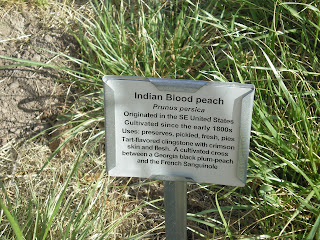
    Memories of Home. My late father planted an Indian blood peach in our yard in Santa Cruz, CA. And, as one of the links below indicates, Thomas Jefferson had a considerable number planted on his estate in Monticello, VA. [Click once to enlarge; press ESC to return here.]


    Two type of cacti, cholla & prickly-pear in front of a (Utah?) juniper.


    A cinder-cone near the Frijole/Smith Ranch.


Links: Return to Top of Page

T 23 Apr Actual Route: Santa Fe W/M - Southside Br Lib - Santa Fe Walmart

W 24 Apr Actual Route: Santa Fe W/M - Southside Br Lib - Santa Cruz - Espanola Walmart

Th 25 Apr Actual Route: Espanola Walmart - Velarde - Taos Library - Taos Walmart

F 26 Apr Actual Route: Taos Walmart - Taos Library - Eagle Nest - near Cimarron bd

Sa 27 Apr Actual Route: Cimarron bd - Cimarron - Raton Lib - Capulin - NM325 bd

Su 28 Apr Route: Capulin NM325 bd - Capulin Volcano Natl Monument - Clayton - Clayton Lake SP

M 29 Apr Actual Route: Clayton Lake SP - Kenton, OK - NM706 bd

T 30 Apr Actual Route: NM706 bd - Clayton Lib - Capulin Volcano NM - Folsom - Branson, CO - Trinidad Walmart

W 1 May Actual Route: Trinidad W/M - Thatcher - La Junta Lib - La Junta Walmart

Th 2 May Route: La Junta Walmart - La Junta Lib - La Junta Walmart


Finding Campgrounds:

N.B. I receive nothing from Trailer Life, Woodalls, or FreeCampsites.net for including links to their free campground lookups.

Sunday, April 14, 2013

Balmorhea State Park, Texas

Balmorhea State Park, Texas

Southside Branch Library, Santa Fe, New Mexico


    As I told my ex-fishing buddy in California, the area around Balmorhea State Park is one of the first I've seen in Texas where I'd consider living. The reason? Water.


    The source of the water in the Balmorhea area is the San Solomon Marsh/Spring, as explained in this plaque -- most of which is visible despite the reflection of a late afternoon sun.


    One of the many canals within the park. And outside of the park there are aqueducts flowing alongside the roads.


    As someone who fished in California from 1947 to 2008 (with the exception of 1962 when I was in Korea on R&R courtesy of the U.S. Army), I was interested in seeing if there were any fish in the canals.


    There are many fish in the canals, but I didn't see anything longer than four inches. And they're clearly not trout. In fact, given the temperature of the water (c75 degrees F.) in the Balmorhea swimming pool, built in 1935, they are some type of warm-water fish.


    There are likely more than one type of fish in the canals of Balmorhea SP.


    Rather than return to I-10, I drove Farm Road 3078 to the west so that I could get a photograph of the Texas State Flower: the Bluebonnet.


    Another shot of Bluebonnet wildflowers along with a white flower I first saw in the middle of Nevada; while it reminds me of a Mariposa Lily, which is widespread in the Sierra Nevada in California, this plant is characteristic of the SW; ie., it has numerous sharp spines.


http://www.blogger.com/blogger.g?blogID=6788340452357885309#editor/target=post;postID=3403226264408350603;onPublishedMenu=allposts;onClosedMenu=allposts;postNum=0;src=link


Links: Return to Top of Page

T 16 Apr Actual Route: Roswell Walmart - Roswell Lib - Hondo - Ft Stanton BLM bd

W 17 Apr Actual Route: Ft Stanton BLM bd - Capitan Lib - Carrizoso - Vaughn

Th 18 Apr Actual Route: Vaughn Truck Stop - Santa Rosa McDs - Santa Rosa Lib - Santa Rosa Lake SP

F 19 Apr Actual Route: Santa Rosa Lake SP - Santa Rosa McDs - Santa Rosa Lib - Las Vegas McDs - Las Vegas Walmart

Sa 20 Apr Actual Route: Las Vegas W/M - Ilfeld - Santa Fe Walmart

Su 21 Apr Actual Route: Santa Fe W/M - Santa Fe Natl Cem - State Capitol - Dollar Tree - Big Lots - Santa Fe W/M

M 22 Apr Actual Route: Santa Fe W/M - Southside Br Lib - State Capitol - Santa Fe Walmart

T 23 Apr Actual Route: Santa Fe W/M - Southside Br Lib - Santa Fe Walmart

W 24 Apr Actual Route: Santa Fe W/M - Southside Br Lib - Santa Cruz - Espanola Walmart

Th 25 Apr Route: Espanola Walmart - Velarde - Taos Library - Taso Walmart


Finding Campgrounds:

N.B. I receive nothing from Trailer Life, Woodalls, or FreeCampsites.net for including links to their free campground lookups.