Even though I finished my drive throught Death Valley Natl Park on 10 Feb I've decided to make this the most recent post; in 7-10 days I'll move it back to 11 Feb.
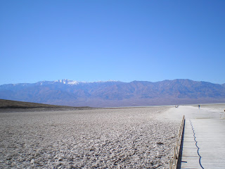
If there's one spot in Death Valley which is considered "must-see," it's Badwater at 282 ft below sea level. The first photo looks to the north up Death Valley; note that there is some water of the edge of the salt flat.
Click once or twice to zoom in.
Snow-capped Telescope Peak, the higest point in both the Panamint Range and Death Valley NP looms over the path out to presumably the lowest point at Badwater.
Click 1 or 2 times to enlarge.
The peak on the left is Telescope Pk, 11,049 ft.
Stopped past Jubilee Pass and just short of Salsberry Pass for a late lunch. Only saw a vehicle roughly every 20 minutes; my guess is that the route from Shoshone over Salsberry Pass is the least-traveled route to/from Death Valley.
Desert Holly--in bloom. Here's what the DV brochure had to say about this plant: "Death Valley's low moisture, intense sunlight, drying wind, and salt from nearby salt flats limit plant growth. Desert holly typifies plants adapting to deserts. Its silver-colored leaves reflect sunlight and turn on edge to reduce exposure. Dormant in summer, it grows and flowers in winter, pollinated not by insects but by wind. Insects appear when rare rains make spring wildflowers sprout and bloom.
--
Finally, looking into Nevada from the east side of Salsberry Pass.
Links:
- National Park Service web pages on Death Valley
- Brief history of Shoshone plus a passel of links


No comments:
Post a Comment