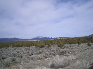
The drive today from Ely, NV, to Tonapah and then Goldfield was a traverse of several basins separated from each other by ranges of mountains. And that's why the interior of the state of Nevada is considered a prime example of the Basin & Range geography of the western United States.
After crossing Murray Summit, c6720', just west of Ely I pulled over to the left shoulder & took the photo to the right. While there is still some snow on the hill to the left as well as the mountain range in the distance, more is expected later this week. In fact, each night as I climbed into the cab-over and my sleeping bag, I listened to an AM station [530KHz?] which gave road conditions and overnight weather forecasts for the 3 US Highways which part ways at Ely: US6, US 50, & US93, (Just a reminder, even-numbered US & Interstate Highways run east-west while odd-numbered routes run north-south.)
As I descended into the next valley or basin I pulled over to take some photos and noticed what appeared to be a dam, which is visible above the healthy stand of junipers at the right center of the snapshot. Don't have I-net access right now, but will look up the name of the dam as well as the creek which damed to form which lake or reservoir.
This next shot is of the mountain range to the SW of the dam in the previous photo.
And this photo was taken to the left of the one above. Note that the junipers have thinned a bit in spots allow the sage-brush to spread.
Note the flat up ahead from this snap taken in the drainage which descends into the Railroad Valley at Currant. [Click 1 or 2 times to zoom in.]
Currant was essentially a ghost -- though the restaurant appears to have closed only 2 or 3 years ago. The primary biz in the RR Valley is not cattle ranching but rather oil drilling and refining.
There is also some mining underway in the RR Vy as is evident from the large white piles roughly due north of where I stopped.
And this is a view of the mountain range to the east of the RR Vy.
A look back at the Railroad Valley where a hardy few are scratching out a living raising cattle, mining, or drilling and refining oil.
The broad pass from the RR Valley to the next basin; like Blackrock Summit all of the passes were above 6000'.
I ask you, where can you stand in the middle of a US Highway and take a photo up or down the middle of the road without risking become road-kill? [Yes, US50 from Ely to Austin is called the loneliest highway in the U.S., but I only saw 7 vehicles headed east until I got to within 30 miles of Tonopah.
The climb to Warm Springs Summit, the 2d to last basin before one reaches Tonopah.
I stopped for lunch about 28 miles east of Tonopah at a Rest Stop; there were signs warning truckers not to enter the portion of the rest area set aside for cars or pickups. But since there were no signs prohibiting overnight parking, the Rest Area might do in a pinch for RVers caught late at night headed east on US6. RVers with large vehicles could park in the area set aside for semis. The pit toilet did not have any odor until one entered the concrete building -- though that might change during hotter weather.
Links:
T 15 Mar Actual Route: Ely - Currant - Warm Springs - Tonopah - Goldfield


You seem to have the same problem I do. :)
ReplyDeleteMany of your pictures are tilted upward on the right. I've corrected so many scans of my old slides I can't keep count.
Lately I've been enabling the grid in my digital camera so I can make the horizon parallel to it.